Every year brings new fascinating and wild weather events. 2014 was no different. As the year comes to a close, it’s worth looking back on all that happened.
January
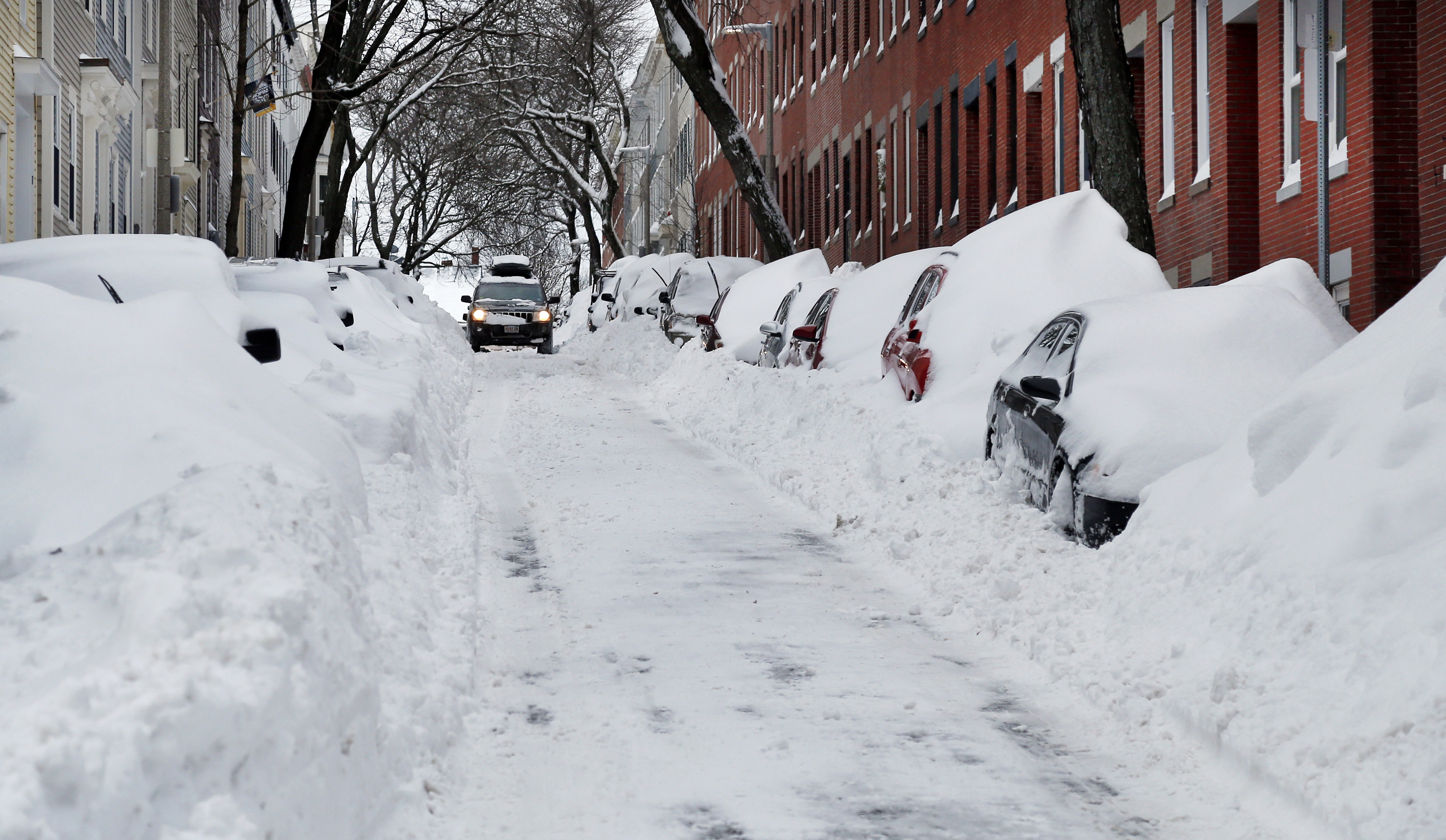
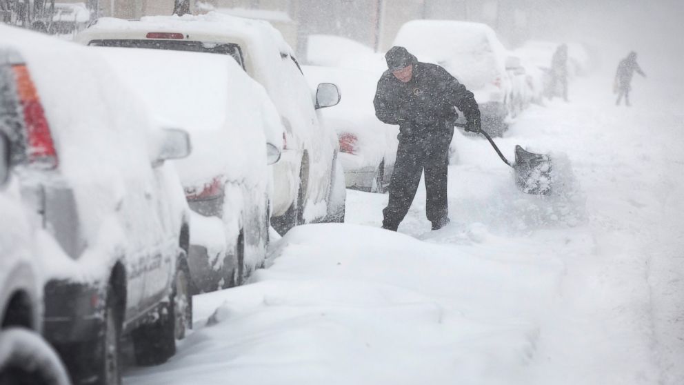
January was marked by frigid temperatures east of the Rockies. The Northeast and Great Lakes were hammered by snow. Seven inches fell on Boston on January 3 and the temperature dipped to 2F, with a wind chill of -20F. Portions of Massachusetts got nearly two feet of snow. Nearly a foot of snow fell on Detroit as temperatures fell to near 0F. On January 7th, New York City dropped to 4F, breaking a record that had stood for 116 years. That same day, Chicago dipped to -12F, part of four straight days of sub-zero temperatures that included -16F on January 6. Both readings were daily records. Philadelphia also dropped to 4F on January 7th, breaking a 26 year old record. The Schuylkill River, while not frozen over, was thick with ice. Lighter snow fell in central Tennessee as temperatures dipped to 9F on January 6 and 2F the following night. Midtown Atlanta dropped to 5F on January 7.

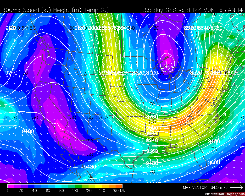
An upper air chart showing what ended up being the dominant pattern of the winter of 2013-2014, with a high pressure over the Rockies and an Arctic low over the Great Lakes, plunging the jetstream deep into the eastern US. Source: University of Wisconsin – Madison
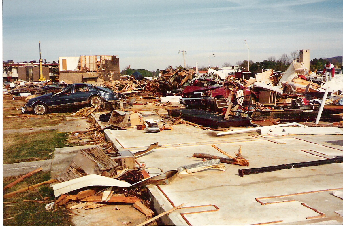
Beginning January 28, a major winter storm struck the southeast. Heavy sleet and ice accumulations occurred in Louisiana, central and southern Alabama, and central Georgia. Bridges across the Gulf Coast region were closed due to icing and sleet accumulations were observed all the way to the shoreline. Ice accumulations were as high as 0.5 inches in those regions. Overshadowing the ice event to the south, however, was the significant snow event that struck north-central Alabama and Georgia, including the metro areas of Atlanta and Birmingham. Initially, the storm was expected to remain to the south of those cities, with only light accumulations expected. As such, resources were shifted to the south as regions that were expected to be the hardest hit had very little snow and ice removal equipment. However, the storm made a late shift to the north. During the overnight hours on January 27-28, predictions went from around one inch to around three inches and winter storm warnings were expanded to include the entire Atlanta metro area at 3:38 am. Warnings were not issued in Birmingham until almost the start of morning rush hour.

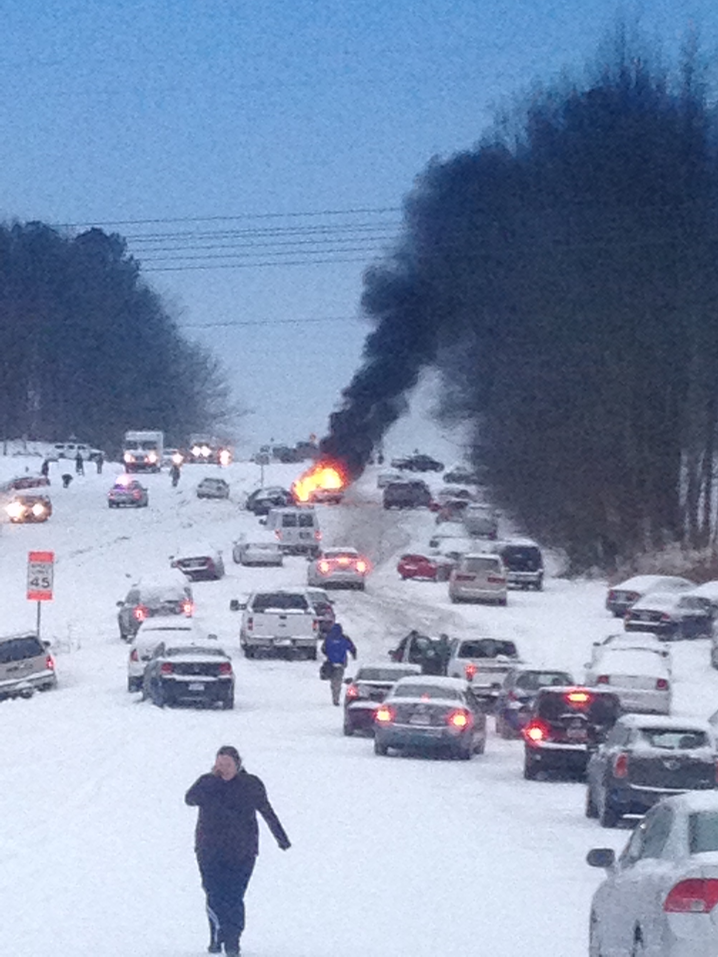
Icy roads in metro Atlanta brought traffic to a standstill. Source: Atlanta Journal Constitution
However, despite the dramatic change in the forecast, Atlanta area public school systems did not close and Government offices opened as scheduled. In the end, roads were never properly treated and as the snow began to fall at around 10am, tens of thousands of people poured out onto them all at once trying to get home. This created epic gridlock that trapped people in traffic for hours. Thousands had to spend the night in their cars. Others abandoned their cars and tried to walk home or sought shelter in nearby buildings. Children slept in buses or at schools. Good Samaritans took stranded motorists into their homes and local businesses generously offered shelter. A Chick-fil-A restaurant took free hot meals out to the adjacent interstate and offered it to those stranded. The traffic didn’t clear up until after sunrise the following morning. The exact same scenario played out in Birmingham as thousands were stranded on gridlocked, icy interstates. The crisis led to widespread criticism of leadership in both cities, who were caught completely unprepared by the relatively sudden change in the forecast, as well as NWS forecasters, and led to calls for sweeping changes in emergency response plans with respect to winter weather.
Accumulating snow was seen as far south as Monterrey, Mexico. Chicago saw its third snowiest January on record, with 33.7” and Mauna Kea, Hawaii saw a record snow event in late January with 12”. While the east remained bitterly cold, the west saw above-average warmth as persistent ridging remained in place. This ridging is what caused the steady stream of arctic air into the eastern US.
February
The cold temperatures continued into February. Numerous cities had their coldest February in decades, particularly in the upper Midwest. As the month began, 75% of the Great Lakes were frozen over, the lakes’ most substantial ice coverage at that point in the season in 18 years.

Famous Magnolia Lane at Augusta National Golf Club in Augusta, Georgia covered in snow, sleet, and ice. The club lost numerous trees, including the famous Eisenhower Tree.
Source: Atlanta Journal Constitution
Another major snow and ice event struck the south in the middle part of the month. Up to a foot of snow fell in parts of the Smokey Mountains and 8” fell in the Chattanooga area, while up to 5” fell in north Georgia. Meanwhile, a major ice storm struck a huge swath of central Georgia and South Carolina. 1.34 inches of ice accumulated at Warrenton, Georgia and neighboring sections of South Carolina saw nearly 1.5 inches of ice. This caused widespread power outages and scattered property damage from falling tree limbs. The famous Eisenhower Tree at Augusta National Golf Club, site of the Masters Tournament in Augusta, Georgia, was irreparably damaged and had to be cut down. Fortunately, however, the appalling gridlock of the January event just a couple weeks earlier was not repeated.

A surreal scene on an interstate near Raleigh as traffic ground to a halt and people abandoned their cars, one of which caught fire. Source: CNN
That same storm brought a major snowstorm to portions of North Carolina. Raleigh saw the same crippling gridlock that Atlanta and Birmingham saw in January. Roughly six inches of snow fell with near-whiteout conditions at times. Eight inches fell at Winston-Salem. The storm continued northward, dropping 15” on Baltimore and parts of DC (with areas of nearby Maryland reporting over 20”). Thirteen inches fell on New York City and 9” fell in Philadelphia, marking the Philadelphia area’s fourth 6”+ snowstorm of the winter, a new record.
Just a few days later, however, a moderate tornado outbreak struck portions of the Midwest and South. Particularly notable tornadoes struck near Fort Payne, Alabama and the north side of Dublin, Georgia. In all, the two day outbreak produced 46 tornadoes in 14 states.
Bitter cold again struck late in the month and continued into the first week of March. Flint, Grand Rapids, and Gaylord, Michigan; Green Bay, Wisconsin; and Toledo, Ohio all set daily record lows on February 28. Newberry, Michigan fell to a bonechilling -41F.
March
Relief from the cold was slow to come in March as temperatures remained below average for much of the lower 48. DC, and many areas of the northeast, including the entire state of Vermont, saw their coldest March on record. Flint, Michigan (-16F) and Rockford, Illinois (-11F) set monthly record lows on March 3.
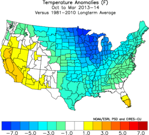
Observed temperature anomalies during the the Oct 2013-Mar 2014 period versus climate means, showing the bitter cold that gripped much of the lower 48. Credit: NOAA
The winter of 2013-2014 was historic in many ways. Chicago saw its coldest calendar winter on record. Between December 1 and March 31, the average temperature in the city was 22F, 10 degrees below average. Numerous other locations had among their top five coldest winters. Two thirds of the Great Lakes remained frozen over through the first week of April, a very rare occurrence, significantly impacting maritime commerce. By April 10, the high pressure ridge that had been parked over the Rockies finally shifted east, and the eastern two thirds of the lower 48 at last began to thaw.
While everybody east of the Rockies were shivering and buried under snow and ice, the west saw unusually warm and dry conditions. California had its warmest and third driest winter on record, and temperatures in Alaska were well above average. The warm, dry conditions adversely affected many western ski resorts. The Pacific Northwest, however, received significant snowfall courtesy of the numerous storms that poured in over the persistent ridge.
April
Tornado season got a late start courtesy of the bitterly cold winter. Just 27 tornadoes formed prior to April 25 outside of the February 20 outbreak, most of them weak. When an EF3 struck rural areas near Washington, North Carolina on April 25, it marked the latest first formation of an EF3 or greater tornado on record.

Devastating damage to the Parkwood Meadows subdivision in Vilonia.
Source: NOAA
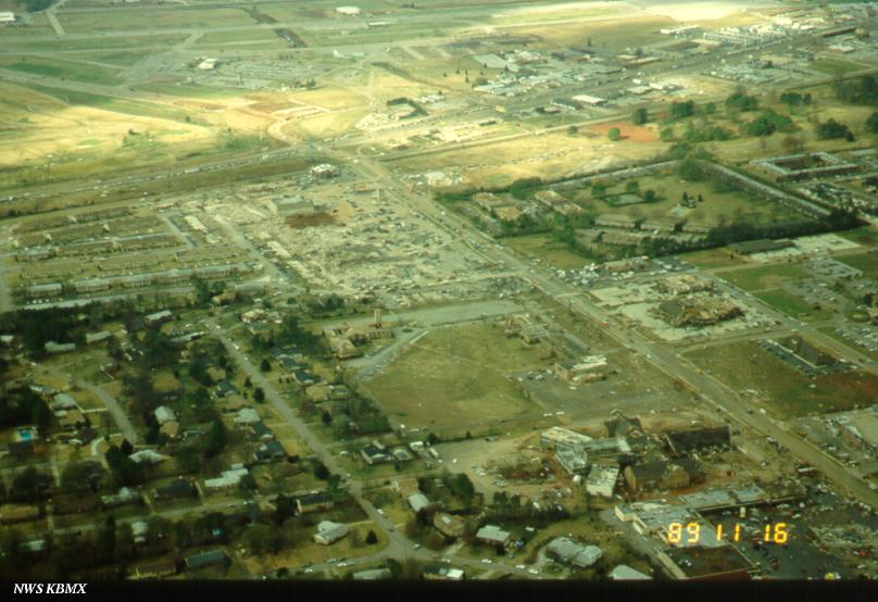
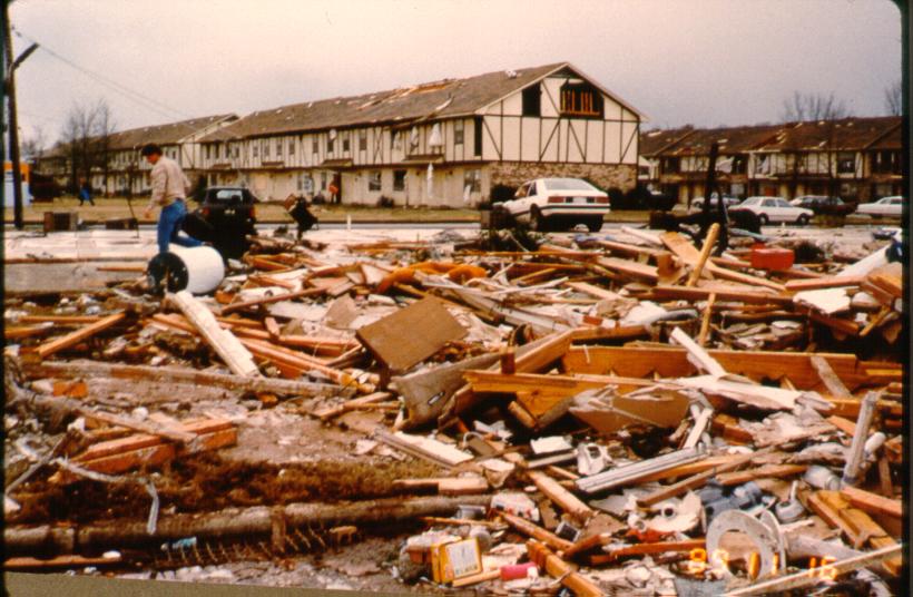
Two days later, the first significant outbreak of the season occurred. A powerful EF4 tornado devastated the town of Vilonia, Arkansas. It touched down six miles east of Paron and moved north-northeast, first causing major damage to subdivisions just south of Mayflower before ripping through Vilonia. The Parkwood Meadows subdivision was particularly hard hit, with nine poorly anchored homes completely wiped out. Numerous large commercial buildings were leveled. A 15-ton fertilizer tank was carried three quarters of a mile and one properly anchored home was completely swept away. These extreme shows of force are indicative of a tornado very near EF5 intensity, which this tornado likely flirted with and may have briefly reached. Sixteen people died. It was the state’s deadliest tornado since the Jonesboro F4 of May 15, 1968.

An obliterated home in Louisville.
Source: NOAA
Another EF4 struck Louisville, Mississippi. It formed in rural Leake County and moved northeast, passing northwest of Noxapater before curving more to the north-northeast, striking the southeast side of Louisville, causing devastating damage. Three large factories were destroyed and adjacent neighborhoods were ripped apart. Numerous homes were destroyed and a few were swept away. A door from Louisville was carried some thirty miles and dropped on the campus of Mississippi State University. Ten people were killed.
The storm also brought historic flooding along the central Gulf Coast. Some areas received as much as 26 inches of rainfall. Pensacola, Florida got 22” in just a single 24 hour period, including an astonishing 5.68” in an hour at one point. Widespread flash flooding occurred, including in the cities of Pensacola, Mobile, and Gulf Shores. $100 million in damage occurred in Pensacola alone.
Flooding also occurred in the mid-Atlantic states as up to 7.57” of rain fell. The entire Delaware River watershed saw flooding to some extent. In some areas, it was the worst flooding event since Hurricane Irene.
May-June
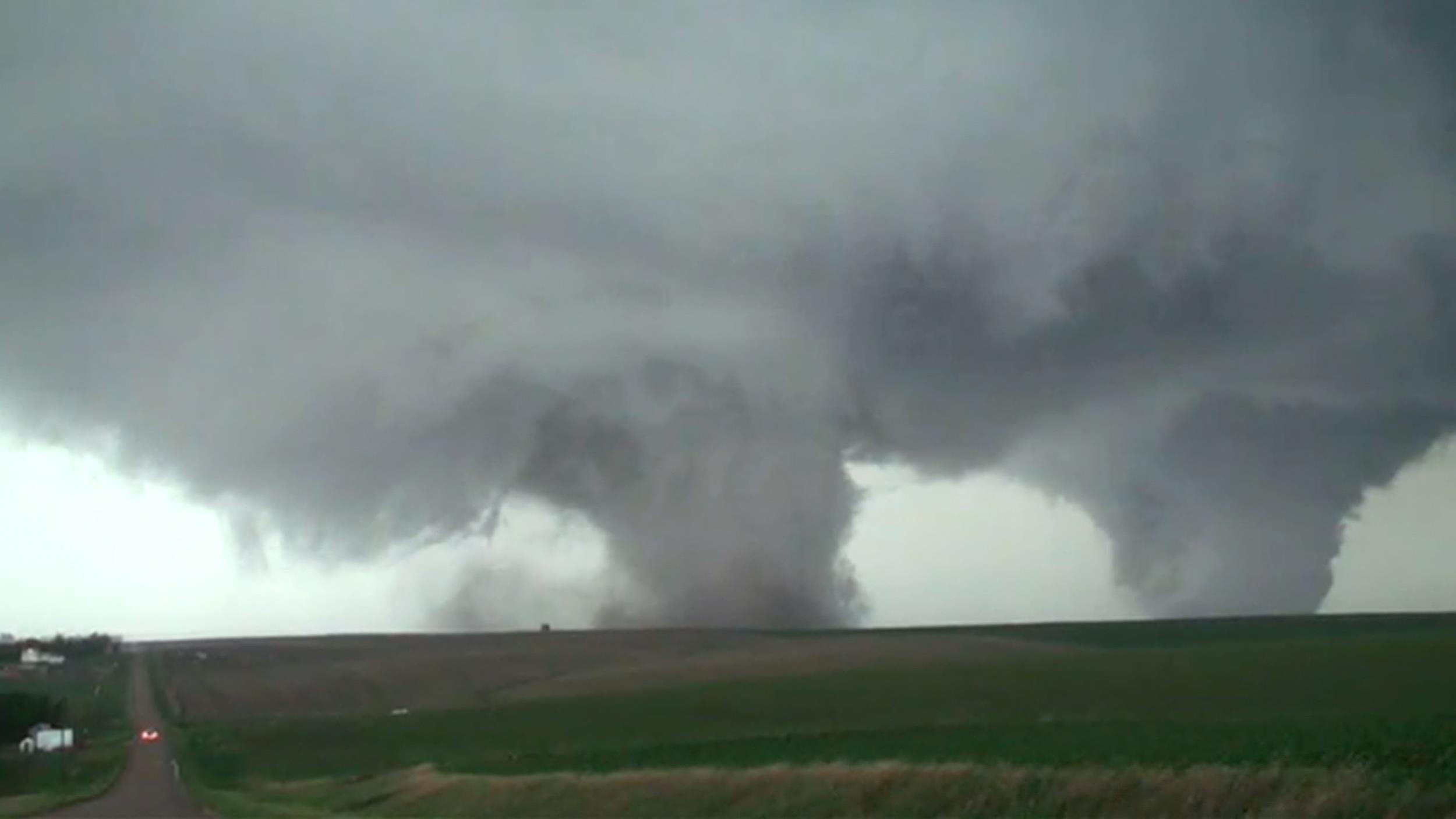
May was largely quiet. The San Diego area was hit by numerous wildfires, some of which were man-made. One person was killed. June saw the return of severe weather. On June 16, a major outbreak struck the northern Great Plains and the upper Midwest. A single supercell produced an astonishing four EF4 tornadoes. The first formed southwest of Stanton and moved north-northeast, passing west of that town as an EF3. The tornado intensified as it crossed US-275 just west of Oak Street, wiping out two farmhouses and throwing two vehicles over a quarter of a mile.

Incredible shot of the Pilger twin tornadoes taken by a storm chaser.
Shortly after that tornado lifted, another formed over rural areas east of Stanton and moved northeast. As it intensified, a third tornado formed alongside it about two miles to the east. The second tornado ripped through the town of Pilger as an EF4, causing widespread major damage, as its twin tore through neighboring farmland. Many homes and businesses in Pilger were destroyed, including some brick buildings, and some were swept away. After the second tornado passed Pilger, the two began to converge, eventually crossing paths as the third tornado also reached EF4 strength and turned to the north. The third tornado wiped out a farmhouse before lifting. As it weakened, yet another tornado formed. This one moved just east of due north and caused major damage to farms south and east of Wakefield. Several farmhouses were wiped out in the vicinity of 854th Road just east of Nebraska 16. Fortunately, just two people were killed by the four tornadoes combined.
Two days later, another EF4 struck rural areas of eastern South Dakota, wiping out a farm south of Alpena and throwing heavy machinery great distances. A corn field was stripped to bare soil.
July
The 2014 hurricane season was fairly quiet. However it had a somewhat exhilarating beginning. Hurricane Arthur developed from a non-tropical low on July 1 off the east coast of Florida and moved northward and then northeastward toward the coast of the Carolinas. By July 3, it was a Category 2 hurricane bearing down on the Outer Banks. With the Fourth of July weekend approaching, thousands of tourists had flooded local beaches. With Arthur bearing down, many of them fled and local holiday celebrations were cancelled or postponed all along the East Coast. More isolated barrier islands were ordered evacuated as ferry service would be cut off.

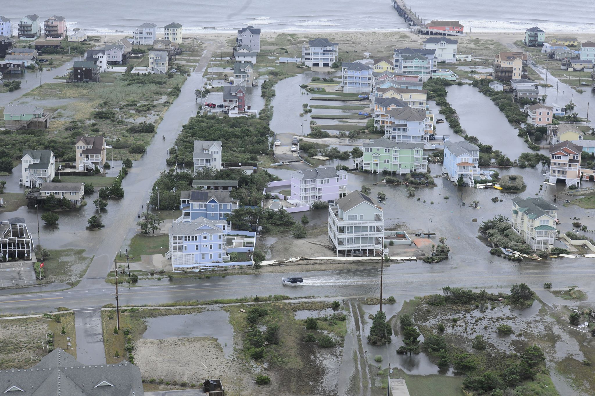
Coastal flooding in Rodanthe, North Carolina on Hatteras Island, one of the communities hardest hit by Arthur.
Source: United States Coast Guard
Arthur made landfall at Cape Lookout with 100 mph sustained winds, the worst of which remained offshore. A 77 mph sustained wind and a 101 mph gust was recorded near the point of landfall. Widespread flooding struck the North Carolina coast up to six feet deep in places, flooding some homes and businesses. Severe impacts, however, were avoided and no homes were declared a total loss. Roughly 44,000 customers lost power, which remained out in some areas for days. Portions of coastal New England were also affected as Arthur passed just offshore. Nantucket was hit with tropical storm force winds and some minor coastal flooding. Widespread power outages were reported in Maine, with only scattered outages in Massachusetts.
Arthur became extratropical shortly before striking Nova Scotia. Hurricane-force winds caused widespread major damage to power grids and utilities, with over 290,000 left in the dark. Damage came to a relatively minor $52.5 million and just one person was killed.
August

Several motorists were stranded by major flooding in the Detroit area. Portions of I-75 were shut down due to floodwaters up to five feet deep.
Source: Detroit News
While the Atlantic hurricane season was quiet, the Eastern Pacific was very active. During the first week of August, Hurricane Iselle, once a Category 4, took aim at the Hawaiian Islands. Fortunately, Iselle weakened to a 60 mph tropical storm before striking the Big Island on August 7. Gusts as high as 96 mph were reported at higher elevations. The storm brought torrential rains of up to 12 inches in some areas, causing widespread flooding that killed a hiker. Strong winds tore the roofs off of homes left nearly 22,000 people without power. 60% of Hawaii’s papaya crop was destroyed. Damage came to $66 million, making it the third costliest tropical cyclone in state history.
As people in Hawaii were cleaning up after Iselle, Michigan was getting hammered by torrential rains. Widespread flooding struck the Detroit area, leaving motorists stranded and roadways impassible. Portions of Interstate 75 were shut down due to floodwaters and numerous homes received at least some flooding.
September
In early September, Hurricane Norbert combined with the remnants of Tropical Storm Dolly in the Atlantic to create a major flood event in the desert Southwest. Norbert passed offshore of Baja California as a Category 3 and Dolly struck the Tampico area. The outflow of Norbert combined with Dolly’s remnants to spread torrential rain northward into the United States. Arizona was the hardest hit. Up to six inches fell in less than a day in areas that are normally exceptionally dry. Phoenix Sky Harbor Airport got 3.3” in just seven hours. The Phoenix area was inundated, with floodwaters as deep as 15 feet. Phoenix recorded a two hundred year flood event and some suburban areas recorded a thousand year flood event. It was the worst flooding in the state since 1970.

Historic flooding shut down interstates and flooded homes in the Phoenix area.
Source: social media
In southern Nevada, parts of Interstate 15 had to be shut down due to flooding and some cars were swept away. Two hundred children were trapped in an elementary school by floodwaters 12 feet deep. Road flooding also struck portions of New Mexico and California.
A week later, Hurricane Odile caused widespread major damage in the Baja California of Mexico. Its remnants caused scattered minor flooding in Texas and some minor coastal flooding in San Diego County, California due to wave action.
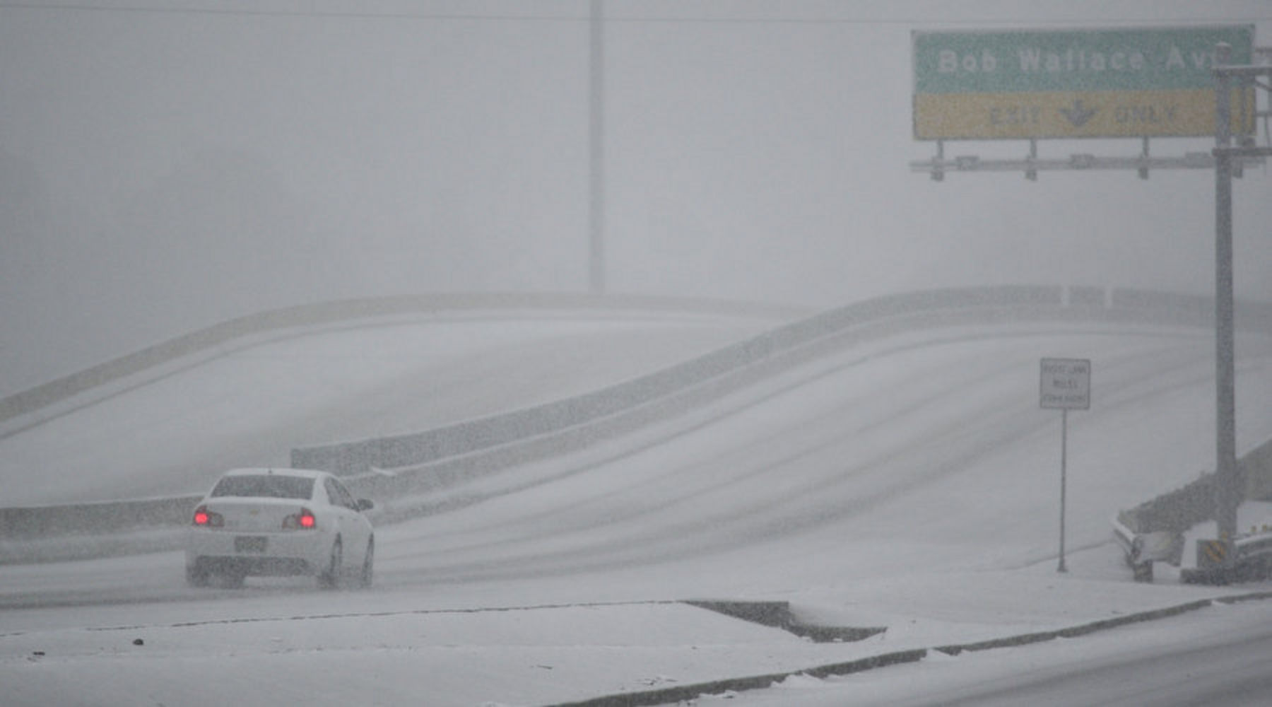
On September 10, a winter storm struck Montana and adjacent states, setting records for earliest snowfall in many spots.
October

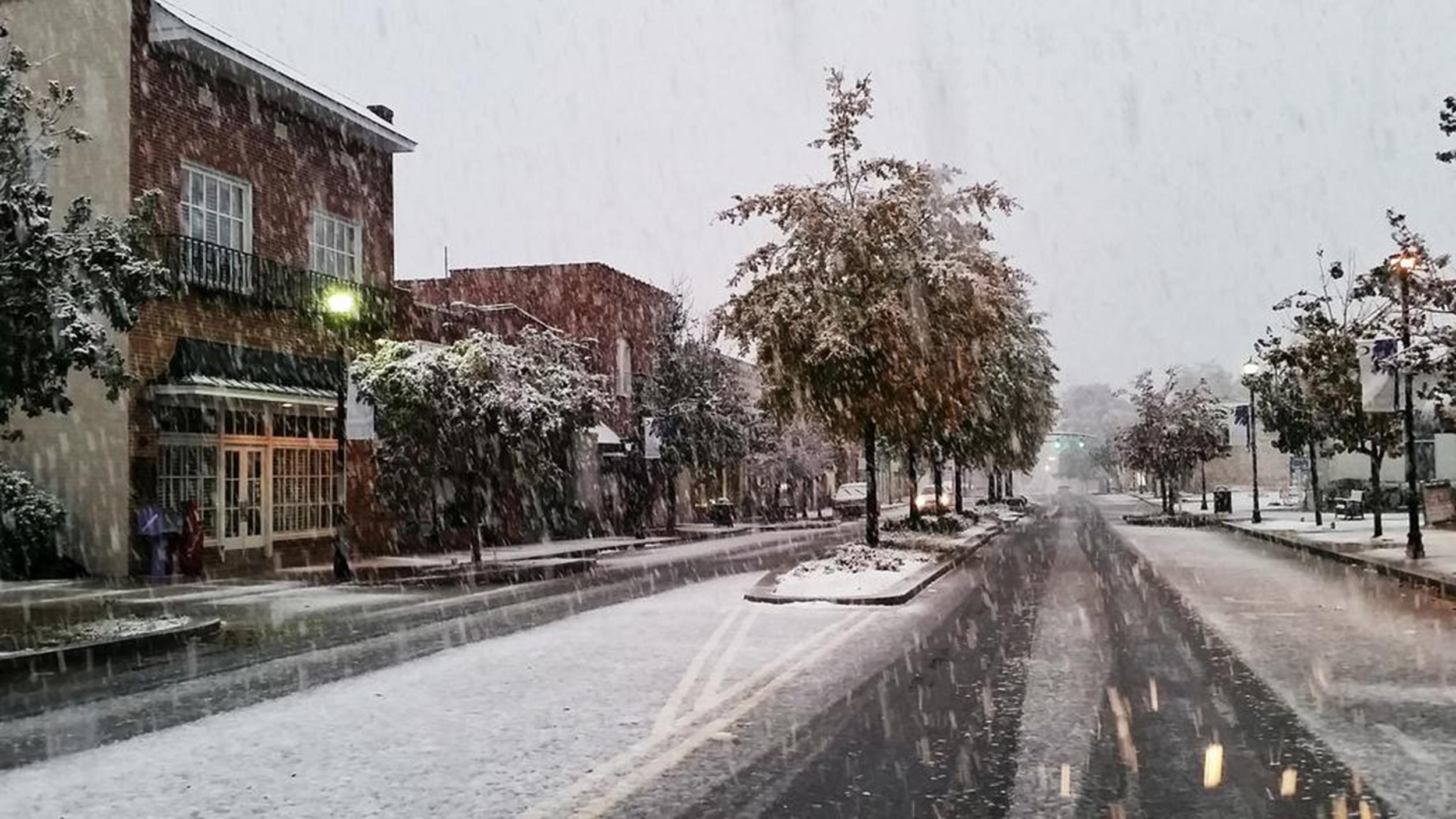
Snow in Lexington, South Carolina on November 1. This was a continuation of the southern snow event that began on Halloween night.
Source: social media
On October 17, Hurricane Gonzalo struck Bermuda as a major hurricane, causing major damage. Minor effects were felt in Puerto Rico and the US Virgin Islands as the hurricane brushed the Leeward Islands on October 13. At around the same time, another hurricane was threatening the Hawaiian Islands. Hurricane Ana passed just south of the islands on October 17 and 18 as a Category 1, bringing torrential rain to the islands of up to 11.67”. A water treatment plant on Sand Island on Oahu overflowed, sending 5,000 gallons of partially-treated wastewater into Pearl Harbor.
Late in the month, an early blast of winter struck portions of the southern Appalachians as a massive trough plunged southward. Snow fell in the Smokies and the north Georgia mountains on Halloween night, setting several earliest snowfall and daily/monthly snowfall records. This proved to be just a prelude of events to come.
November
The month of November was highlighted by a series of record-setting cold waves. The first struck early in the month and was a continuation of the Halloween event as unseasonably cold temperatures occurred across portions of the eastern US for the first week of November.
This was followed by a historic cold wave just a week later. It was spurred by the extratropical remnant of Typhoon Nuri, which evolved into a powerful non-tropical storm system that caused the jetstream to crash deep into the lower 48, bringing bitterly cold arctic air southward. Record lows were smashed across large swaths of North America. See my previous blog post for more in depth coverage of this event.
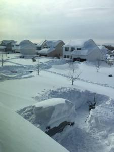
Incredible photo of a neighborhood in western New York buried by feet of lake effect snow.
Source: social media
During the latter part of the cold wave, a historic lake-effect snow event slammed the eastern Great Lakes region. Intense, convective snow bands struck regions around Lake Erie and Lake Ontario as a powerful storm system moved through the region. The Buffalo metro area was buried under as much as 65” of snow (5.4 feet). Nearby Bennington, New York recorded an astounding 88” (7.3 feet!), with larger drifts. Some homes were buried up to the eaves. Many were trapped in their homes and had to literally dig their way out. The Buffalo Bills and other sports teams were forced to postpone games due to the storm and the Bills ended up having to play their next home game against the New York Jets in Detroit. Some players had to be dug out of their homes and retrieved by snowmobile.
Later in November, yet another cold snap hit the northern Great Plains. The temperature in parts of Montana fell an astonishing 70F in a single 24 hour period.
Eighteen states had one of their ten coldest Novembers on record and the lower 48 saw its greatest November snow coverage on record, with over 50% of the country blanketed.
December

Widespread flooding in California was brought on by the Pacific “Pineapple Express” in December.
Source: AP
December saw the return of more mild temperatures for much of the US, a welcome relief after a bitterly cold and snowy November. However, on December 10, a major storm system struck the West Coast, bringing heavy snow and blizzard conditions to the western mountain regions and flooding rains to the lower elevations. Portions of California had their heaviest rainfall in years, with up to eight inches reported in a 24 hour period. This storm system fueled the steady pipeline of moisture known as the Pineapple Express as a high pressure parked itself over the Aleutians. This kind of blocking pattern causes a dip and elongation of the jetstream as persistent low pressure systems develop on the backside of the high pressure and funnel a steady stream of moisture from the warmer waters southeast of Hawaii northward into California. This rainfall helped break a substantial drought that had mired portions of the western US, particularly California, for most of the year. The event finally subsided by December 21. Another smaller and shorter event struck over the Christmas holiday.
All was quiet as the year came to a close, but what an eventful year it was. It’ll be interesting to see what 2015 has in store.