It’s cold out there! Really cold. Yesterday morning was the coldest November morning in the lower 48 in 38 years. This marks the third major cold outbreak of the season thus far. The first occurred on Halloween. Chicago received it’s earliest snowfall since 1993 and parts of the Great Lakes region failed to get out of the 30’s. Meanwhile, an unprecedented snowfall struck the southern Appalachians. Asheville, North Carolina received five inches of snow on Halloween night. Asheville had never had any more than flurries on that date. Other areas of the Great Smoky Mountains received up to 22 inches. Parts of north Georgia received their earliest snowfall on record. Temperatures across the eastern half of the US were, on average, 10-15 degrees below normal.
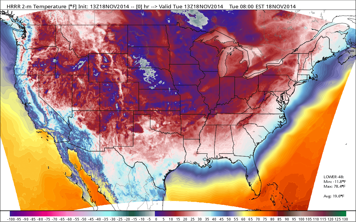
A map of near-surface temperatures at 8 am Eastern Time Tuesday morning.
Source: WeatherBell
The second major cold snap began ten days later. The temperature in Omaha dropped 41 degrees in less than 24 hours, from 60F at 11:40 am on November 10 to 19F at 7:05 am on November 11. The high in Denver on November 12 was just 6F, the city’s coldest high for so early in the season. Only three other November days on record were colder in Denver. Amarillo, Lubbock, and Childress, Texas along with Goodland, Kansas all had record cold high temperatures that day. Casper, Wyoming plunged to -27F just before midnight and stayed there into the following morning. The city’s previous November record low was -21. Parts of the northern Great Plains barely reached 20 degrees and freezing temperatures reached as far south as the central Gulf Coast region. Some Minnesota ski resorts were able to open early thanks to the early season snowfall and persistent cold temperatures.
Just a few days later, another blast of cold air surged into the lower 48. On Monday, the temperature in Kansas City failed to get above 23F, a new record; and Joplin, Missouri dipped to 6F the following morning, a record low for the month of November. Dallas saw highs of 45F or lower for five consecutive days, between November 12 and 17, for the first time ever. Yesterday morning, it reached -12F in Valentine, Nebraska; and 10F in Paducah, Kentucky…both records. 85% of the lower 48, encompassing roughly 226 million people, experienced freezing or sub-freezing temperatures yesterday. Portions of all 50 states reached or fell below the freezing mark. Temperatures east of the Rockies were as much as 40F below normal. Last night, temperatures dipped into the single digits in parts of the northern Great Lakes and fell into the twenties all the way to the northern Gulf Coast. Charlotte, North Carolina bottomed out at 14F, a record for so early in the season. Portions of central Alabama saw lows in the teens, setting new records.
Meanwhile, a massive lake effect snow event slammed the eastern Great Lakes, particularly western New York. Buffalo was buried under an astonishing five plus feet of snow, trapping people in their homes and bringing a city accustomed to heavy snow to a screeching halt.
While relief is now on the horizon and a warm up is expected by the end of the week, the way the season has gone so far does make you wonder how long it will last…and what January will look like.
Here’s a great article from WeatherBell about this incredible cold snap with beautiful, illustrative maps: http://models.weatherbell.com/record.php
