In A Blink, Their World Vanished
(cont’d)
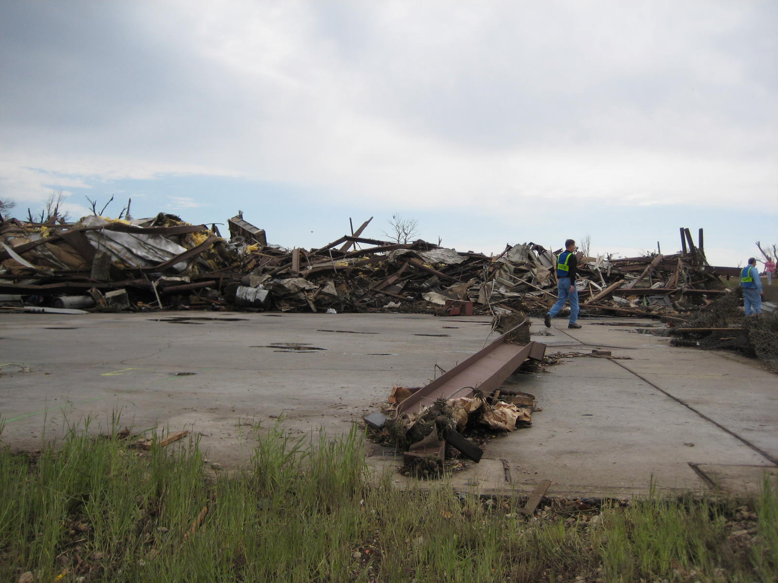
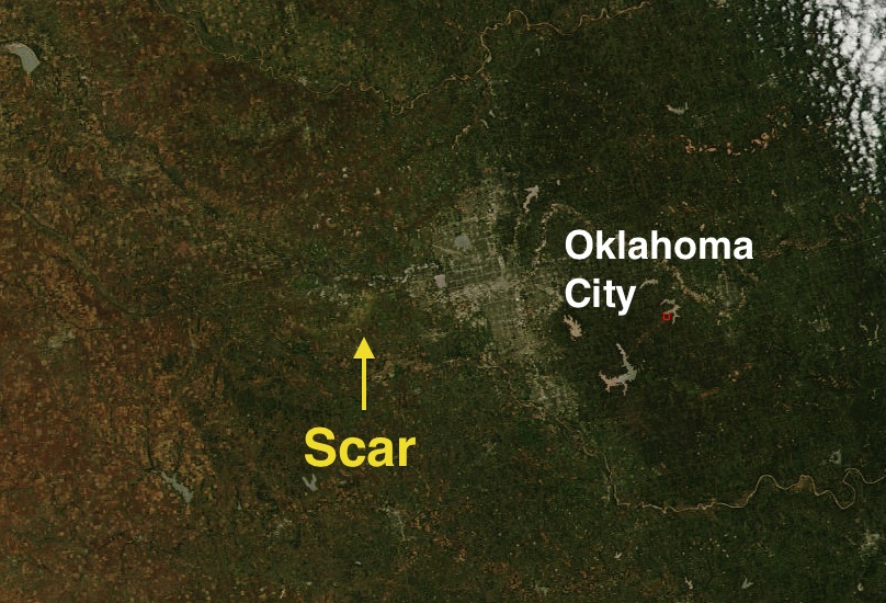
Franklin, Kansas – May 4, 2003
May, 2003 was the most active tornado month in recorded history with over 400 tornadoes touching down across the United States. By far the most prolific day was May 4, with 86 tornadoes, including four that were of at least F4 intensity. A deep low pressure system was moving through northeastern Kansas and a warm front had shifted north into north-central Missouri, bringing a very warm, moist, unstable air mass over eastern Kansas and western Missouri. Ahead of the cold front, a dryline (see the Lubbock entry for a description of a dryline) was pushing into eastern Kansas, generating substantial lifting. These conditions led to a major outbreak of severe weather that day.

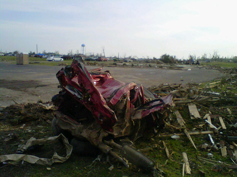
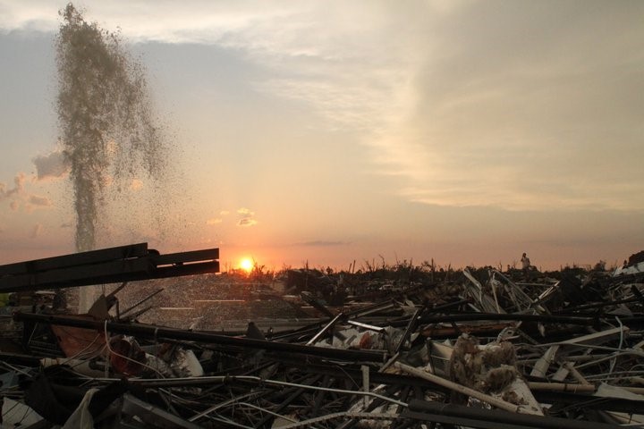
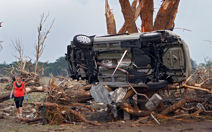
A view of the tornado passing south of Girard.
Credit: NOAA
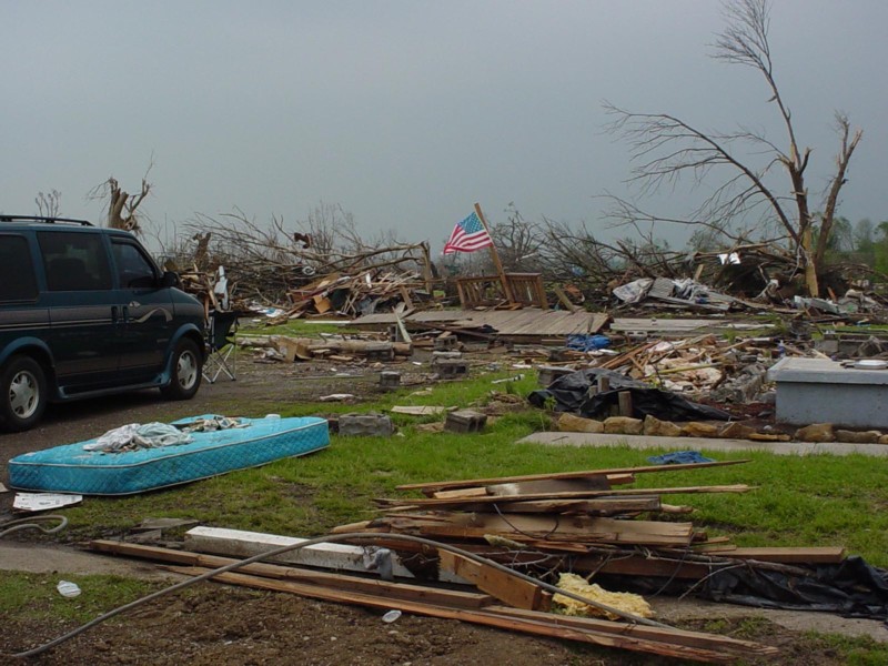
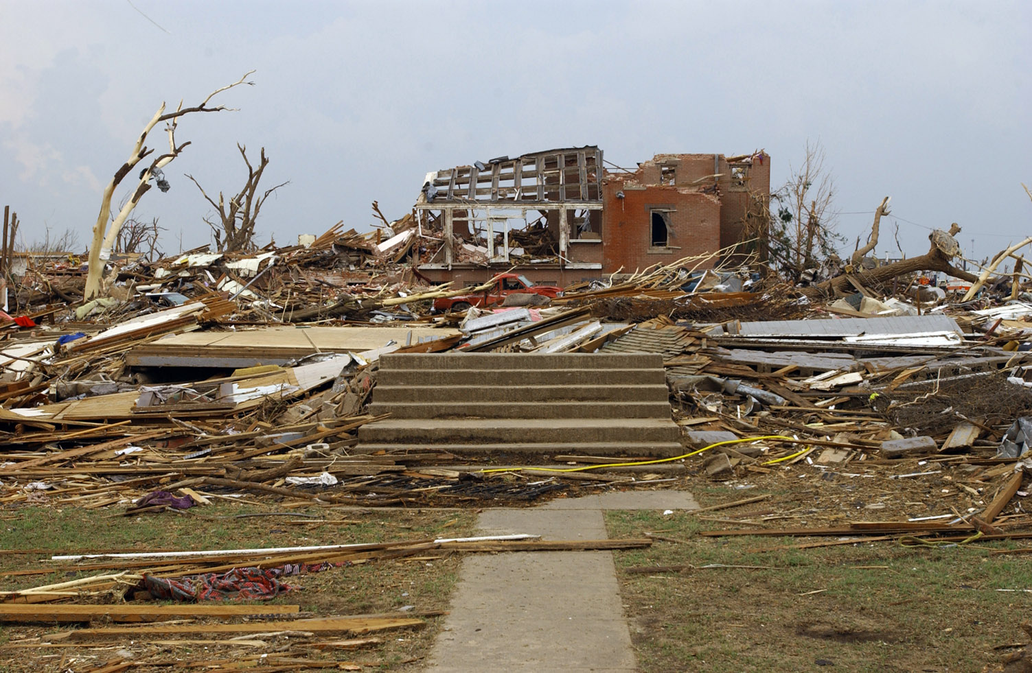
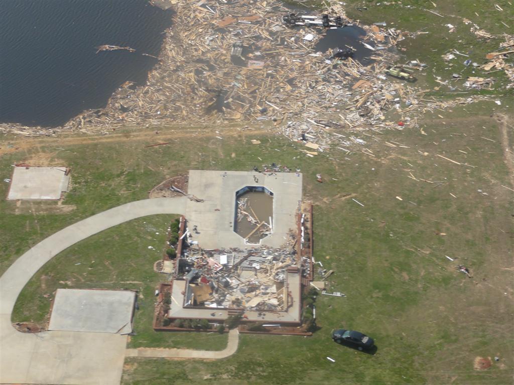
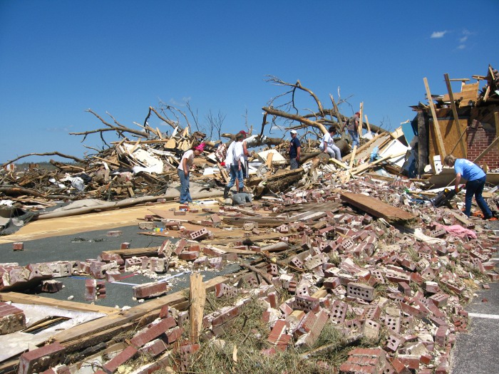
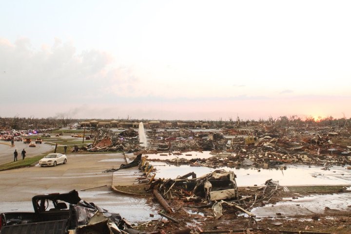
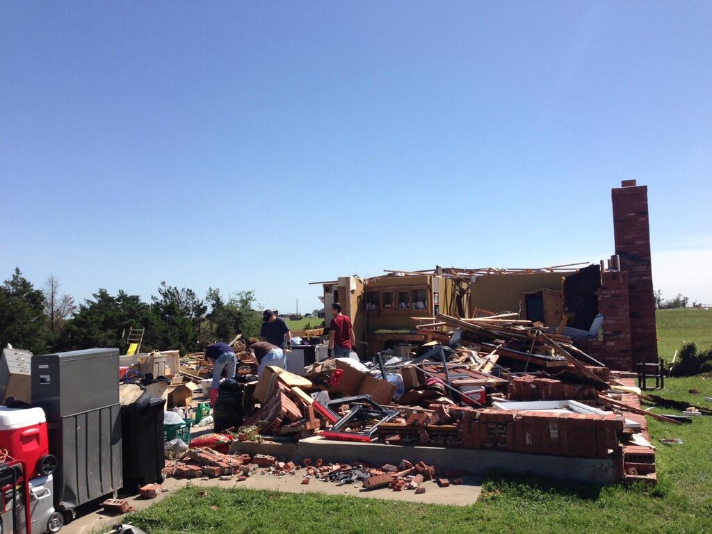
At around 4:30 pm, an F4 ripped through Kansas City, Kansas, destroying numerous homes and killing two people. Just minutes later, another tornado touched down in southeastern Kansas near the Neosho River northeast of Parsons and moved northeast. Crossing into Crawford County, the tornado quickly began to intensify. It passed south of Girard as a strengthening F2, but by the time it reached Ringo, it was at least an F4 a quarter of a mile wide. Several homes near Ringo were destroyed and some were completely swept away. Cars were thrown over a hundred yards through the air and pavement was torn from rural roads. Grass was scoured from the ground and significant disruption of topsoil occurred. The now half mile wide tornado then slammed into the village of Franklin, south of Arma. The town was virtually obliterated. The majority of homes were destroyed and a few were swept clean from their foundations. Three people were killed here.
A swept away home in Franklin.
Credit: franklinkansas.com
Passing south of Mulberry, the tornado derailed a freight train before moving into Missouri, lifting near the town of Liberal. A total of four people were killed, three in Franklin, and one in Missouri, and thirty more were injured. Dozens of homes were completely destroyed and numerous others were heavily damaged. This tornado was officially rated F4, however several meteorologists (including Gino Izzi, a senior meteorologist with NWS Chicago, and Oklahoma grad and storm chaser Simon Brewer) believe the damage warranted an F5 rating. The same supercell would immediately produce another tornado, a high-end F3 that caused heavy damage near Stockton, Missouri. While the Franklin tornado was in progress, a brief F4 spawned by the same storm that generated the Kansas City, KS tornado struck the Kansas City, MO suburb of Gladstone. Later that day, another violent tornado devastated Jackson, Tennessee, killing eleven. And just four days later, an F4 struck Moore, Oklahoma, causing widespread major damage. The terrible tragedy of four years before, however, wasn’t repeated. Not a single person lost their life.
Harper, Kansas – May 12, 2004
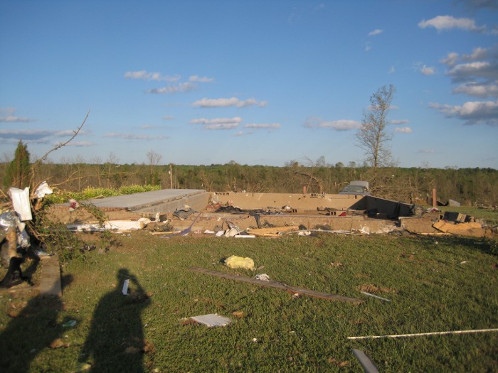
This was the site of the farmhouse that literally vanished. The family that lived here supposedly survived on that park bench in the foreground in the basement of the farmhouse. Note the shredded remnants of the trees that once shaded the house.
Credit: JR Hehnly
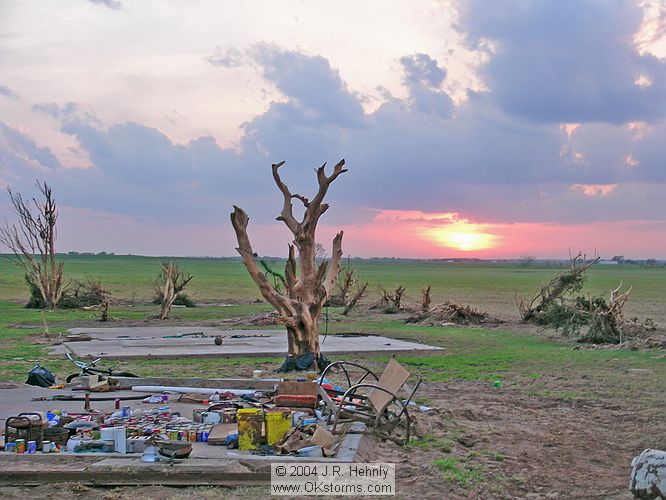
Across the vast emptiness of the Great Plains, there have undoubtedly been many monstrous tornadoes that reached F5 intensity and we’ll never know about them. However, modern science has made it harder for these tornadoes to hide. The VORTEX team in 1995 became the first to rate a tornado F5 based almost exclusively on scouring patterns. Mobile Doppler radar units are being deployed every spring to chase and directly measure the winds inside these tornadoes. Scientists don’t universally agree on these methods. And over the years, the National Weather Service has also been extremely reluctant to rate a tornado F5 based upon a single data point. However, what happened on a farm over open country south of Harper, Kansas that day almost defies belief.
The Harper tornado was part of a localized outbreak across south central Kansas that has since been overshadowed by the massive, devastating series of outbreaks across the Great Plains that began just ten days later. That event included the spectacular Hallam, Nebraska tornado that, at 2.5 miles wide, was the largest tornado ever reliably documented. Everyone pretty much forgot about Harper.
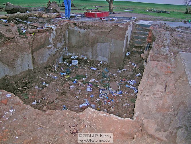
The empty basement of the eviscerated farmhouse. Some cleanup has already taken place. This basement was originally filled with debris.
Credit: JR Hehnly
At 7:32pm, a small, weak tornado touched down four miles south of Harper and moved northeast, doing nothing. Eight minutes later, the tornado lifted and reformed and exploded into a monster roughly half a mile wide. It struck a small farm three miles southeast of Harper and wiped it from the face of the earth. Despite being bolted to its foundation, the large, two-story farmhouse simply vanished. Even the debris was gone. Most of the time, when a house is swept away by a tornado, the remains of the home will be left in a pile nearby. Here, hardly a scrap of debris could be seen for miles in any direction. There was evidence of damage to the basement walls. Large pieces of heavy machinery were never found. Five cars on the property were ripped to pieces and scattered across the surrounding fields. Very little of the cars was ever found. One of the engine blocks was left in the basement of the farmhouse, now just a hole in the ground filled with what little was left of the house. Two other engines were found in the adjacent countryside. Several trees around the farmhouse were shredded and debarked. Some were pulled from the ground and carried away. Severe ground scouring occurred throughout the area and what was once a grassy field had been turned into a mud pit.

This is all that’s left of a Chevy truck that was on the property. The engine block was left in the basement of the farmhouse. Four other vehicles on the farm were equally obliterated.
Credit: JR Hehnly
The tornado lifted shortly after passing the farm. It had traveled just a mile and a quarter. The survey team from NWS Wichita conservatively rated the tornado F4 because the tornado was very slow moving and that may have contributed to the extreme damage. The survey team also had only a very small damage path to go off of because the tornado only traveled a single mile over open farm country. However, meteorologist Chance Hayes, who was a member of the original survey team, would later express regret over the conservative rating. Because the tornado ultimately had very little impact and was all but forgotten within a couple of weeks, there was never any push within the scientific community to revisit the rating. Other events, like the 2013 El Reno tornado, had a much greater societal impact, scientific value, and public interest and therefore there was a much greater desire to study them further.
Miraculously, the family that lived on that farm survived in the basement of the vaporized farmhouse with only minor injuries, somehow avoiding all the heavy debris that was thrown into the basement by the tornado. No one was killed in the tornado.
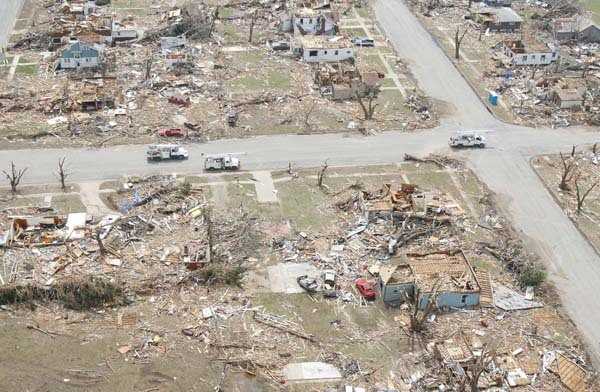
Greensburg, Kansas – May 4, 2007
Save for the 2003 outbreak, the tornado seasons of the early 2000s were remarkably quiet. 2005 had just a single violent tornado, the fewest total in the modern era, and 2006 had just two. It was the most inactive two year stretch in recorded history. In the meantime, meteorologists were refining the old Fujita scale. The Enhanced Fujita Scale was introduced in February, 2007. It incorporated more accurate wind estimates for each category and refined the damage criteria. It also made the F5 category unbounded. No more talk of a mythical “F6”. It would soon be put to good use. Mother Nature was about to break her silence.
Aerial view of the destruction.
Credit: John Vstecka
Greensburg, Kansas was at the time a modest town of about 1,500 people. It is the county seat of Kiowa County and lies just a few miles down the road from Mullinville, which had its own (less destructive) F5 in 1915. The day’s events would change Greensburg forever. It was four years to the day since the Franklin tornado and eight years and one day since the Moore tornado, the last officially rated F5. A low pressure system had stalled over the High Plains, and warm, moist, unstable air streamed northward into the southern Plains. At the same time, similar to the 2003 event, a dryline was moving through eastern Colorado into western Kansas. These provided ideal conditions for supercell development.
A destroyed house in Greensburg. The brick home behind it has also been severely damaged.
Credit: accesskansas.org
The day remained quiet, however, until sundown. A supercell had moved up from the Texas panhandle and was gaining strength. The tornado touched down over rural Comanche County northwest of Coldwater at around 9pm and moved north-northeast into Kiowa County. The tornado rapidly grew into a monster. On farms south of Greensburg, embedded pivot sprinkler systems used for irrigation were pulled from the ground and destroyed. Storm chasers reported multiple satellite tornadoes swirling around the main funnel in the ever increasing darkness.
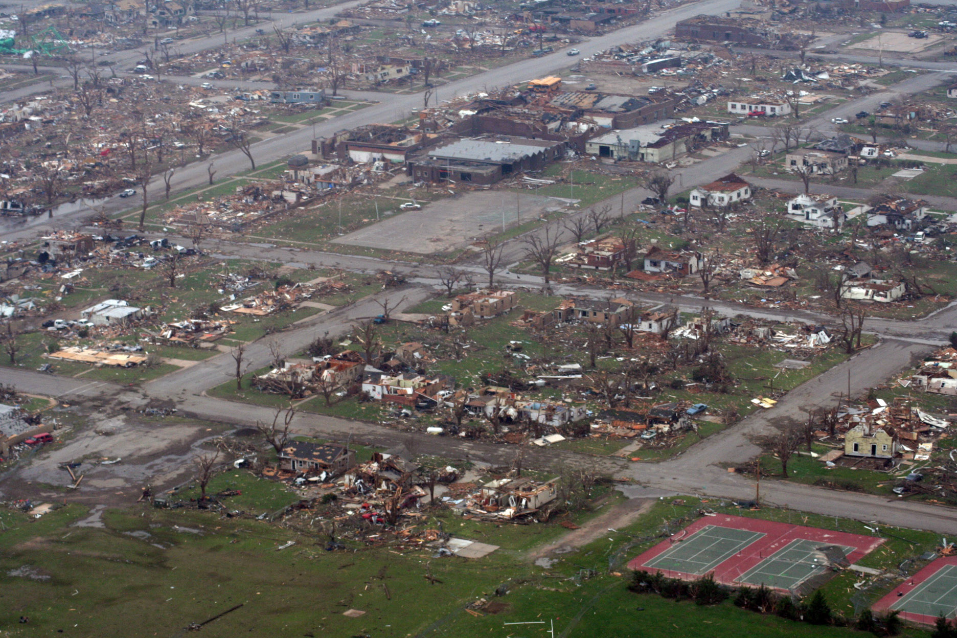
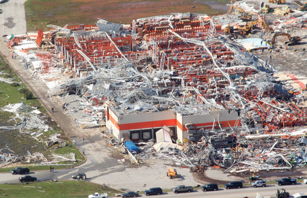
By 9:40 pm, the tornado was a mile wide and it was headed right for Greensburg. The National Weather Service office at Dodge City issued a tornado emergency for Greensburg. Tornado sirens went off and police officers went through the streets sounding their sirens. People heeded the warnings and scrambled for basements and storm shelters. The tornado slammed into Greenburg just minutes later. It was an F5 an incredible 1.7 miles wide. Greensburg was obliterated. 95% of structures were leveled and some homes simply vanished. Cars were thrown hundreds of yards through the air. The town’s water tower was toppled and destroyed. Fire hydrants were pulled from the ground and carried away. Kiowa County Memorial Hospital was heavily damaged, but all inside were unharmed. City Hall and Greensburg High School were among the buildings destroyed.
An example of the extreme damage in Greensburg.
Credit: Wichita Eagle
On the edge of town, several large oil tanks were destroyed. Also, several train cars, including a tank car carrying 14,000 gallons of ammonia, were derailed. This created significant environmental concerns. However, all hazardous materials were contained. Passing north of town, the tornado weakened and executed a full loop before dissipating. The same cell later produced three massive F3 tornadoes that raked through rural areas of western Kansas. One was over two miles wide, another was a mile and a half wide. In all, twelve tornadoes were associated with the Greensburg cell. The complex evolution of this cell has been the subject of considerable study.
Miraculously, just eleven people died, one of which was several months after the tornado. The devastation was so great that first responders requested three freezer trucks, thinking there would be hundreds of fatalities. Timely warnings and a vigilant and prepared public prevented a major human catastrophe. Some of those killed were in basements and had done everything they could to protect themselves. The tornado was so powerful that, without a reinforced storm shelter, there simply wasn’t anything they could’ve done. Just 63 people were injured. The vast majority of the town’s 1,500+ residents escaped unscathed, a simply remarkable result.
Debris removal took months. In all, an estimated 400,000 cubic yards of debris was removed. There was so much debris that the main highway through Greensburg (US 54/400) was closed for a month and the military was called upon to assist. Following the tornado, Greensburg was rebuilt as a “green city” with all buildings built to LEED platinum standards, the first such town in the US to do so. However, the town’s population has yet to recover. Its population at the 2010 census was roughly half of what it was at the 2000 census.
Elie, Manitoba – June 22, 2007

This spectacular image was taken looking northwest as the tornado approached Elie.
Credit: Justin Hobson
Violent tornadoes are relatively rare in Canada, but they do happen. On July 31, 1987, an F4 devastated portions of Edmonton, Alberta, killing 27 people. It was Canada’s second deadliest tornado in history (one short of the Regina tornado of 1912). There has been considerable debate as to whether or not it was an F5. After much consideration, it was left off this list. Of the two other Canadian F5s on this list, there is considerable uncertainty with regards to the 1935 Benson, Saskatchewan event. The other is a tornado that hit Frobisher and Alameda, Saskatchewan in 1920. However, Canada had never had an F5 tornado in the modern era. At the time, the most recent violent tornado in Canada was the one that hit Birtle, Manitoba in 1994.

Some of the most extreme damage in Elie.
Credit: extremeplanet
A slow moving low pressure system was moving through Saskatchewan and a cold front was moving into western Manitoba. Also a lake breeze front formed south of Lake Manitoba. Small scale front-like features can form near large bodies of water (such as oceans or large lakes) due to dramatic temperature differences between land and water. These act as additional sources of lift for storm formation. The tornado touched down just north of the Trans-Canada Highway a few miles northeast of the village of Elie at around 6:30 pm and moved southeast. It rapidly exploded into a powerful but narrow stovepipe tornado.
It moved very slowly and struck Elie some time later. Video taken of the tornado shows a two story house being lifted 75 feet in the air and destroyed. A panel van was picked up and thrown several hundred feet. Several homes were destroyed and at least two were completely swept away. A nearby flour mill was also destroyed. The tornado lifted shortly after passing Elie. It was on the ground for forty minutes but traveled less than four miles. Fortunately, thanks largely to advance warning, no one was killed. This was the first tornado to be officially rated F5 by Environment Canada, the meteorological service of Canada. Environment Canada still uses the old Fujita scale, hence the F5 instead of EF5 rating.
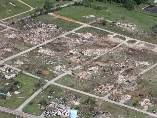
Parkersburg, Iowa – May 25, 2008
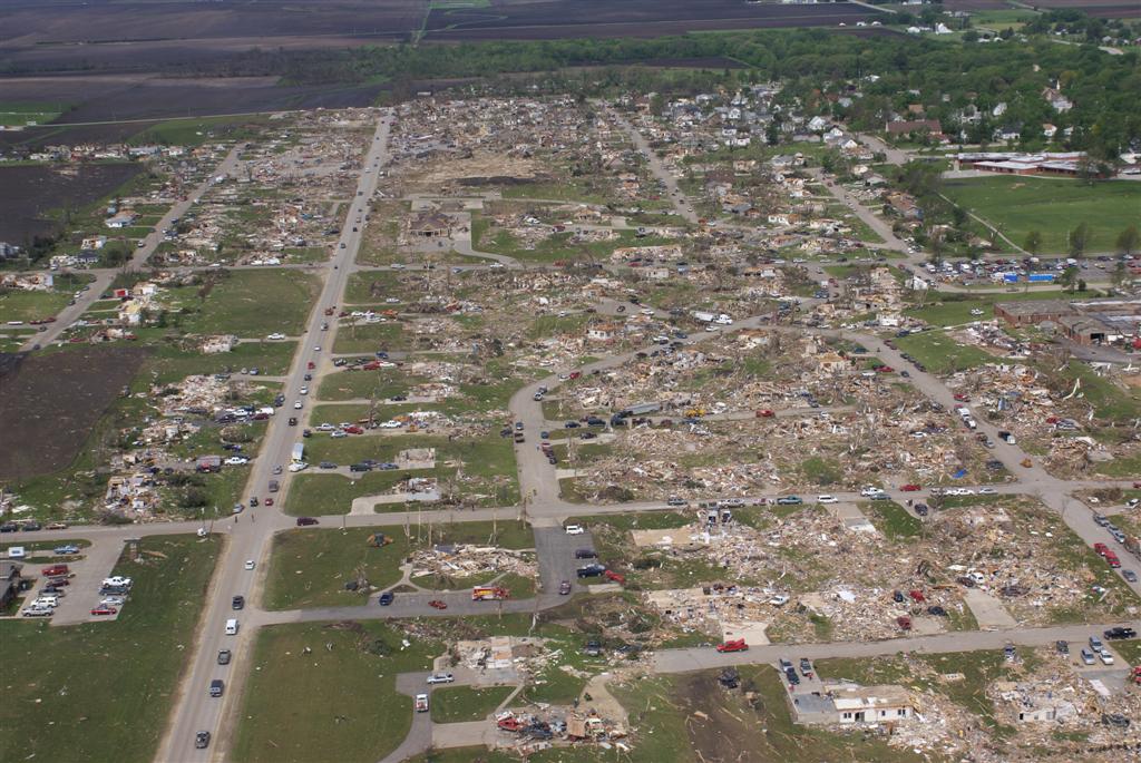
An aerial view of the devastation, including some swept away homes.
Credit: P&N Aerial Photography
Parkersburg, Iowa is a quiet rural town of about 2,000 people in Butler County in the northeastern part of the state. Iowa hadn’t had a violent tornado in nearly a decade and no tornado had killed more than three people in the state since 1978. The Parkersburg tornado was part of a series of outbreaks toward the end of what was a very active May. A low pressure system was moving through the Dakotas and warm, moist, unstable air was streaming northward into the upper Midwest. Tornadoes began touching down in Iowa and Minnesota almost simultaneously. At 4:35 pm, an EF1 struck the Minneapolis suburb of Coon Rapids.
One of the many homes that was swept away.
Credit: NOAA
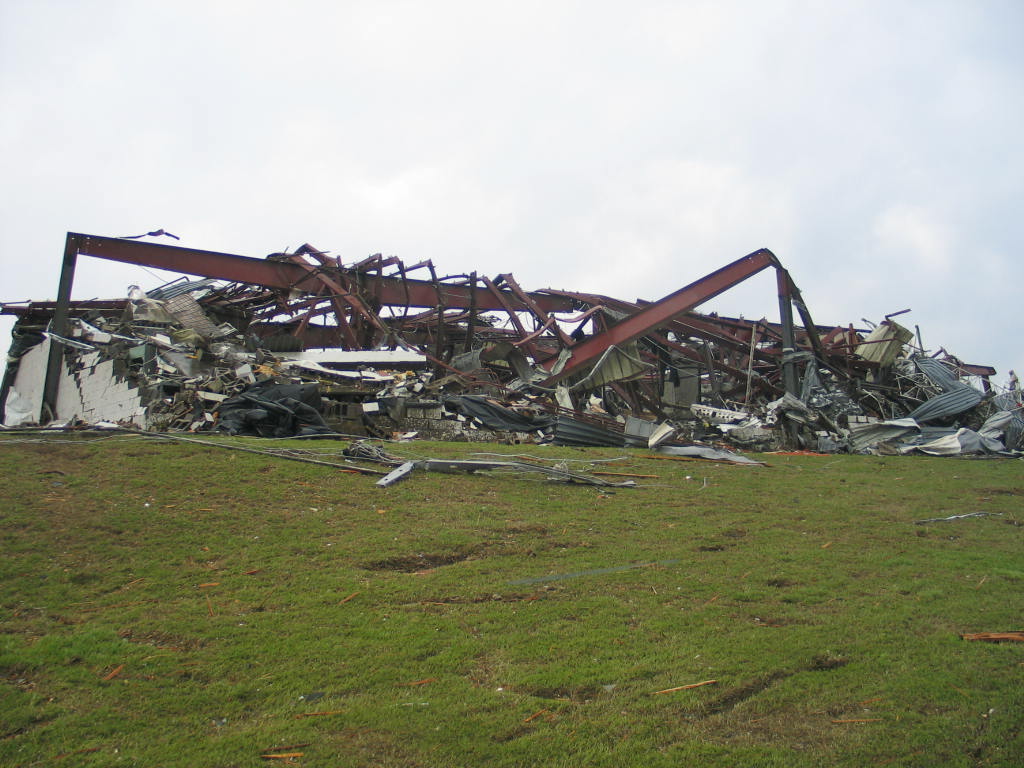
Just thirteen minutes later, another tornado touched down south of Aplington, Iowa near the Grundy County line and moved just north of due east, quickly intensifying. It ripped through the south side of Parkersburg as a three-quarter mile wide EF5. Rows of homes on either side of Johnson Street were annihilated. Numerous homes were completely swept away. Trees were completely debarked and shrubs were partially pulled from the ground. An industrial, steel-frame warehouse at the intersection of 6th Avenue and Highway 14 was completely leveled. Some of the steel beams were twisted and mangled by the force of the winds. Two newly-built homes along Newell Avenue simply vanished. Hardly a scrap of debris remained. Seven people died in Parkersburg, some of them in basements.
This industrial warehouse was completely leveled and partially swept away. Note the crumpled steel beams in the background.
Credit: NOAA
Moving east of Parkersburg, the devastation continued. The tornado ripped through a subdivision just north of New Hartford. Well-built homes were wiped from the face of the earth. Some were so obliterated that very little debris remained. Debris was pulverized into little more than wood chips and carried away. The concrete basement walls at one home buckled and partially caved in. Vehicles were thrown hundreds of yards through the air. Some of them were stripped to the steel frame. Others were smashed to pieces or destroyed beyond recognition. Two people were killed here, a number greatly reduced by advanced warning. Lightweight debris from Parkersburg and New Hartford was found over a hundred miles away.
The tornado weakened as it crossed into Black Hawk County, passing north of the twin cities of Cedar Falls and Waterloo. Though weaker, the tornado actually began to grow in size, eventually reaching 1.2 miles wide as it passed north and west of Dunkerton, curving more to the northeast. Extensive damage to farms occurred in this area. The tornado lifted shortly before reaching Fairbank. Its parent supercell immediately spawned another tornado, an EF3 that caused heavy damage in the town of Hazelton, just four miles south of Oelwein, which was devastated by its own F5 in 1968. The cell later produced a third tornado, an EF1.
In all, nine people were killed by the Parkersburg tornado, one of which occurred several months after the tornado, and seventy more were injured. Over 200 homes were destroyed in Parkersburg alone.
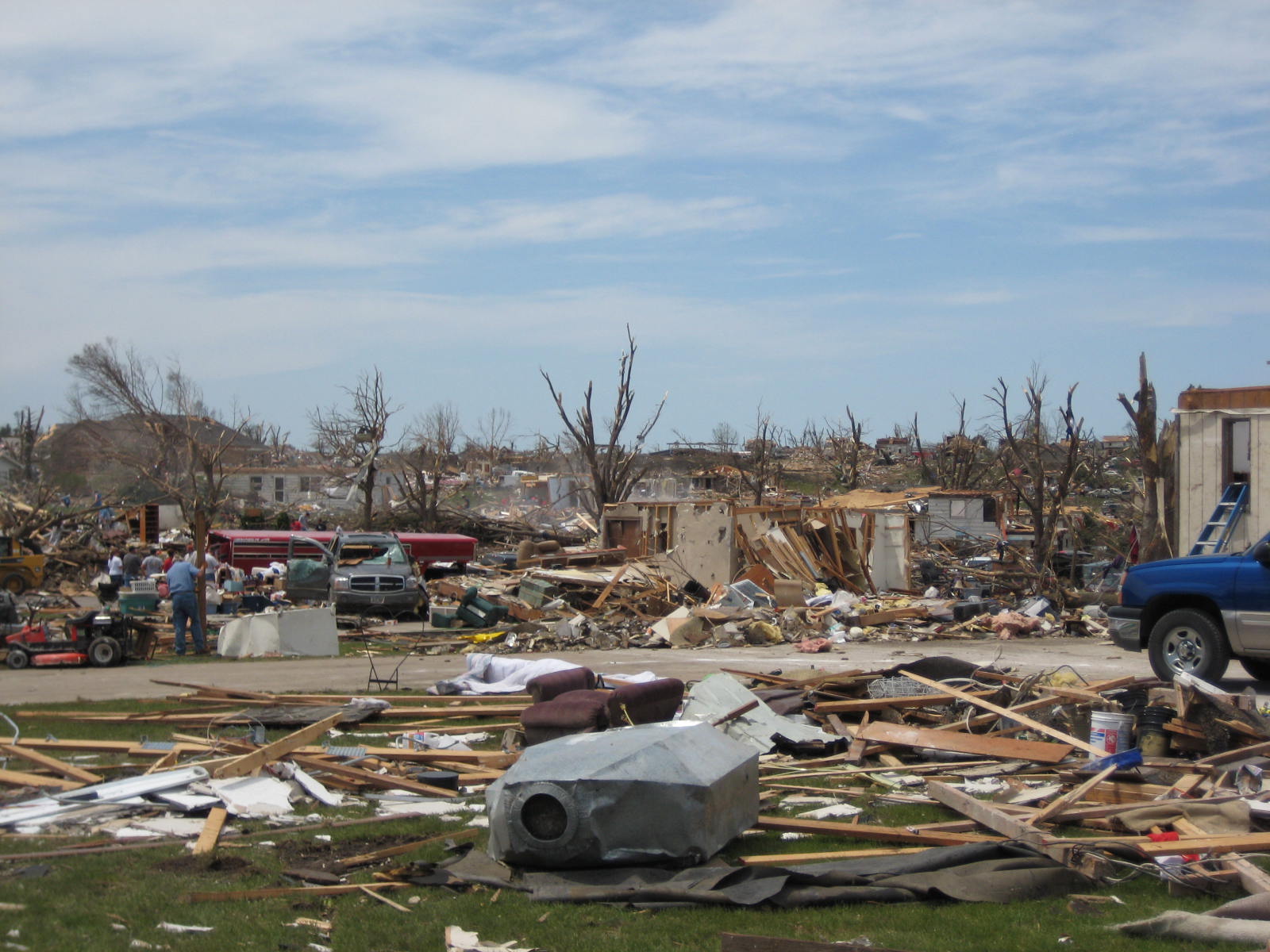
Prince Chapel, Mississippi – April 27, 2011
For nearly four decades, the Super Outbreak of 1974 stood alone as the greatest tornado outbreak of all time. It was an event that defied belief and assumed an almost mythical character. Its records were viewed by many as unbreakable, some of them arguably unapproachable. However, on April 27, 2011, it happened again. It was a warm, humid day in the Deep South. A deep low pressure system was digging into the Ohio and Tennessee River valleys. Warm, moist, unstable air was streaming northward ahead of the surface cold front. The jet stream was roaring over the Tennessee Valley, generating enormous amounts of wind shear. CAPE values (see the Plainfield section for an explanation of CAPE) were in excess of 2000 J/kg across Mississippi and Alabama.
An obliterated brick home in Kemper County.
Credit: NOAA
Another popular measurement meteorologists use to determine tornado potential is called helicity. Helicity gives us an idea of how likely rising air within a thunderstorm will begin to rotate. A rotating updraft is essential to tornado development. The higher the helicity, the more likely thunderstorm updrafts will rotate, thus greatly increasing the chances of tornado development. Values in excess of 100 m2/s2 is typically plenty to support tornado formation. Values on April 27 were as high as 600 m2/s2, a simply astounding number. This means that very little energy was required to get updrafts to rotate, and there was no shortage of energy in the atmosphere that day.
That morning, a major squall line, or Mesoscale Convective System (MCS), moved through northern Alabama, producing widespread wind damage and numerous tornadoes. That was just the beginning. The atmosphere was set to explode that afternoon. The outbreak began in earnest shortly after 2pm as a supercell began gaining strength in south central Mississippi. A tornado touched down around 2:30 pm just north of Philadelphia in Neshoba County and moved northeast up Highway 21. One well-built home in rural Neshoba County was leveled and numerous other buildings suffered major damage.
The site of the strapped down double wide trailer that was thrown 300 yards.
Credit: AP
As the tornado crossed into Kemper County, it struck the tiny village of Prince Chapel. A mobile home was destroyed and extensive tree and roof damage occurred. However, the tornado intensified as it moved along Stokes Road just beyond Prince Chapel. Asphalt was scoured from the road and several inches of topsoil was pulled from an adjacent field. Trees were shredded and debarked. Along Green Road two miles northeast of Prince Chapel, a strapped down double wide mobile home was picked up and thrown 300 yards through the air into a stand of trees. The trailer was obliterated on impact and the debris was scattered over a hundred yards downstream. Three people in the trailer were killed. Nearby, two traditional wood frame homes were obliterated. Cars were thrown hundreds of yards. Some of them were found wrapped around trees and others were smashed beyond recognition.
The tornado continued to cause extensive damage to frame and mobile homes as it moved northeast into Noxabee County. Along Butler Road, asphalt was pulled from the ground and trees were debarked. Vehicles were displaced and a bus was rolled. A nearby shop was leveled. The tornado quickly weakened thereafter, lifting in a wooded area a couple miles west of Macedonia. Three people were killed, all of them in the double wide trailer that was thrown. Another six were injured. The tornado was as much as half a mile wide at its peak.
Hackleburg, Alabama – April 27, 2011
Aerial view of the devastation in Hackleburg.
Credit: NOAA
Just over half an hour after the Prince Chapel tornado, a monstrous EF5 carved a 132 mile path of destruction across northwestern Alabama. The section of northwestern Alabama from Marion and Lamar Counties to Limestone and Madison Counties has been a veritable highway for powerful tornadoes, with four F5s having hit that area during the twentieth century, three of them occurring during the Super Outbreak of 1974. On April 27, 2011, they were devastated again. The tornado touched down five miles southwest of Hamilton in Marion County near Highway 19 shortly after 3pm and moved northeast. After passing just north and west of Hamilton, the tornado began to steadily intensify. Following US 43, the tornado obliterated a few houses, one of which was swept away.
This well-built brick home was completely swept away, the debris thrown forty yards away.
Credit: NOAA
It slammed into the town of Hackleburg as an EF5 three quarters of a mile wide. Hackleburg was annihilated. 75% of the town was simply gone. Over a hundred homes were completely destroyed and some were wiped from the face of the earth. Hardly a shard of debris remained at some locations. One two story brick home simply disintegrated, the debris thrown forty yards to the north. Pieces of concrete foundations were torn loose and carried away. Cars were thrown hundreds of yards through the air and destroyed. A large manufacturing plant operated by the Wrangler jeans company was leveled. Jeans reportedly fell from the sky in Courtland, 25 miles to the northeast. Hackleburg’s high school, middle school and elementary school were also destroyed. Other large commercial structures were completely leveled, including a Piggly Wiggly grocery store. In all, eighteen people were killed in Marion County, most of them in Hackleburg. Hackleburg lies just twelve miles north of Guin, the town leveled by a similarly monstrous F5 tornado during the 1974 Super Outbreak.
Aerial view of the devastation in Phil Campbell.
Credit: HBTV
The devastation continued as the tornado moved into Franklin County. A 25-foot section of pavement was scoured from US 43 and carried a third of a mile as it bore down on the town of Phil Campbell. Like Hackleburg before it, Phil Campbell was virtually obliterated. Numerous homes simply vanished, with hardly any debris remaining at the site. The concrete roof of an underground storm shelter was torn away. Cars were thrown hundreds of yards. One was found wrapped around a tree. Mobile homes disintegrated, their frames being tossed up to fifty yards. Trees were shredded and debarked and grass was torn from a nearby hillside. In the Oak Grove community six miles northeast of Phil Campbell, well-built homes vanished with little debris remaining. A Corvette was thrown 641 feet through the air. Twenty seven people died in Franklin County, most of them in the Phil Campbell area.
Swept away homes in Phil Campbell.
Credit: HBTV
A massive swath of EF5 damage continued unbroken for five miles from Oak Grove into Lawrence County. Homes west of Mount Hope were completely destroyed, at least one of which was swept away, the debris scattered a hundred yards downstream. A nearby restaurant was leveled and a portion of its foundation was pulled up. Numerous mobile homes were destroyed, their metal frames mangled and twisted. Passing north of Moulton, the tornado caused major damage to homes in the Langtown area. Just to the northeast, multiple frame houses and mobile homes were destroyed and several cars were thrown up to half a mile, some of them wrapped around trees. Fourteen people were killed across rural Lawrence County.
Many vehicles were thrown hundreds of yards.
Credit: NOAA
The tornado roared across Wheeler Lake into Limestone County, following almost exactly the same path as the devastating 1974 tornado. It ripped through the south side of Tanner, destroying numerous homes, some of which were swept away. One home disintegrated and the debris was pulverized into small pieces and scattered across a 300 yard area. Large items from the home were never found. A large cargo container was thrown 600 yards through the air and several vehicles were thrown hundreds of yards. A church and several homes that were destroyed by the 1974 tornadoes were again destroyed. Entire subdivisions across eastern Limestone County were devastated. Four people were killed in this area. As the tornado moved through Limestone County, nearly a dozen large power line transmission towers were destroyed, cutting off power to and from the Browns Ferry Nuclear Power Plant, which provided power to a large swath of the southern Tennessee River corridor. The reactors underwent emergency shutdown to avoid damage. Northern Alabama, and portions of Tennessee and Mississippi went dark.
A shot of the tornado captured by a local TV news tower cam in Limestone County.
Credit: WAFF TV
Crossing into Madison County, the tornado caused heavy damage to portions of Harvest. Numerous homes were severely damaged or destroyed. Nine people were killed in several hard hit subdivisions south of Harvest. The tornado weakened after passing the Carters Gin subdivision (where damage was heavy). It passed through Meridianville, not doing much damage, before curving northeastward into Tennessee. It briefly restrengthened to a low-end EF3, causing significant damage to homes and farms south and east of Huntland. This revitalization, however, was short lived. The tornado finally lifted in the hills beyond Huntland. It had traveled an astonishing 132 miles and was on the ground for roughly two and a half hours.
This home in Madison County was completely obliterated.
Credit: NOAA
The Hackleburg tornado was one of the most powerful tornadoes ever recorded. It had arguably the most expansive swath of F5/EF5 damage ever observed. It maintained that incredible intensity for miles at a time (up to five miles at one point). At its peak in the Oak Grove area northeast of Phil Campbell, it was a mile and a quarter wide. It was the deadliest and most devastating tornado in Alabama history, a long and terrible history (though the latter title was gone by the time the tornado lifted, courtesy of the Tuscaloosa tornado). 72 people died, 23 more than any other Alabama tornado. More than half of these were in the Hackleburg and Phil Campbell areas. It was the deadliest US tornado in nearly 56 years. Another 145 people were injured and hundreds of homes were completely destroyed. Two towns and a rural village were virtually wiped from the face of the earth. And as the Hackleburg tornado made its long and terrible journey across the Alabama countryside, more scenes of devastation played out all around it.
Smithville, Mississippi – April 27, 2011
Aerial view of the destruction.
Credit: ABC News 5 Cleveland
As the Hackleburg tornado ripped through Franklin County, Alabama, another series of cells were moving through northeastern Mississippi. Smithville was a small, rural town in northern Monroe County of about 950 residents along the man-made Tennessee-Tombigbee Waterway. Soon, it would join the likes of Hackleburg and Phil Campbell in devastation. At 3:44 pm, a tornado touched down near the corner of Caldwell Road and Highway 25 and moved northeast.
Many well built homes were completely swept away in Smithville.
Credit: NOAA
The tornado exploded into an EF5 half a mile wide as it slammed into Smithville. A third of the town was severely damaged or destroyed. An entire neighborhood of newly-built homes was wiped out. Dozens of them were completely swept away, including two-story brick homes anchored to their foundations. Plumbing fixtures bolted into solid concrete were torn loose and carried away. The concrete foundation of one home was pulled up and displaced. A large chunk of it was missing. A large funeral home literally vanished. An SUV was thrown half a mile and slammed into the town’s water tower with such force that it bounced off and flew an additional quarter mile, ending up crumpled into a ball. A semi-truck was also thrown up to half a mile through the air and destroyed. Vegetation was scoured from the ground, topsoil was disrupted and asphalt was torn from Monroe Street. Sixteen people were killed in Smithville and 37 more were injured. 150 homes were completely destroyed and numerous others were severely damaged.
This SUV was thrown half a mile into the water tower in the background, bouncing off and landing here.
Credit: NOAA
After causing scattered light to moderate damage in Itawamba County, the tornado moved into battered Marion County, Alabama. It struck the village of Shottsville as a high-end EF3 three quarters of a mile wide. Several frame homes and numerous mobile homes were destroyed and seven people were killed. The tornado continued into Franklin County, where it quickly weakened, lifting east-southeast of Hodges.
In all, 23 people were killed, roughly 137 were injured, and hundreds of homes were severely damaged or destroyed. The devastation continued unabated across the southeast as tornado after tornado touched down. Before the Smithville tornado had even lifted, a powerful EF4 ravaged 128 miles of Alabama countryside. Thirteen people were killed, most of them in the town of Cordova, which was heavily damaged. In northeastern Alabama, a high-end EF4 devastated the town of Flat Rock shortly after 4pm, killing fourteen. Numerous homes were destroyed, a few of which were swept away. And as the clock approached the five o’clock hour, a strong supercell crossed into central Alabama…
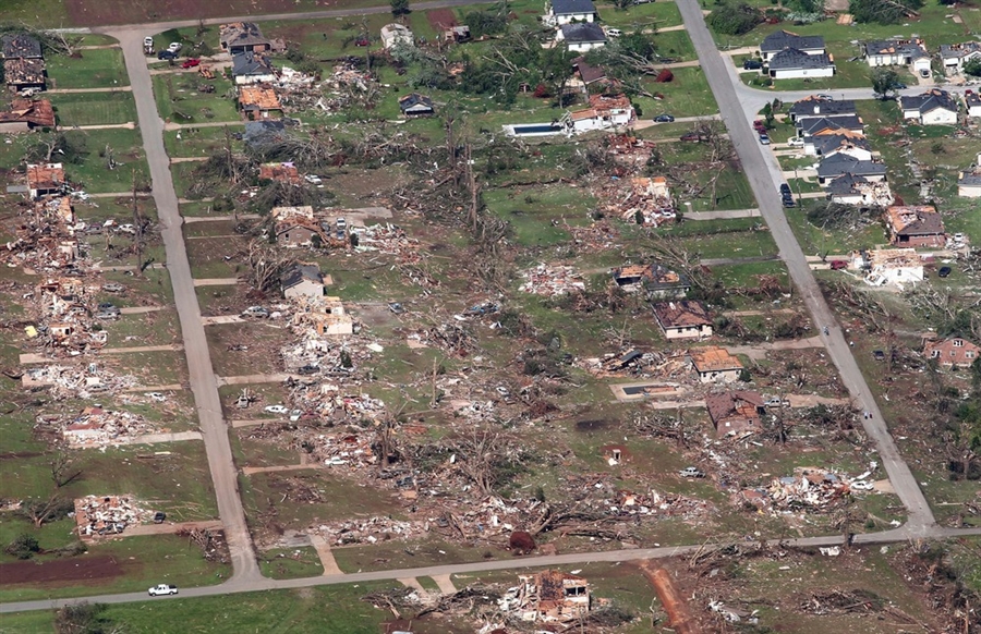
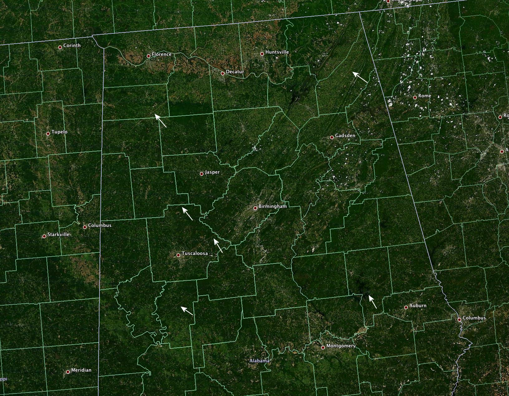
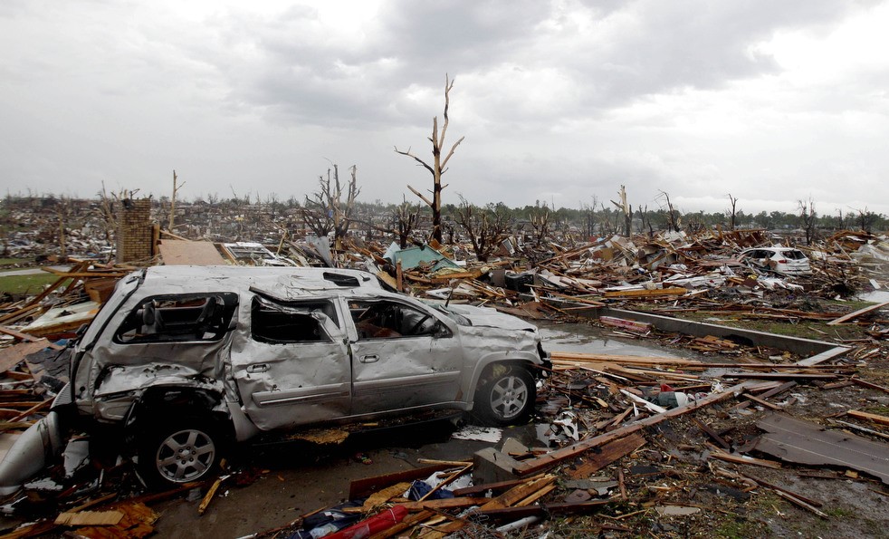
Tuscaloosa, Alabama – April 27, 2011
Tuscaloosa, Alabama isn’t a typical college town. College athletics are more than just a passion, they’re a way of life. “Roll Tide” is as much a greeting as a slogan. Everything that goes on in T-town revolves around the University of Alabama and the Crimson Tide. And, perhaps more than any other college town, there’s a strong sense of community. They are united not just by a team but by the uniquely southern attitude that your neighbors are your family. The tragedies of April 27, 2011 would bring Tuscaloosa and the entire state of Alabama together.
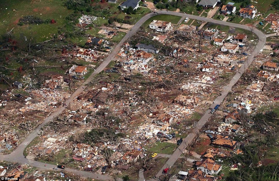
Aerial view of the devastation in Tuscaloosa.
Credit: Daily Mail (UK)
The cell that produced the Tuscaloosa tornado began in south central Mississippi, passing north of Meridian before moving into western Alabama. It quickly began to gain strength as it moved into Greene County. The tornado touched down at 4:44 pm just north of the village of Union and moved northeast, steadily intensifying. It tore through the heart of Tuscaloosa as an EF4 half a mile wide. Entire neighborhoods were devastated. Hundreds of homes were completely destroyed and hundreds more were severely damaged. In the section of town south of the university campus along University and MacFarland Boulevards along with portions of 15th Street, the destruction was nearly complete. Most buildings were destroyed or damaged beyond repair. The Rosedale, Forest Lake, and Alberta City neighborhoods were devastated. Dozens of homes were destroyed and some were swept away. The Alberta Elementary School and the Alberta Park Shopping Center were flattened.
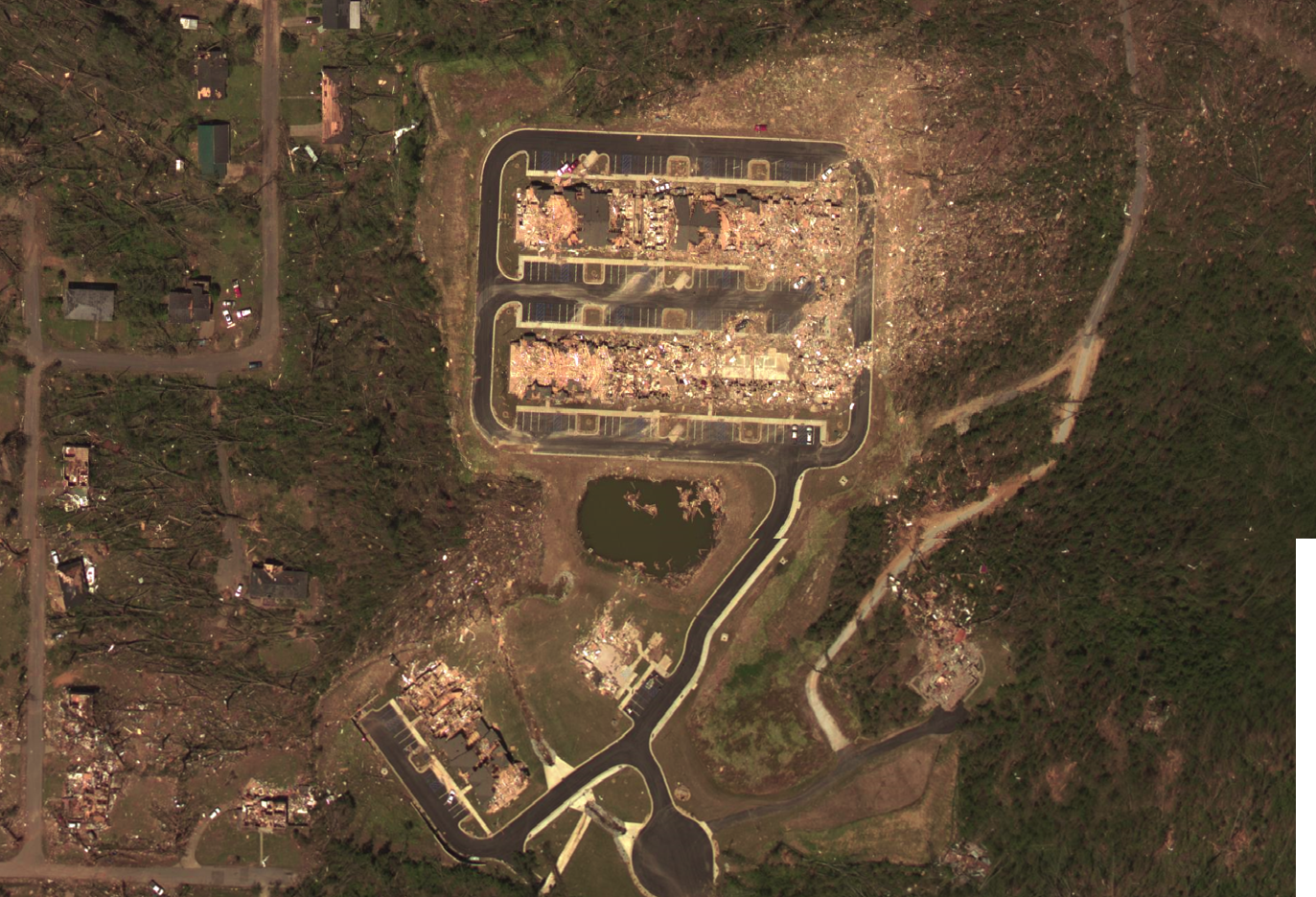
Aerial view of the extreme damage at the Chastain Manor Apartments. The southeast portion of the complex as well as the clubhouse at the bottom center of the picture have been almost entirely swept away.
Credit: NOAA
The tornado continued to intensify as it passed east of town, growing to a mile wide. Much of the Chastain Manor apartment complex was destroyed and portions of it were swept away. A wood-frame clubhouse built of brick and anchored to its foundation was also swept away. There was evidence of damage to the foundation as a portion of the concrete had buckled and cracked. A piece of the slab was reportedly missing. Nearby, a well-built two story home was completely swept away. Well-sealed manhole covers, weighing at least a hundred pounds, were pulled out of nearby streets and thrown hundreds of feet through the air. Trees were stripped and debarked in this area as well.
Aerial view of the destruction in Tuscaloosa.
Credit: NBC News
The tornado weakened some as it passed over more rural areas northeast of Tuscaloosa. It reintensified as it bore down on the town of Concord. Numerous homes on the southeast side of town were destroyed and a few poorly anchored homes were swept away. Southwest of town, a railroad trestle was destroyed and one of the 34 ton steel support structures was thrown a hundred feet up a hill. The tornado continued to intensify as it ripped through Pleasant Grove. Numerous well-constructed homes were leveled and some were completely swept away. Some large industrial warehouses of steel frame construction were completely destroyed and at least one was nearly swept away. At a coal yard northeast of Pleasant Grove, a train was derailed and a 36 ton coal car was thrown nearly four hundred feet.
A view of the devastation in Pratt City.
Credit: Daily Mail (UK)
The tornado was now national news. Television cameras captured the tornado as it bore down on the northern suburbs of Birmingham. Lighter damage was observed in McDonald Chapel, where several homes were unroofed and wrecked. The tornado then tore through Pratt City and Smithfield Estates, the same area devastated by the 1977 tornado, as a low-end EF3, destroying or wrecking numerous homes. Cars were flipped and tossed and an apartment complex lost its roof. The tornado steadily lost energy after that. It briefly ballooned to over a mile wide as it crossed I-65, causing EF2 damage in the area. It struck the south side of Fultondale before finally lifting a couple miles west of Center Point. It had traveled over eighty miles and devastated portions of two major cities.
Some of the extensive damage in the Birmingham area.
Credit: Daily Mail (UK)
The tornado killed 64 people and injured another 1500. It was only the third time in recorded history that two tornadoes killed more than sixty people in a 24-hour period (April 24, 1908 and April 5/6, 1936). The devastation was staggering. Over a thousand homes were completely destroyed or damaged beyond repair. Damage was estimated at $2.2 billion, making it the costliest tornado in history (a title it unfortunately held for less than a month). Among the dead were six University of Alabama students, including the girlfriend of Crimson Tide long snapper Carson Tinker. It was the most devastating single event in Alabama history.
Satellite image of the damage path through Tuscaloosa.
Credit: DigitalGlobe
The supercell that produced the tornado went on to be the most prolific of the outbreak. Shortly after the Tuscaloosa tornado lifted, an EF4 touched down southeast of Clay and devastated the Shoal Creek Valley area north of Ohatchee. Twenty-two people were killed. The tornado traveled nearly a hundred miles all the way into Georgia before lifting south of Rome. The same cell produced two additional tornadoes, both EF3s, over northern Georgia.
Considerable debate continues over the final rating of the tornado, particularly the damage at the Chastain Manor apartments as well as in the Pleasant Grove area. One of the three NWS survey teams rated the tornado EF5. The other two, as well as FEMA’s survey team, rated it EF4 due to questions about construction and details of the damage. For example, in the most extreme damage area at Chastain Manor, an understory of the apartment complex, which was only partially above ground, was not swept away. Meanwhile, the clubhouse, while made of brick and built to the standards of a home, had few interior walls. The controversial rating of this tornado as well as two others in Oklahoma a month later sparked significant discussion on what is and is not EF5 damage and how the Enhanced Fujita Scale is being applied.
A high resolution satellite image of the damage path through Tuscaloosa County.
Credit: NOAA
Rainsville, Alabama – April 27, 2011
The terrible outbreak continued into the evening hours. As the Tuscaloosa area was being devastated, an extremely violent tornado tore through the Bridgeport area in extreme northeastern Alabama. Several homes were destroyed and at least one was completely swept away, with all the debris carried well downstream. A concrete staircase was torn from the foundation and left on the slab and a portion of the slab was pulled up. This tornado was officially rated EF4 but may have been an EF5. In south central Mississippi, an EF4 ravaged the village of Louin, destroying several homes and killing seven people. A few poorly anchored homes were swept away.
The brick and mortar Mountain View Baptist Church in Sylvania was leveled.
Credit: NOAA
Meanwhile, as the Tuscaloosa tornado was winding down, another series of supercells were gaining strength in northeastern Alabama. At 6:19 pm, a tornado touched down in the Lakeview community in western Dekalb County and moved northeast. It intensified quickly destroying several homes east of Fyffe and Shiloh, some of which were completely swept away. The tornado then tore through the southeast side of Rainsville as an EF5 over half a mile wide. Numerous well-constructed homes were destroyed and many were completely swept away.
A chunk of the foundation at this leveled Rainsville home was pulled out of the ground by the force of the wind.
Credit: NOAA
Along Lingerfeldt and Skaggs Roads, the damage was incredible. One well-built stone house simply vanished, the debris carried up to a mile downstream. A concrete and stone supporting pillar attached to the foundation was pulled out of the ground and thrown, taking a piece of the foundation with it. Nearby, a well-anchored brick home disintegrated and some of its supporting anchors were pulled out of the ground. At another home, also wiped from the face of the earth and the debris carried away, a concrete porch was torn from its pillars, smashed to pieces, and thrown 150 yards. An 800 pound steel safe bolted into solid concrete was torn loose and thrown 600 feet, its door torn from its hinges. A pickup truck was hurled 250 yards and obliterated. A piece of the driveway was also pulled up. All of this was at the same home. The owner’s family huddled in an adjacent storm shelter as their home was destroyed. The tornado scoured several inches of topsoil from around the edge of the shelter. Next door, a mobile home was pulverized into small pieces and carried away. Several other vehicles in this area were thrown hundreds of feet.
This home in Sylvania was completely obliterated, leaving only the porch and the foundation walls.
Credit: NOAA
Homes along Crow Lane and Wells Circle were also swept away and several cars were thrown considerable distances. A section of sidewalk was pulled up in this area and significant ground scouring was observed. Continuing northeast, the tornado continued to cause extensive devastation. Numerous homes southeast of Sylvania were completely destroyed and some were swept away. At one home, a concrete porch was displaced and broken in half. Throughout the area, trees were stripped and debarked. An old church built in 1902 was destroyed and a new addition was severely damaged. The section of hallway connecting the two was swept away. Many more homes were destroyed east of Henegar and south of Ider and some poorly anchored homes were swept away. The tornado weakened as it approached the Georgia state line, lifting just across the line near the town of Rising Fawn.
Aerial view of some of the damage in Rainsville.
Credit: DeKalb County Sheriff’s Department
In all, 25 people were killed and many more were injured (just how many is unclear, the official record simply lists “0”). Hundreds of homes were severely damaged or destroyed. Many of the homes swept away were well-constructed and anchored to their foundations. Some even had additional reinforcement. The same supercell spawned another violent tornado that devastated the Ringgold, Georgia area. Numerous homes were destroyed and some were completely swept away. This tornado flirted with EF5 intensity and may have briefly reached it, which would’ve made it the first in Georgia history (despite roughly thirty F4/EF4s). Twenty people were killed.
The outbreak finally began to taper off after about 9 pm Central Time. The last of the fifteen violent tornadoes that day struck the Lake Martin area of Alabama near the town of Dadeville shortly after 8pm CT. Seven people were killed. In all, 207 tornadoes touched down in the 24-hour period from midnight April 27 to midnight April 28, breaking the 1974 Super Outbreak’s record of 147. This led to it being dubbed the “Super Outbreak of 2011” or “Super Outbreak II”, though it never reached the 1974 event’s many other impressive statistics. It was one of the most devastating tornado days in American history. 324 people were killed and damage came to over $11 billion.
A satellite view of the tornado tracks of April 27 in Alabama.
Credit: NASA
A major grassroots relief effort was begun throughout the south and Alabama received several offers of international aid. Notably, a large group of Auburn fans, the Crimson Tide’s arch rival, organized numerous relief shipments for the people of Tuscaloosa as well as other stricken areas, taking donations from throughout the country. They later formed a non-profit, disaster relief organization called Toomer’s For Tuscaloosa. The scars of April 27 can still be seen in Alabama and other parts of the south, but little by little, normalcy has returned. Towns have been rebuilt and the people have recovered by relying on their faith and each other.
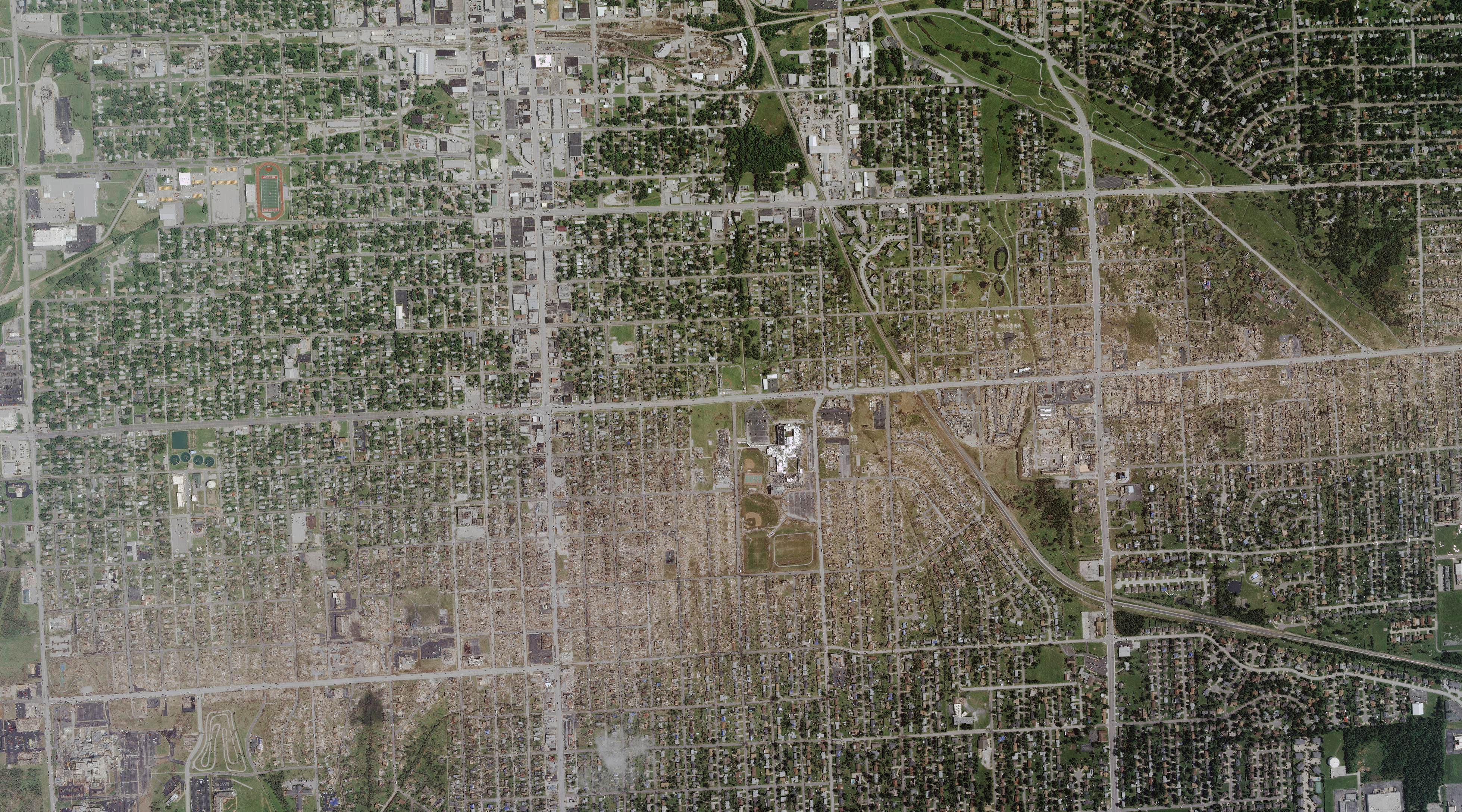
Joplin, Missouri – May 22, 2011
Meteorology is a very humbling field. Every day, it forces you to confront the fact that there are things in this world that are simply out of your control. Nature is so incredibly powerful that it defies human comprehension. In an instant, entire landscapes can be irrevocably altered. Modern technology has allowed us a glimpse into how these events happen and how to see them coming. However, meteorologists can only try their best to predict them and understand them; they cannot stop them. And for all of the technological achievements of the modern world, we are all but human beings.
Entire subdivisions were simply annihilated.
Credit: Jeff Roberson/AP
It was a hot, humid day in Joplin, Missouri, a mid-sized city of about 50,000 people in the southwestern part of the state near the Kansas and Oklahoma state lines. A strong upper level trough and associated cold front were moving through the Great Plains. A stream of low level moisture was moving up from the Gulf of Mexico into a local wind shear maximum in eastern Oklahoma, northwestern Arkansas and southwestern Missouri. Supercell thunderstorms began to develop at around 4:45 pm. Shortly after 5pm, a supercell began to explosively intensify over extreme southeastern Kansas as it headed for the Missouri state line. What happened next was sudden, appalling devastation.
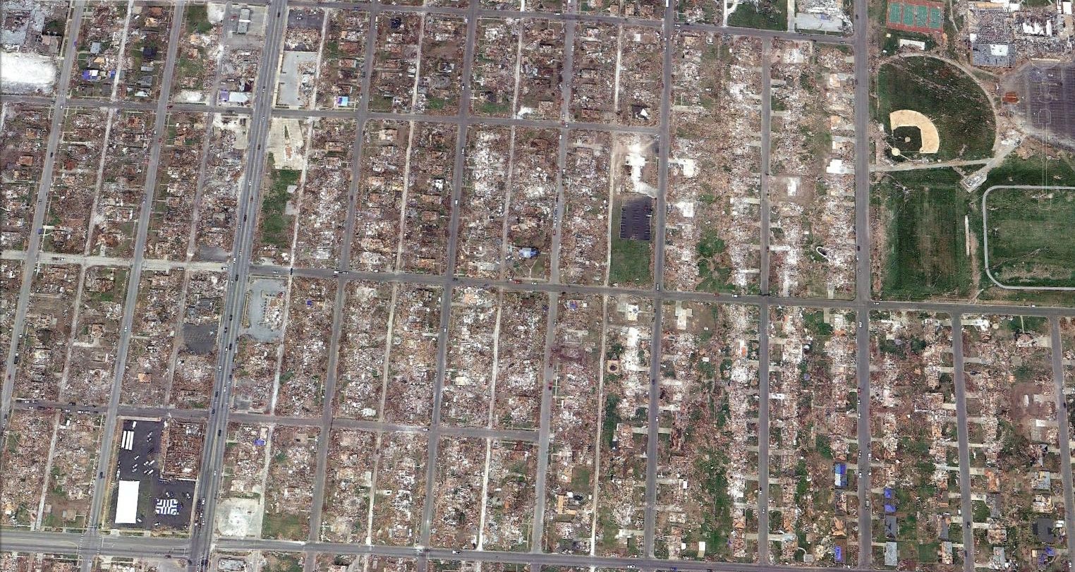
A satellite image of the incredible devastation. In the section between Grand and Iowa Avenues in the upper right of the picture near the athletic fields, multiple swept away homes can be seen.
Credit: Google Earth
A tornado touched down near the intersection of 32nd Street and the JJ Highway along the Jasper-Newton County line, and moved just north of due east. It exploded into a monstrous mile-wide EF5 within minutes as it tore through the south side of Joplin. An entire section of the city was simply gone. Whole neighborhoods vanished. At some homes, concrete porches were torn loose and carried away. Portions of foundation slabs were scoured from the ground. The entire section around 26th Street and McClelland Boulevard was wiped out. Virtually every building was flattened and many were completely swept away. The Greenbriar nursing home was leveled and partially swept away. 21 people died there. Joplin High School and a three story apartment complex were also destroyed. Numerous examples of extreme phenomena occurred. One hundred pound manhole covers were sucked out of the roads and carried away and a large piece of wooden debris was speared into a concrete curb. A rubber hose was impaled in a tree. Pieces of cardboard and an intact wooden chair were found imbedded in the side of a stucco house. In many areas, twigs and other lightweight debris were found speared into trees or houses.
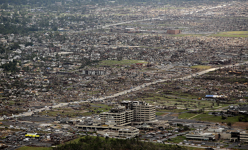
An aerial view of the devastation around St. John’s Regional Medical Center. The hospital was so badly damaged it had to be condemned.
Credit: Charlie Riedel/AP
The tornado slammed directly into St. John’s Regional Medical Center, a sprawling hospital complex in the southwestern portion of the city. It was as if a bomb went off. Doctors and nurses were thrown to the floor as a cloud of dust and glass ripped through the building. The hospital’s concrete, steel-reinforced exterior walls buckled and cracked. A hospital visitor was killed and five patients on life support died when all power systems failed. The entire building was reportedly displaced from its foundation by four inches. The hospital was so badly damaged that it had to be condemned and torn down.
The pictures speak for themselves.
Credit: AP
An adjacent medical art building was leveled and steel beams were twisted and crumpled. A large concrete, steel-reinforced staircase was uplifted several inches and cracked. Steel frame roofing was found wrapped around trees. Cars in the parking lot were picked up and thrown hundreds of yards. Some were never found. Concrete parking stops weighing over 300 pounds and anchored with rebar were torn loose and thrown over fifty yards. A helicopter sitting on the hospital’s rooftop helipad was carried 250 yards. A semi-truck was thrown roughly a quarter of a mile, stripped to the steel frame and wrapped around a debarked tree.
The Home Depot warehouse, where steel beams were mangled and twisted.
Credit: Tom Uhlenbrock/UPI
Numerous large commercial buildings suffered extreme damage. On the southeast side of town, a Walmart “supercenter” and a Home Depot were both completely destroyed. At the Walmart, asphalt was scoured from the parking lot and at the Home Depot, steel support beams were crumpled and twisted. Some were torn loose and found badly mangled or even broken in two in a nearby field. At both places, large vehicles, including semi-trucks, were thrown hundreds of yards. Others were piled on top of one another. Nearby, several large industrial warehouses of steel-frame construction were almost completely swept away. Steel beams were twisted and some were snapped off at the base. Anchor bolts were torn out of the foundation. Heavy commercial vehicles were thrown up to 400 yards. Multiple homes in the area were also swept away.
This warehouse was completely leveled and steel beams were twisted or snapped off at the base.
Credit: NOAA
The tornado began to steadily weaken as it moved out of the city and curved to the southeast. A shadow of its former self, the tornado finally lifted a few miles east of Diamond. The cataclysm it left behind defies comprehension. 158 people died. It was the deadliest US tornado in 64 years. Three others died of indirect causes, including a police officer who was struck by lightning while assisting with rescue efforts. Roughly 1,150 were injured. Nearly a quarter of the city was wiped out. According to the National Weather Service report, nearly 7,000 homes were destroyed or damaged beyond repair. Hundreds of businesses and numerous public buildings were also destroyed. St. John’s Hospital is believed to be the largest structure ever damaged beyond repair by a tornado. An estimated 15,000 vehicles were destroyed and many of them were thrown hundreds of yards. Dozens were never found.
Sunset over the ruins of Joplin.
Credit: AP
The tornado took Joplin largely by surprise. National Weather Service issued its first tornado warning on the cell at 5:17pm, seventeen minutes before the tornado touched down. However the projected path of the storm was severely miscalculated and only the north side of Joplin was in the warning. The error was corrected with the 5:24 update just ten minutes before the tornado began. Tornado sirens did not sound in Joplin until a few minutes before the tornado struck the city. There was also a second siren that many confused for an “all clear”. The tornado was also wrapped in rain and poorly visible. In addition, many people did not have access to basements or underground storm shelters. There was little they could’ve done. Many of the people who were killed were in their best available place of shelter. Some died in basements. A store manager was sucked out of a walk-in freezer.
Joplin tragically highlighted the limitations of the modern warning system. The success of warnings hinges on their accuracy, timeliness, public response to the warnings, and situational context. The accuracy and timeliness are things meteorologists can control, however people must understand what they’re being told, know what to do, and have a safe place to go. And in tornadoes as strong as Joplin, the only place where survival can be guaranteed is underground. In many tornado-prone areas, most people do not have access to underground shelters. The bottom line is, warnings only take you so far. Sometimes meteorologists are wrong, sometimes people don’t listen, and sometimes your safe place just isn’t safe enough. Sometimes nature wins. On May 22, 2011, nature won.
This spectacular satellite image shows the incredible devastation wrought by the tornado on Joplin.
Credit: GeoEye
El Reno, Oklahoma – May 24, 2011
One of several homes that were swept away in the El Reno area.
Credit: NOAA
Just two days after Joplin, another major outbreak struck central Oklahoma. The low pressure system responsible for fostering the conditions that led to the Joplin tornado slowed to a crawl and the frontal boundary became stationary. On the 24th, a shortwave trough moved in and caused a significant increase in wind shear. With warm, moist air streaming in from the Gulf of Mexico, the atmosphere proved explosive. Beginning around 3pm, supercell thunderstorms began to roll through central Oklahoma. One of the cells became particularly vigorous. At 3:30pm it spawned an EF3 tornado near the town of Lookeba. Shortly after that one lifted twenty minutes later, another formed a few miles southeast of Hinton. This one would grow into a monster.
The foundation of this storage garage was broken into pieces.
Credit: NOAA
It moved northeast across rural Canadian County, steadily intensifying. By the time it reached Interstate 40 a couple miles east of El Reno, it was a monstrous EF5 over a mile wide. Cars were picked up off the road and thrown hundreds of yards, resulting in three deaths. One was stripped to the frame, mangled and twisted, and found resting against a completely debarked tree. A 20,000 pound tanker truck was thrown a full mile. It was in this area that a mobile Doppler radar unit measured winds of 210 mph inside the funnel. A nearby mesonet automated weather station recorded a 151 mph gust as the tornado passed by. North of El Reno, the devastation was incredible. Several well-built homes were wiped out of existence, the debris carried away. An oil derrick weighing 950 tons was pulled out of the ground and rolled four times. Some of the thick, steel support struts bolted to the structure were torn loose and carried away. A storage garage vanished and its foundation was severely cracked. Numerous vehicles were thrown hundreds of yards. One was found wrapped around a debarked tree. Intense ground scouring was observed, with much of the tornado track reduced to deep tracts of mud.
This SUV was thrown 750 yards, nearly half a mile, and obliterated.
Credit: Jim LaDue/NWS
The tornado raked by the town of Piedmont as an EF4, destroying numerous homes and seriously damaging many others. The Falcon Lake neighborhood northwest of Piedmont near the Kingfisher County line was devastated. Two children were killed there. Moving into Logan County, two people caught out in the open were killed by the tornado. Several mobile homes were destroyed and trees were debarked. EF3 damage was observed just outside of Guthrie as a few homes were wrecked. The tornado somewhat miraculously missed the town center, passing just to the west and north. It weakened quickly thereafter, lifting just northeast of Guthrie. It had travelled 63 miles.
This car was wedged in a tree and speared with a wooden missile by the force of the wind.
Credit: unknown
In all, the tornado killed nine people and injured 181. Numerous homes were leveled and some were completely swept away. It was Oklahoma’s first F5/EF5 tornado in twelve years. As the El Reno tornado was winding down, a pair of extremely violent tornadoes moved through Grady and McClain Counties, causing extensive devastation near the towns of Blanchard and Dibble. Well-built homes were completely swept away, vehicles were thrown great distances, and extensive ground scouring was observed. Both of these tornadoes were officially rated EF4 but are widely believed to have been EF5s.
Blanchard, Oklahoma – May 24, 2011

Credit: Heather Moser
In today’s modern world, science has been blessed with a veritable cornucopia of data. Every second of a major tornado’s life can be tracked and cataloged. This wealth of information can be a gift and a curse. The Fujita Scale as originally conceived was a damage scale to rate the severity of tornadoes based on the extremity of the damage, with estimates of the approximate wind speed range that would do that kind of damage. Now, surveyors seek to use damage to accurately estimate the wind speed in the tornado, which is very difficult to achieve. First off, winds in a tornado are intensely rotating, which means mathematically slower wind speeds are going to do a LOT more damage. Also structures vary greatly in construction quality across the country and if you’re trying to rate tornadoes in the middle of the empty Great Plains, you’re out of luck. And modern science has allowed us to analyze every last detail of destroyed homes, searching for weaknesses that might allow it to fall victim to a marginally weaker tornado. As a result, many outside scientists and researchers have argued, we’re now holding tornadic destruction to a much higher standard than Dr. Fujita ever intended.
One of many swept away homes in the Blanchard area.
Credit: NOAA
While the El Reno tornado was tearing through the northern outskirts of Oklahoma City, another tornado touched down at the southern edge of Chickasha and moved northeast. There the tornado wrecked a mobile home park and an apartment complex. The tornado then moved out over the open plains parallel to I-44 and began to intensify. Shortly after crossing Friend Road, the half-mile wide EF4 began to level rural homes. An SUV was thrown 300 yards and crumpled into a ball. Further to the northeast, more well-built homes were flattened and several vehicles were thrown hundreds of yards. A large, industrial oil pump was toppled over. Grass and topsoil were torn up throughout the path and trees were shredded and debarked.
Several well anchored homes simply vanished.
Credit: NOAA
The tornado briefly weakened as it passed northeast of Middleburg but reintensified as it bore down on the edge of Blanchard. Cars parked along Morgan Avenue were thrown 400 yards and stripped to the frame rails. Some were found wrapped around trees. Asphalt was torn from nearby Kitty Hawk Road. The tornado actually narrowed as it intensified, crossing into McClain County as a high-end EF4 a quarter of a mile wide. It ripped through rural subdivisions on the north side of Blanchard, wiping out numerous well-built homes, some of which completely vanished. A pickup truck was thrown 600 yards, a third of a mile, and smashed to pieces. A steel-reinforced concrete “dome” house built to withstand tornadoes took a direct hit, sustaining extensive damage from flying debris and it’s frame was partially cracked.
Curving more to the north, the tornado began to weaken as it passed east of Newcastle as an EF3. In this area, several cars were sucked out from underneath a highway overpass and tossed down the road. The tornado continued to narrow and weaken before finally lifting just west of Moore. Luckily, just one person was killed, no doubt due to advance warning, and 48 were injured. This tornado was controversially rated EF4 because some of the anchor bolts on swept away homes (whose spacing was half of the minimum required by Oklahoma building codes) were missing washers and inconsistent scouring patterns however it is widely believed to have been an EF5.
Dibble, Oklahoma – May 24, 2011
Numerous well anchored homes vanished.
Credit: NOAA
While the Blanchard tornado was leaving its path of destruction, another controversial tornado touched down just northwest of Bradley and moved northeast, steadily intensifying. It crossed into rural McClain County as an EF3. By the time it crossed Highway 76, it was at least a strong EF4 half a mile wide. Well-built homes along the highway were swept away, the debris carried hundreds of yards downstream. Vehicles were thrown great distances and destroyed beyond recognition. More homes were swept away south and east of Dibble, one of which had nearly twice as many anchor bolts as required. However a fence around that house’s yard was still standing, proving just how fickle tornadoes can be.
The devastation continued as the tornado passed northwest of Washington, where more homes were leveled. The tornado was narrower in this area but still incredibly intense. Arguably the most extreme damage of all occurred near the end of the tornado’s life southwest of Goldsby. A large, well-anchored home specifically built to be tornado resistant simply vanished and large metal storage tanks bolted into solid concrete were torn loose and thrown into an adjacent field. The survey team only rated the damage EF4 because a few of the anchor bolts were missing washers. This damage in particular is widely suspected to have been EF5. The NWS office in Norman even admitted that this tornado as well as the one in Blanchard were “plausably EF5”. Debris from the tornado fell on Norman several miles to the north. Passing just west of Goldsby, the tornado caused minor damage to David Jay Perry Airport before lifting.
Luckily, no one was killed in this tornado, another win for the tornado warning system. 61 were injured. Much like the Dunlap and Strongsville tornadoes during the Palm Sunday Outbreak in 1965, the rating of the Blanchard and Dibble tornadoes have caused considerable controversy and sparked significant debate over how the Enhanced Fujita Scale is being applied.
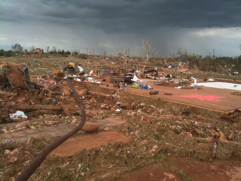
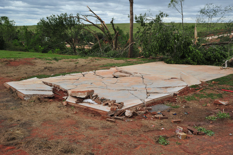
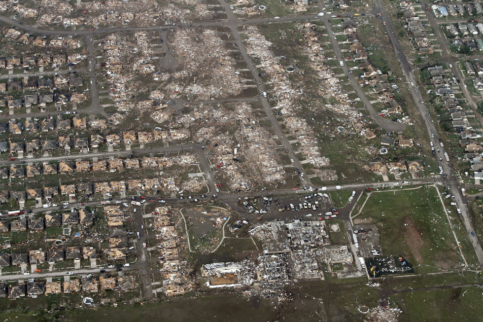
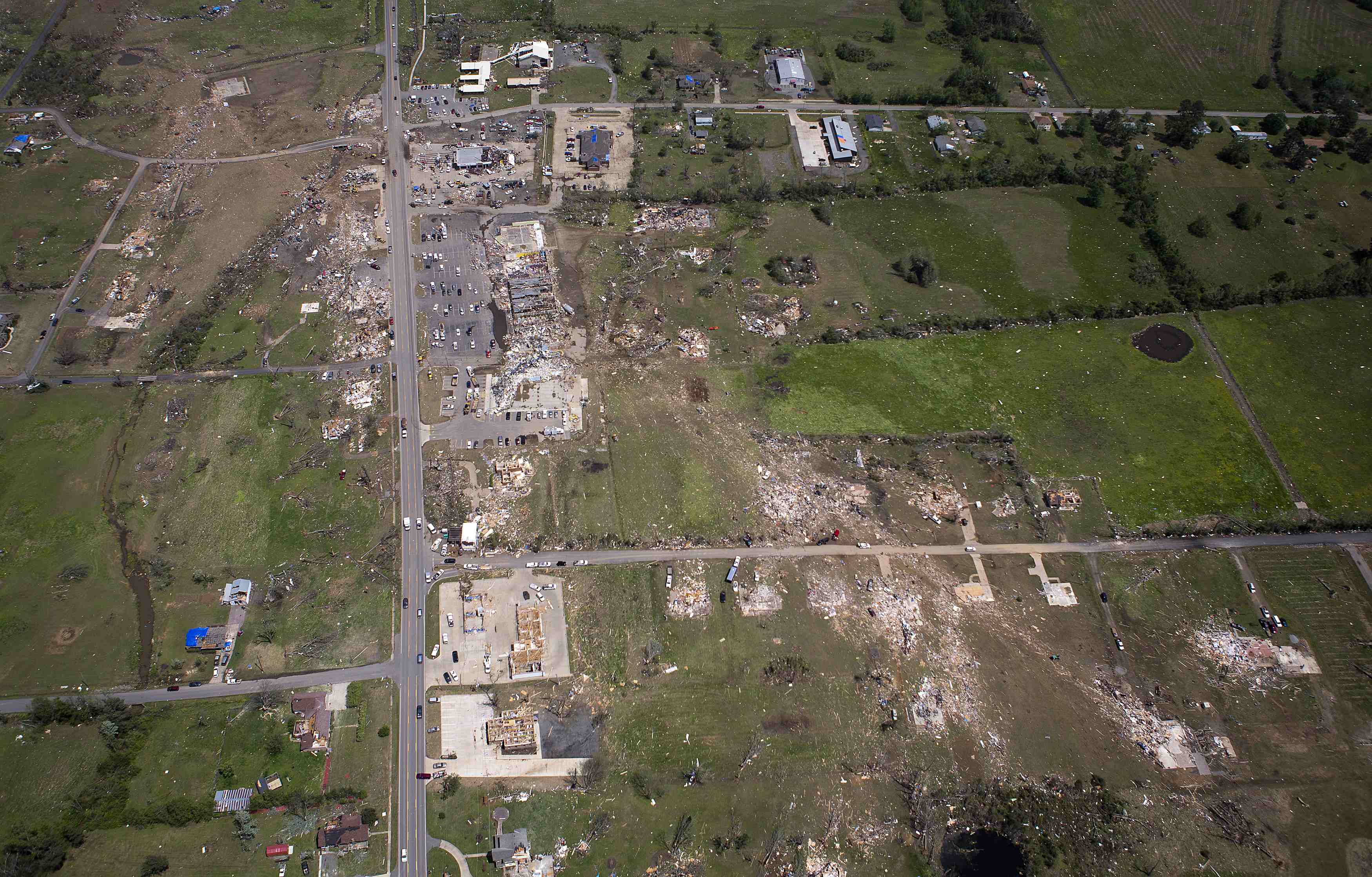
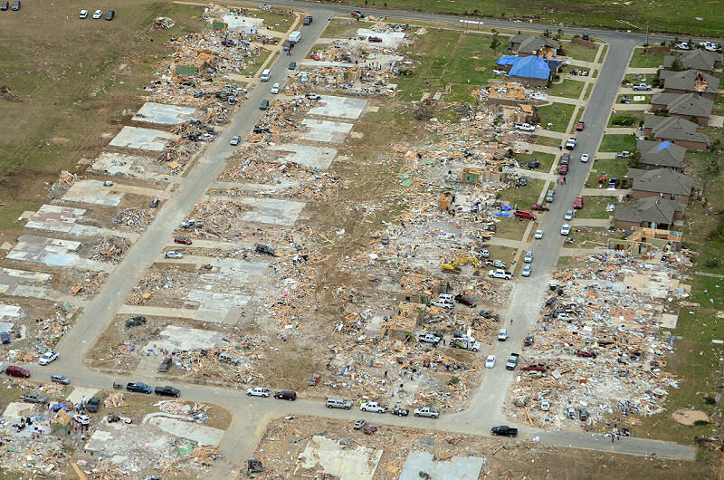
Moore, Oklahoma – May 20, 2013

Aerial view of the devastation in Moore.
Credit: FEMA
In the fourteen years since the terrible 1999 tornado, life had returned to normal in Moore, Oklahoma. Neighborhoods had been rebuilt and parks restored. Life had moved on. All that remained of the devastation of ’99 were memories. While much had changed in Moore, much remained the same. More storm shelters were built, but many couldn’t or elected not to spend the money. Tornadoes were so common that people became desensitized to them. They just assumed that when the time came, they’d know what to do. The belief was that the 1999 storm was a once in a generation event. And as I’ve pointed out before, when a tornado gets that strong, there’s only so much you can do.
It was a warm and very humid day in the southern Great Plains. A deep trough was digging south through the Dakotas into the upper Midwest. This system had been generating a prolonged outbreak over the past two days. The night before, an EF4 devastated rural neighborhoods just outside of Shawnee near the village of Dale. Fortunately just two people were killed. As the OKC area was still reeling from the tornados of the 19th, the very next afternoon, Moore would again be the scene of appalling devastation.
A view of the devastation around Briarwood Elementary School.
Credit: Steve Gooch/AP
It was the afternoon’s very first tornado. It touched down a couple miles north-northwest of Newcastle and moved just north of due east. It intensified very quickly, reaching EF3 strength within minutes. Soon it was a mile-wide EF4 as it bore down on Moore. It continued to intensify as it slammed into the neighborhood of Westmoor. Rows of homes were wiped out and some were completely swept away. A ten-ton water tank was ripped from its anchors and thrown half a mile. The real tragedy was yet to come, however, as local schools were still in session.
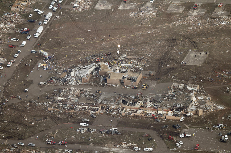
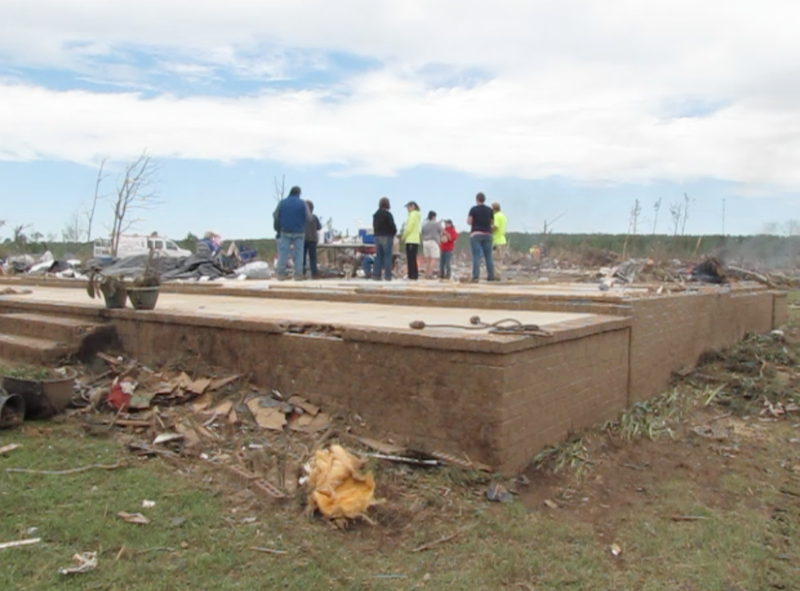
Plaza Towers Elementary after the tornado. Note the entire row of swept away homes behind it. A wider view from Google Earth can be seen here.
Credit: Steve Gooch/AP
The tornado slammed into Briarwood Elementary School. The entire structure, build of concrete and steel, was leveled as terrified teachers and students huddled in hallways and bathrooms. Miraculously, everyone at the school survived. Sadly, this miracle was not repeated at nearby Plaza Towers Elementary. The large brick structure was completely flattened. Dozens of children and teachers were trapped inside. A broken water main flooded an interior room where several people were taking shelter. Seven children drowned. Fortunately, however, everyone else at the school that day was pulled from the wreckage alive. Nearby subdivisions were devastated. Scores of homes were destroyed and some were completely swept away. An entire row of homes behind Plaza Towers vanished.
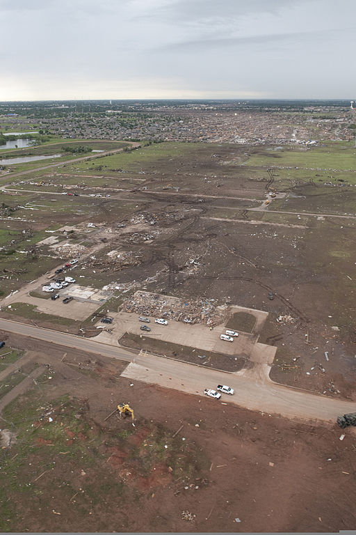
Aerial view of some of the extreme damage in Moore.
Credit: Oklahoma National Guard
The devastation continued as the tornado ripped through the heart of Moore. A bowling alley and a 7-Eleven were completely flattened. Four people in the 7-Eleven were killed, including a small child. Numerous cars were thrown great distances. Several vehicles were piled up at the entrance to the Moore Medical Center, which suffered heavy damage. Entire subdivisions near Plaza Towers and the Medical Center were almost entirely destroyed. As the tornado crossed Interstate 35, cars were flung from the road into nearby fields or scattered around the median. It then moved into the east side of Moore where complete destruction of homes continued. It passed just south of Moore High School, causing heavy damage to Highland East Junior High. The tornado began to gradually narrow and weaken thereafter, lifting in the Windy Hill area west of Stanley Draper Lake.
The devastation was almost a carbon copy of the 1999 event. Hundreds of homes were destroyed and several were completely swept away. Twenty-four people were killed, including nine children, and 377 were injured. Initial reports had the death toll in the nineties before being corrected. Damage came to roughly $2 billion. It was the country’s fourth billion-dollar tornado in two years.
El Reno, Oklahoma – May 31, 2013
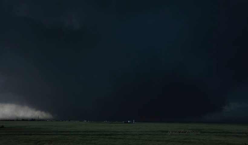
A view of the massive tornado moving over open country south of El Reno.
Credit: Gene Moore
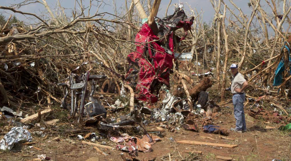
Tornado chasing has always been inherently dangerous. However, before May 31, 2013, it had, perhaps remarkably, never claimed anyone’s life. The popularity of storm chasing exploded in the 1990s and 2000s, particularly following the release of the movie Twister in 1996. Numerous amateur thrill seekers along with many scientists, students and members of the media, chase in the Great Plains every May. Recently, academic chasers have gotten used to “chaser jams,” caused by the large number of amateur chasers crowding the roads. In recent years, these chasers have begun to take bigger and bigger risks, getting much closer to tornadoes than ever before. An increasing number of them have been chasing on the northeast side of the tornado, referred to by meteorologists as the “bear’s cage.” Chasing in the bear’s cage typically provides the best view of the funnel and is the best place to put scientific instruments. However it is an extremely dangerous place to be. The tornado can easily change direction and head right for you, leaving you with no place to go. It could be argued that, sooner or later, tragedy was inevitable.
It had been just eleven days since Moore and another outbreak seemed imminent. Just like the outbreak two weeks earlier, a slow-moving low pressure system and associated cold front were producing a prolonged series of tornado outbreaks across the Great Plains. Conditions maximized on May 31, with CAPE values (see Plainfield section for an explanation of CAPE) soaring to over 4000 J/kg as warm, moist, unstable air streamed in from the Gulf of Mexico. A dryline was moving into central Oklahoma ahead of the cold front. Now, two years after the 2011 tornado, the area around El Reno would be visited by a monster unlike anything ever seen before.
This brick home was destroyed by the tornado. The damage was rated EF3.
Credit: NOAA
At around 5:30 pm, a series of supercells began exploding over west central Oklahoma. At 6:03 pm, a tornado touched down eight miles southwest of El Reno and moved southeast over open country. Chasers crowded Interstate 40 and rural roads to the northeast, hoping to catch a glimpse of the tornado or, in the case of Tim Samaras and his Twistex team, gather valuable scientific data. Tim Samaras was a scientist. He dedicated his life to advancing our knowledge of tornadoes. In 2003, his instruments recorded a world record pressure drop of 100 millibars inside the Manchester, South Dakota F4. The 850 millibar reading was the lowest surface pressure ever recorded on Earth. Safety was always his top priority and he was widely viewed as the safest chaser out there.
A view of the tornado as it neared peak strength.
Credit: Nick Nolte
Meanwhile, the tornado was turning into a monster. As it passed south of El Reno, it was a mile and a half wide and still growing. All chaos was breaking loose in the Oklahoma City metro. In the wake of the Moore tornado, the largely well-founded belief that it was impossible to survive a tornado that strong without an underground storm shelter or safe room was perpetuated. As news of the immense size of the El Reno tornado was broadcast over local news stations, people began to panic. Compounding the issue, KFOR chief meteorologist Mike Morgan told people on air that if they couldn’t get underground to get in their cars and flee, something strongly discouraged by the National Weather Service. Interstates already crowded with rush hour traffic became parking lots.

The SUV of Mike Bettes’ Tornado Hunt chase team after it was thrown 200 yards by the tornado. Everyone inside miraculously survived. Others weren’t so lucky.
Credit: NBC News
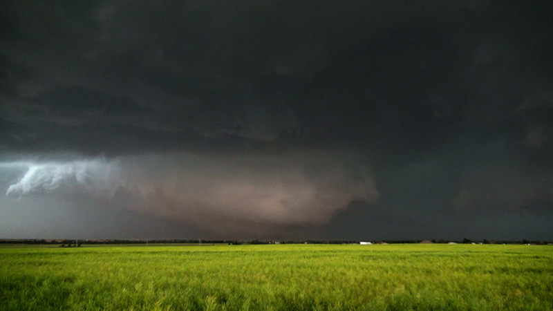
The tornado continued to explode in size and intensity as it began to take a hard left turn, headed right for the chasers along and south of I-40 east of El Reno. At its peak about three miles southeast of El Reno, it was an incredible 2.6 miles wide, making it the largest tornado ever recorded. Large tornadoes are known to generate satellite vortices called suction vortices. Suction vortices can be extremely powerful and very little is known about them. They swirl erratically around the periphery of the tornado at speeds of over 100 mph. Their movements are impossible to predict and exponentially increase the danger of being anywhere near the tornado. And with the main tornado being so large turning hard left into the bear’s cage without warning, it was a worst case scenario.
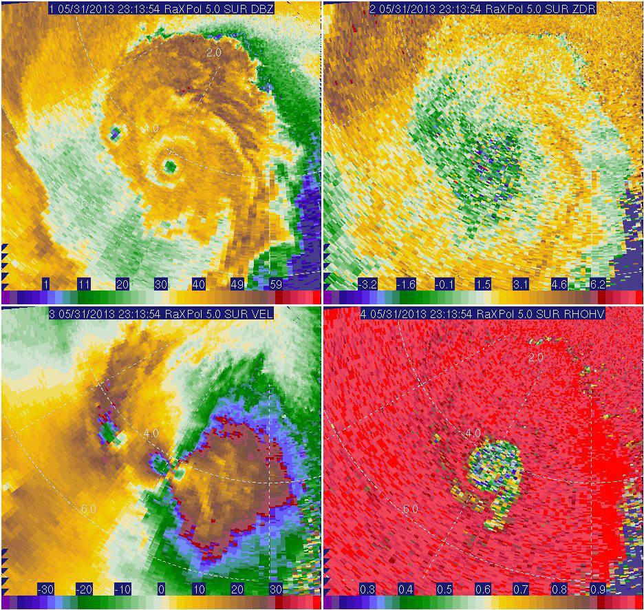
An image from the University of Oklahoma’s RaXPol Doppler Radar from when the storm was near its peak. Data from this radar was used to determine the tornado’s intensity.
Credit: University of Oklahoma
At around 6:20 pm, an advanced mobile radar unit operated by the University of Oklahoma called the Rapid-scan X-band Polarimetric (RaXPol) Doppler radar measured surface winds of 295 mph inside one of the suction vortices, 7 mph short of the first Moore tornado’s record. Winds in the main funnel were estimated at 185 mph, EF4 intensity. Meanwhile, chasers and motorists along and south of I-40 were taken completely by surprise by the tornado’s sudden turn and went racing for safety. Many of them didn’t make it. On a rural road south of I-40, the tornado, possibly one of the suction vortices, picked up Tim Samaras’ SUV and threw it hundreds of yards through the air, landing in an adjacent field. Tim, his son Paul, and close friend and fellow scientist Carl Young were killed instantly.
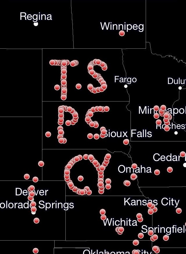
A tribute made by chasers aligning their GPS transponders to spell out the initials of Tim Samaras and his team.
Credit: RadarScope
The tornado then struck I-40. Numerous cars were thrown from the road and carried great distances. Several people were killed. The SUV of the Weather Channel’s Tornado Hunt chase team, led by Mike Bettes, was thrown 200 yards through the air. Miraculously, everyone inside survived. The driver was hospitalized with a fractured vertebrae. Everyone else, including Bettes, walked away from the wreck. Nearby, an amateur chaser along with multiple motorists, were killed. The hood of professional chaser Reed Timmer’s specially-built, tank-like chase vehicle was ripped off by the tornado. Several chasers, including KFOR’s chase team, were hit by flying debris.
The tornado turned hard right and followed along I-40 briefly before weakening and lifting back into the clouds. In all, eight people were killed, all of them in vehicles along and south of I-40. Another 115 were injured. A rural home, along with the El Reno campus of the Canadian Valley Technology Center and numerous farm buildings, were destroyed. The damage was rated no higher than EF3. The tornado reached its peak over barren farmland devoid of structures. The final rating was based on OU’s RaXPol data.
A satellite image showing the ground scar of the El Reno tornado.
Credit: NASA
Local media outlets, particularly Morgan and KFOR, were harshly criticized by meteorologists for their coverage of the tornado, particularly their recommendation that people get in their cars and flee at the height of evening rush hour. Hundreds, if not thousands, of cars jammed the highways and interstates around the OKC metro for hours. Some motorists were seen driving southbound in the northbound lanes of Interstate 35. Had the tornado hit the OKC metro, the loss of life could’ve been catastrophic. In the wake of the May tornadoes in Oklahoma, interest in storm shelters and safe rooms greatly increased. Local politicians are trying to make community shelters mandatory in central Oklahoma. These two tornadoes and the response to them will be the subject of considerable study for years to come.
Vilonia, Arkansas – April 27, 2014

Taken as the tornado entered Vilonia.
Credit: Barbara Mullins/NWS Little Rock
Three years to the day after the Super Outbreak of 2011, and 85 years after Arkansas’ only known F5 tornado, another monster hit the state. Two days before the devastation in 2011, an EF2 tornado hit Vilonia, a small town of 3,800 people about 18 miles north of Little Rock, causing widespread damage. Today was going to be a day of déjà vu’s.
Earlier that day, a closed low pressure system formed within a rapidly deepening trough that was digging across the central US. The strengthening storm system sucked a steady stream of moisture north from the Gulf of Mexico into the Great Plains and Mississippi River Valley. Tornadoes began touching down around 5pm but it wasn’t until after sundown that things really started to heat up. At 7:06pm, a small tornado touched down over rural Pulaski County six miles east of Paron and moved northeast. Within minutes, it exploded into an EF4 and a few homes in a small rural neighborhood were destroyed, one of which was swept away. Luckily, the tornado was weaker when it struck the village of Northpoint, where several homes were wrecked. It crossed Lake Maumelle and the Arkansas River midway between Roland and Natural Steps and reintensified.
Aerial view of the devastation in the heart of Vilonia. Multiple swept away homes can be seen along Cemetery Street in the foreground.
Credit: Reuters
The tornado ripped through the south side of Mayflower as an EF4. The River Plantation neighborhood was devastated. Numerous well-built homes were leveled and some were completely swept away. A woman was killed there after being sucked out of a storm shelter. The tornado then crossed Interstate 40, throwing cars and semi-trucks from the highway. An RV dealership along the interstate was leveled and RVs were hurled through the air. Three of them were found wrapped around a billboard and obliterated. The tornado weakened a bit as it roared over Lake Conway and into rural areas southeast of Saltillo. Several homes along the lakeshore were destroyed and the debris blown into the lake.
The appalling aftermath of the tornado in the Parkwood Meadows subdivision on the northeast side of Vilonia. Aspen Creek Drive, on the left, was wiped out of existence. These homes were large but supposedly anchored with nails instead of bolts, leading the NWS to conservatively rate this damage EF4.
Credit: NWS Little Rock
The weakening trend was short lived and by the time the tornado crossed US Highway 64, it was again at least an EF4. Several poorly anchored homes along the highway were swept away and cars were thrown hundreds of yards through the air. The tornado continued to intensify and was now three quarters of a mile wide. It tore through the heart of Vilonia just minutes later. The town was decimated. Hundreds of homes and businesses were leveled and some were swept clean from their foundations, particularly along Cemetery Street. Large, well-built commercial buildings were flattened. Vehicles were thrown hundreds of yards and destroyed beyond recognition. Some were never found. Others were stripped to the frame rails and wrapped around trees or found crumpled into a ball as if they were wads of paper. A 30,000 pound fertilizer tank was thrown three quarters of a mile. On the northeast side of town, the Parkwood Meadows subdivision was wiped out. An entire row of homes along Aspen Creek Drive simply vanished leaving just bare foundations. These were large, well-built suburban homes that effectively disintegrated. Half of adjacent Clover Ridge Drive was also leveled. Nine people were killed in Vilonia and over two hundred homes were destroyed.
This well-anchored home along E Wicker Street was completely swept away. The Sellers family that lived here miraculously survived in a nearby storm shelter. It’s this damage that’s believed to have been “plausibly EF5.”
Credit: Arkansas Democrat-Gazette
After leaving Vilonia, the tornado gradually began to weaken. It struck the Williams Lake area as an EF3 before moving out over more rural areas. It passed just northwest of El Paso in White County before lifting over a wooded area just northeast of that town. In all, the tornado killed 16 people, having left a 41 mile path of destruction across central Arkansas. It has become one of several tornadoes in recent years to test the limits of what is and is not EF5 damage. Many homes in Vilonia were swept clean from their foundations, but most of them were anchored to their foundations with nails instead of bolts, making them weaker and more vulnerable to tornadoes. However, the initial survey team missed a well-anchored home that was vaporized along E Wicker Street. Scouring around the foundation slab was relatively light, so the National Weather Service elected not to upgrade the tornado’s rating, but admitted that the tornado was “plausibly EF5” and that the final rating was “lower bound.”
The slew of close calls over the past decade have continued to stir controversy over the strictness of these ratings and how the Enhanced Fujita Scale is currently being applied. Adding fuel to the fire was the bombshell report by the American Society for Civil Engineering on the Joplin tornado that effectively argued that by current standards, a true EF5 rating is all but impossible because 90% of modern structures aren’t built well enough to withstand winds even approaching the 200mph EF5 threshold. And this debate will likely continue to simmer for years to come.
Possible F5/EF5 tornadoes
If this article is any indication, rating tornadoes isn’t perfect. Part of the joy in having your own website is that you get to make your own judgements. All the official F5/EF5s are here. I’ve also included other events for which I felt there was strong enough evidence to support them being F5s. I’m sure people won’t necessarily agree with all of my choices, but they were mine to make. My standard was that there had to be at least one noted expert in the field supporting the upgrade. There are several other tornadoes that may warrant an upgrade in the future. I saved them in my notes and thought I would share them with you. You will see many mentions of former meteorologist Thomas Grazulis. His detailed research into all significant tornado events dating back to the late 1800s has been invaluable in piecing together the history behind these events.
Pre-1950
-
- Salix, Iowa – June 11, 1899 – A “fine new residence” vanished on a farm near Salix. Listed as an F5 in a climatology paper published by the National Climatic Data Center (NCDC), a research arm of NOAA. Grazulis rates this tornado F4. It formed across the Missouri River near Homer, Nebraska and moved east-southeast. Farms were obliterated in both states. The devastating New Richmond F5 struck Wisconsin the following day.
- Locust Grove Township, Iowa – May 12, 1908 – Five farms were entirely swept away. Homes were “absolutely reduced to kindling” and debris was scattered for miles. Ice-coated debris reportedly rained down on towns miles ahead of the tornado. This tornado raked across vast swaths of extreme northwest Missouri and southwest Iowa. Damage was most extreme over rural Fremont County in southwestern Iowa, just across the state line in rural Locust Grove Township. Listed as an F5 by NCDC. Grazulis cited this event as possibly F5 in a later publication.
- Hennessey, Oklahoma – April 20, 1912 – Farms were swept away southwest of Hennessey before the tornado struck the town as an F4. Listed as F5 by NCDC and F4 by Grazulis.
- Clear Creek, Indiana – May 26, 1917 – Three entire farms leveled just south of Bloomington. A total of 15 homes were destroyed and some were wiped out of existence. Debris was carried up to 12 miles. Grazulis refers to this tornado as “near F5.” Some older publications list this event as F5. Now part of Bloomington’s suburban sprawl, back then, Clear Creek was mostly rural farm country. This tornado was part of a devastating outbreak that saw an F4 wipe out the town of Mattoon, Illinois earlier that afternoon, killing 101, and another that ravaged rural southwestern Kentucky, killing 67, just 24 hours later. A massive F5 tornado ripped through Kansas just a day earlier and is featured on this list. Three other tornadoes killed at least 18 people during this outbreak.
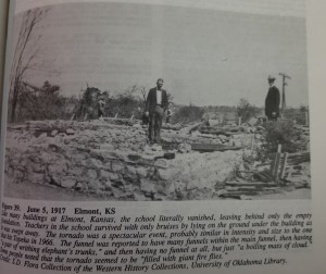
The brick schoolhouse in Elmont vanished, the debris carried well away from the site. Elmont is just seven miles north-northwest of downtown Topeka.
Credit: Thomas Grazulis - Elmont, Kansas – June 5, 1917 – Devastated the towns of Kiro and Elmont, where homes and other buildings were swept away. The school in Elmont, built of stone and mortar, simply vanished, with no debris left behind. Over rural areas, heavy farm machinery was carried great distances. This tornado passed just eight miles northwest of downtown Topeka, which was devastated by its own F5 in 1966.
- Boone, Iowa – May 21, 1918 – Two entire farms were swept away, probably over open country northeast of Boone. The southeast section of Boone was devastated and large, steel-frame industrial buildings were leveled. Cited as possibly F5 by Grazulis. This tornado was nearly concurrent with the Carroll tornado, whose F5 rating is more strongly supported.
- West Liberty, Indiana – March 28, 1920 – Devastated the village of West Liberty in Jay County. Homes were completely swept away east of Geneva, killing seven people. Some homes had their floors dislodged and moved a significant distance. This was during the devastating Palm Sunday Outbreak (the first of three major “Palm Sunday” outbreaks). Cited as a possible F5 by Grazulis.
- Arley, Alabama – April 20, 1920 – Devastated the towns of Arley and Helicon in Winston County, where many homes were swept away. Vehicles and machinery were thrown great distances. This was the same outbreak that produced the massive, devastating Waco, AL tornado, which graces this list.
-
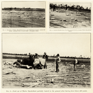
Some of the most extreme damage caused by the Blevins tornado was at the Shackleford home. In the upper left picture is all that remained of the home, which was carried 200 yds and disintegrated, the debris scattered over a 15 acre field. The home’s concrete fireplace (upper right) was shifted 3 feet. The car in the bottom image was thrown 200 yds and buried in the ground halfway up the wheels.
Credit: Monthly Weather ReviewBlevins, Arkansas – April 15, 1921 – This tornado wiped out several small communities across rural southwestern Arkansas. Blevins in Hempstead County was hardest hit. Homes were swept away and a vehicle was thrown 200 yards and partially buried in soil. At one leveled home, the concrete fireplace was shifted three feet. 34 people were killed in Hempstead County alone. Nine people died in Texas, though this was probably a series of tornadoes produced by the same supercell, rather than just a single tornado. NCDC lists this event as F5, but Grazulis lists it as F4.
- near Hettinger, North Dakota – June 24, 1923 – Two substantial ranch homes were swept away eight miles north of Hettinger in Adams County. Five people were killed there. Three more died in a home that was leveled just north of Bucyrus. This event was mentioned as possibly F5 in a recent tweet from Grazulis.

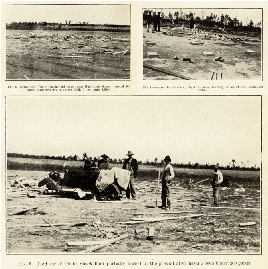
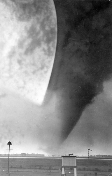
This spectacular image of the Windsor tornado was taken near the airport looking northwest toward downtown.
Credit: Windsor Star
-
- Amite, Louisiana – April 7, 1940 – Devastated Amite. A school superintendent’s large, new home was completely swept away. Both he and his wife were killed. This was the same town that was devastated by an F4 tornado in 1908. Cited as possible F5 damage by Grazulis.
- Windsor, Ontario – June 17, 1946 – Several homes were swept away as the tornado devastated the cities of Winsor and Tecumseh. One home had a portion of its foundation scoured from the ground. The tornado originally touched down in Michigan north of Detroit before crossing the Detroit River into Canada, moving east-southeast.
- Worth, Missouri – April 29, 1947 – This tornado wiped out the town of Worth. Substantial homes and some businesses were swept away in Worth, some of them made of brick, and farms were leveled just north of Denver. Considered a possible F5 by Grazulis.
1950-1999
- Clyde, Texas – April 28, 1950 – Two homes vanished just north of Clyde, the debris scattered up to a mile downstream. A refrigerator was carried half a mile and skewered through the top of a telephone pole. This was twelve years after Clyde was devastated by a probable F5 that graces this list.
- Waupaca, Wisconsin – September 26, 1951 – Three farms were swept away three miles north of town and pavement was scoured from a rural road. Cited by Grazulis as “near F5,” the tornado is listed as F5 in some older publications.
- near Moscow, Tennessee – March 21, 1952 – Steel-reinforced structures were reportedly swept away northwest of Moscow, however the report is unconfirmed. 22 homes were destroyed across the border in Mississippi near the town of Byhalia. This was part of a devastating outbreak that ravaged parts of Tennessee, Mississippi, and Arkansas.
- near Bonner Springs, Kansas – May 22, 1952 – Destroyed a dozen homes over rural areas north of Linwood and west of Bonner Springs. A bank president’s large, well-built home was swept away. Cited as possibly F5 by Grazulis
- near Cygnet, Ohio – June 8, 1953 – Swept away homes west and NW of Cygnet as it passed near the villages of Wingston and Arlington Woods. Some of these homes seem to have been of substantial construction. A bridge made of concrete and steel was destroyed north of Jerry City. This was the same outbreak that produced the devastating Flint-Beecher F5, which hit just an hour and a half later. Grazulis lists this tornado as possibly F5.
- Dispatch, Kansas – June 4, 1955 – Entire farms vanished near Dispatch. Listed as “near F5” by Grazulis.
-

This home near Walcott all but vanished.
Credit: Thomas GrazulisWalcott, North Dakota – July 2, 1955 – Eleven farms were wiped out near Walcott and at least one home vanished. The tornado carved an erratic path across farmland south of Kindred.
- near Arco, Minnesota – July 7, 1955 – Just five days after the Walcott tornado, this one “annihilated” farms near Arco. Vehicles and farm machinery were thrown hundreds of yards. It formed just south of Hendricks and moved east-southeast, passing only two miles north of Arco.
- near Hardy, Oklahoma – April 2, 1956 – A well-built home vanished near Hardy and a savings bond from the home was found over 100 miles away near Williamsburg, Kansas. This was from the same storm system that produced the Hudsonville F5 in Michigan the following day.
- near Hart Camp, Texas – April 21, 1957 – Nine homes were leveled east of Spade and Hart Camp, some of which were swept away. Cited as possibly F5 by Grazulis. This tornado took an unusual northwest track from east of Shallowater to rural areas south of Olton.

Homes throughout Fremont just vanished. However, most of them were frail and not anchored to their foundations. The writing you see indicates where homes used to be.
Credit: NOAA - Fremont, Missouri – May 21, 1957 – The beautiful little town of Fremont, tucked away in the Ozarks, was simply wiped out by this tornado. Numerous homes and other large buildings, including schools and businesses, were completely swept away. However these buildings were deemed to not have been of substantial enough construction for an F5 rating. This tornado occurred the day after the Ruskin Heights F5 ravaged the suburbs of Kansas City.
- near Martin, North Dakota – June 6, 1963 – Ravaged farmland north of Martin in Bennett County. A church “disappeared” and a house “seemed to evaporate into the air.” Listed as possibly F5 by Grazulis, this tornado is only rated F3 in the official database.
- Kanwaka, Kansas – April 12, 1964 – Devastated farmland west and northwest of Lawrence. After leveling homes near the village of Kanwaka, some farms northwest of the city were swept completely away and a pickup truck was thrown 300 yards. Widespread F4 damage occurred from near Clinton Lake to Kanwaka to the Lake View area, but the most extreme damage was on farms just north of the Kansas Turnpike. The tornado lifted four miles northwest of Tonganoxie.
-
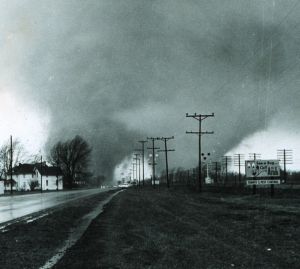
Paul Huffman’s spectacular photo has become one of the most iconic tornado images in history. It shows the tornado split into two massive funnels as it crosses US 33 into the Midway Trailer Park, which was devastated. There were two distinct damage paths where the two funnels tracked.
Credit: NOAAMidway, Indiana – April 11, 1965 – This was the spectacular twin-funnel tornado seen in Paul Huffman’s iconic series of photos taken for the Elkhart Truth. Midway Trailer Court was devastated and ten people were killed there. Homes were swept away near Middlebury after passing Midway and vehicles thrown hundreds of yards. An airplane wing from a local airstrip was found 35 miles away in Michigan. This was the first of several F5s or potential F5s during the incredible Palm Sunday Outbreak. This tornado was cited as possibly F5 by Grazulis in a later publication.
- Toledo, Ohio – April 11, 1965 – Ravaged the north side of Toledo. Fifty homes were leveled in the Creekside neighborhood alone and some were swept away. Cars, boats, and busses were reportedly thrown great distances. The original NWS survey team, led by Dr. Ted Fujita, originally rated this tornado F5 before downgrading it in later analysis. It was at least a high-end F4.
- near Swanburg, Minnesota – June 11, 1966 – Two well-built farmhouses were swept away just north of Whitefish Lake near the village of Swanburg but a lot of debris was left near the empty foundations, so this may have only been a strong F4. This tornado occurred just three days after an F5 devastated Topeka, Kansas.
- Falmouth, Kentucky – April 23, 1968 – Ravaged several rural communities across northern Kentucky, particularly Falmouth, where nearly 200 homes were destroyed. Mentioned as a possible F5 by Grazulis as several homes were swept away along the path. Evidence so far, however, is limited. This was the same outbreak that produced the Wheelersburg F5 in Ohio, whose rating Grazulis has questioned.

This spectacular image was taken by meteorologists from the NSSL, who were studying the tornado as it was in progress. This was one of the first significant research expeditions to actually “chase” tornadoes in the field and study them while they were on the ground.
Credit: NOAA - Union City, Oklahoma – May 24, 1973 – Leveled 27 homes in Union City, two of which were swept clean from their foundations. At one of the homes, an exterior garage was carried intact some distance to the north and dropped into a field while the home was wiped out. Trees were debarked throughout the path and a car was ripped apart and the debris carried into a nearby field. A gas station and a grain elevator were also leveled. This tornado was extensively photographed and studied by the National Severe Storms Laboratory in Norman, OK, who have suggested this tornado may have briefly produced F5-level damage.
- Kostroma, Russia – June 9, 1984 – Occurred shortly after the Ivanovo tornado, which was probably the strongest tornado ever recorded outside the US. Trees were ripped from the ground and debarked and a 350 ton industrial crane was blown over.
- Edmonton, Alberta – July 31, 1987 – This tornado’s rating has been extensively debated. It devastated the city of Edmonton, killing 27 people and destroying over 300 homes, many of which were swept away. Heavy tractor trailer trucks and oil tankers were thrown great distances and multiple large factories built of concrete and steel were leveled. It was the costliest tornado in Canada’s history and the second deadliest (just one short of the Regina tornado in 1912).
- Girvin, Texas – June 1, 1990 – This massive tornado, over a mile wide at times, ravaged rural ranchland between Girvin and Iraan. Three 180,000 lb oil tanks were reportedly carried three miles, skipping across the ground like stones off a pond. Two of them were tossed 600 feet up the side of a hill. Concrete was scoured from a drainage canal and extensive and severe ground and pavement scouring was observed. A semi-truck was thrown at least 400 feet from the road and the driver was killed. Another motorist was also killed.
- Oologah, Oklahoma – April 26, 1991 – Devastated the north side of Oologah, where sixty homes were leveled and some were swept away. The Oologah School Complex was largely destroyed. School buses reportedly thrown three quarters of a mile. This was from the same outbreak that produced the Andover and Red Rock F5s.
- near Allison, Texas – June 8, 1995 – This massive tornado over a mile wide hit no structures and was never surveyed by the NWS but was studied by the VORTEX research team. It was rated F4 based on severe ground scouring throughout its path, classic cycloidal scouring patterns, and extensive wind-rowing of environmental debris. However it is strongly suspected by VORTEX scientists to have reached F5 intensity.
- near Martins Mills, Tennessee – April 16, 1998 – Initially recorded as a single, long-track F5, the 1998 Tennessee tornado event was reanalyzed by NWS Nashville in 2013 and found to be three separate violent tornadoes. The middle section was the Deerfield F5 chronicled here. This was the first tornado and it was at least a high end F4 as it raked through rural areas across Wayne County. Well-built homes along “Lay Creek Rd” (possibly JV Lay Road 5 miles NE of Martins Mills) were swept away. The reanalysis report issued by NWS Nashville admits that the initial Wayne County tornado may have also been an F5.
-
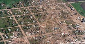
An aerial view of some of the incredible devastation in Spencer. Some of the homes in this picture have been swept away.
Credit: Argus LeaderSpencer, South Dakota – May 30, 1998 – This tornado devastated Spencer. Numerous homes were destroyed and some were swept away. An apartment building was also leveled and the town’s water tower was toppled to the ground. A Doppler on Wheels (DOW) mobile radar unit measured winds of 264 mph at 160 feet above ground level, indicating winds likely near or exceeding 200 mph at ground level.
- Mulhall, Oklahoma – May 3, 1999 – Mulhall was devastated by this monstrous tornado. Well-built homes were swept away and one had a portion of its foundation scoured from the ground. 60-70% of the town was severely damaged or destroyed. The local elementary school was leveled and the town’s water tower was knocked down (shades of Spencer). DOW mobile radar units measured winds in excess of 260 mph inside the funnel. Some estimates ran as high as 297 mph. At its peak, it was an incredible 2.2 miles wide, making it the largest tornado ever recorded at the time (the Hallam, NE tornado in 2004 broke that record). Scientists that were there during the outbreak said that this tornado was just as violent as the legendary Moore tornado that hit hours earlier, it just hit less. There is strong evidence supporting this tornado being an F5 and it may warrant an upgrade in the future. It, like the outbreak as a whole, has been extensively studied.
- Hedwigs Hill, Texas – May 11, 1999 – Another massive, mile-wide tornado, this one struck rural Mason County, Texas just a week after the Oklahoma tornadoes. Two homes near Hedwigs Hill north of Loyal Valley vanished, the debris carried well downstream. Remnants of a pickup truck was found three quarters of a mile from where it originated. A 720 foot wide section of asphalt was scoured from a local road and severe ground scouring was reported throughout the tornado’s path. Numerous trees were shredded and debarked, and cattle carcasses were reportedly stripped of their hides. Meteorologist Bill Hecke likened damage to the aftermath of the Jarrell tornado, which produced some of the most extreme tornado damage ever observed, and which he personally witnessed. This evidence makes it, along with Mulhall, one of the strongest upgrade candidates.

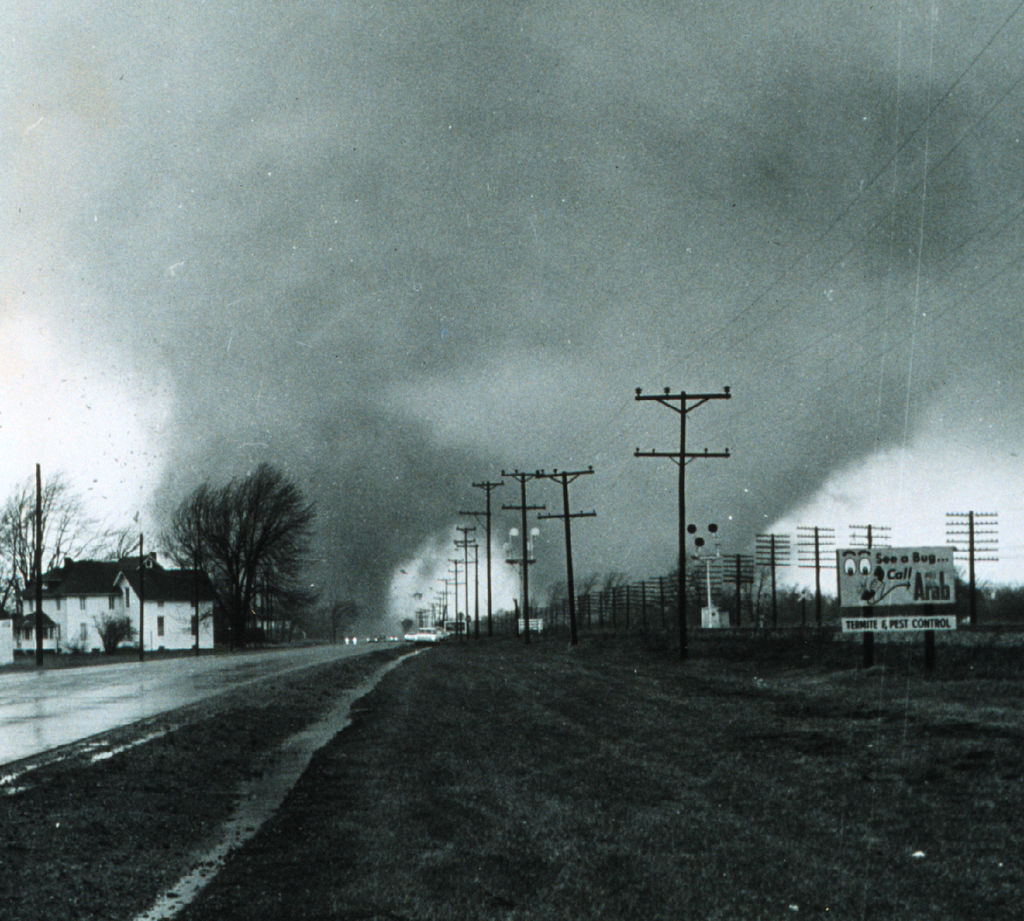
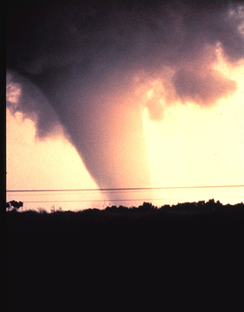
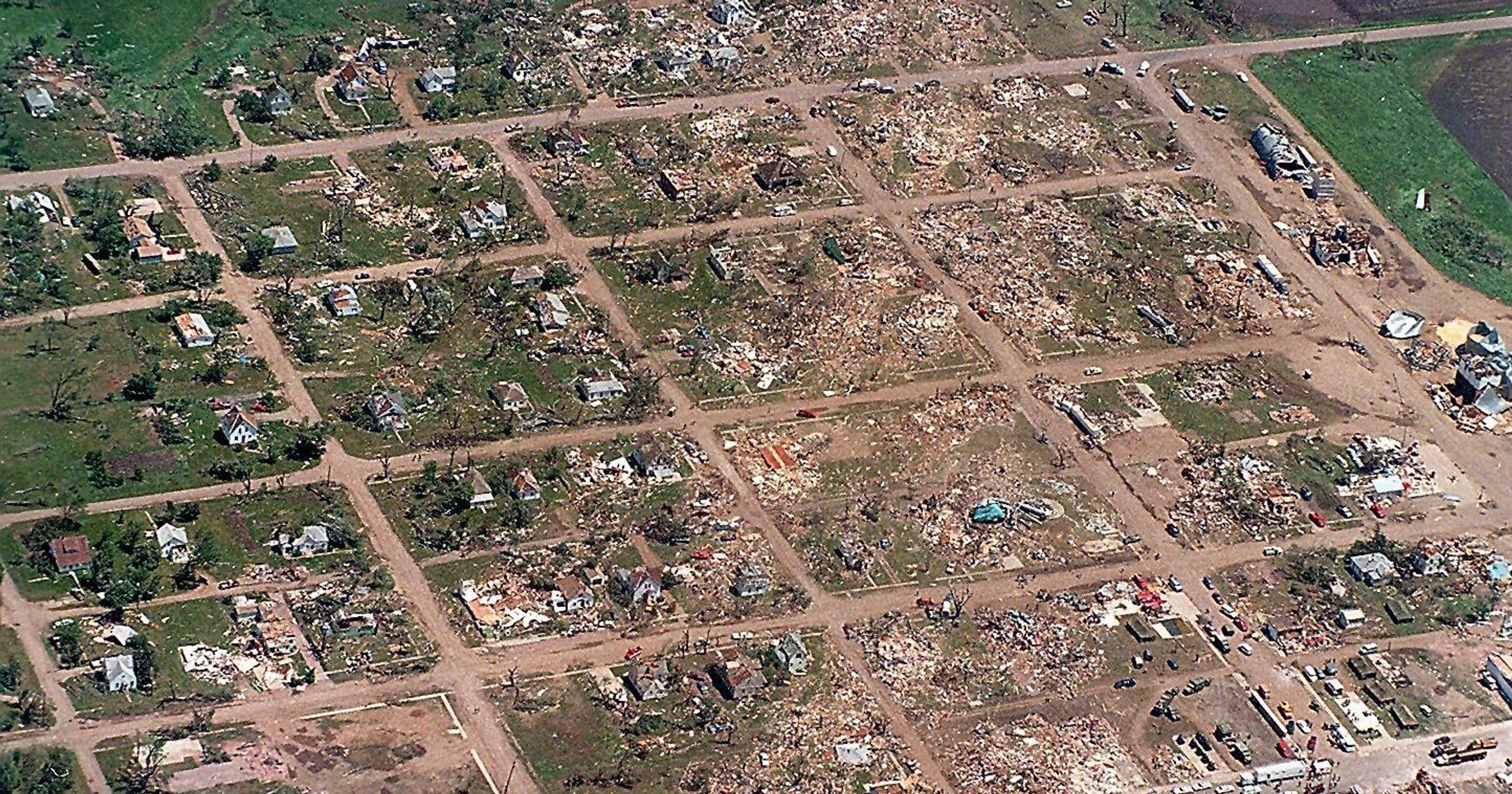
2000-present
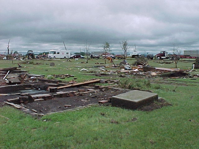
Some of the most extreme damage in Manchester; some homes were simply annihilated. However, this home likely wasn’t well anchored.
Credit: NOAA
-
-
-
- Manchester, South Dakota – June 24, 2003 – The little village of Manchester was wiped off the map by this tornado and it’s the most recent example of a town being abandoned due to tornado damage. Three well-built homes there were completely swept away and trees were debarked. The tornado left deep cycloidal patterns in neighboring fields with intense topsoil disruption typically observed only in extremely intense tornadoes. Scientist Tim Samaras, who was killed in the 2013 El Reno tornado, deployed a probe that measured a 100 millibar pressure drop inside the tornado; the greatest pressure drop ever recorded on Earth. The section of road the probe was sitting on was scoured from the ground but luckily the probe was recovered nearby. Officially a high-end F4, the NWS admitted in their final report that winds may have been as high as 260 mph.
- near Hill City, Kansas – June 9, 2005 – A DOW mobile Doppler radar measured winds of about 200 MPH over open country south of Hill City. Damage was rated F2. Friction probably kept this tornado below F5 intensity at the surface.
-

Not only was this home in Bridgeport swept away, this set of concrete stairs was ripped from the foundation and left on the slab. Yet none of the homes around it suffered damage anywhere near this extreme.
Credit: NOAAStuttgart, Arkansas – May 10, 2008 – A DOW mobile Doppler radar measured winds of 204-226 MPH over rural areas SE of Stuttgart. This tornado caused widespread EF3 damage in Stuttgart and was estimated to have been at least 1.5 miles wide. Like the previous event, friction likely kept this tornado below EF5 intensity at the surface, but it was likely capable of producing EF4 damage (NOAA switched to the Enhanced Fujita Scale in 2007).
- Bridgeport, Alabama – April 27, 2011 – A well-built home was completely swept away in Bridgeport and a set of concrete stairs was torn from the foundation and left on the slab. The corner of the slab was partially pulled up. However scouring was minimal and adjacent homes suffered relatively minor damage. Another example of just how fickle tornadoes are.
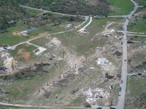
Aerial view of some of the incredible damage in the Cherokee Valley area north of Ringgold. These were well-built homes that simply disintegrated. In particular, the two on the left have major scouring with no debris remaining, which is indicative of EF5 level damage.
Credit: NOAA - Ringgold, Georgia – April 27, 2011 – Well-anchored homes were swept away in the Cherokee Valley subdivision north of Ringgold, however shrubs and bushes surrounding the slabs were left largely intact, so the NWS elected to conservatively rate the tornado EF4. It would’ve remarkably been Georgia’s first F5/EF5 tornado in recorded history, despite over 30 F4/EF4s. Given the extreme damage, it very well could’ve been.
- Bennington, Kansas – May 28, 2013 – A mobile Doppler radar unit measured winds of 247 mph within the tornado funnel. Severe ground scouring was also observed. No significant structures were hit. This was just three days before the epic El Reno tornado in Oklahoma.
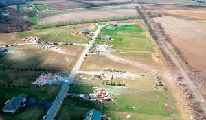
Aerial view of some of the extreme damage in Rochelle.
Credit: NOAA- Rochelle, Illinois – April 9, 2015 – Several well-anchored homes were swept away with extensive scouring in rural neighborhoods near Rochelle. Adjacent bushes were not stripped, as would be expected with an EF5 tornado, so the NWS survey team elected to conservatively rate the tornado EF4. However, the yards of some of the swept away homes were stripped of grass and one had its concrete walkway displaced a few inches. More homes were swept away on nearby farms and a reinforced concrete silo was obliterated. This tornado was probably EF5 and will eventually be added to this list, but I will need corroborating support from an expert before that can happen.
- near Sulphur, Oklahoma – May 9, 2016 – An RaXPol mobile radar unit measured winds of 218 MPH over an open field with no structures impacted. Friction probably kept this tornado below EF5 intensity.
- Richland Township, Kansas – May 24, 2016 – A DOW mobile Doppler radar unit measured winds of up to 201 MPH over an open field with no structures impacted. This tornado hit just five miles SW of Dodge City. As with most of the radar measured events, friction probably kept this tornado sub-EF5.
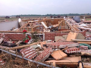
This was the very well built farmhouse that was utterly obliterated by the Chapman tornado. Normally, an EF5 tornado would carry the debris some distance away, but this home was so well constructed that the tornado may have been EF5 anyway.
Credit: NOAA - Chapman, Kansas – May 25, 2016 – A well-anchored brick farmhouse was swept away and its foundation was severely cracked. Even the subfloor was ripped from the foundation walls, exposing the basement. Chunks of the foundation wall were actually torn loose, exposing the rebar. Vehicles and heavy farm machinery thrown great distances and obliterated. A section of steel railroad track was bent by the force of the winds. Because a large amount of debris remained near the empty basement, the NWS elected to conservatively rate the damage EF4. However, members of the NWS survey team admitted that had the tornado struck Chapman proper, it “could very well have been” rated EF5. And because the home was so well-constructed, this may have been EF5 damage. This tornado may be added to this list in the near future.
-
-
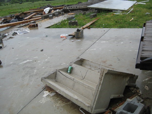

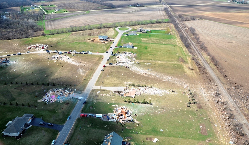
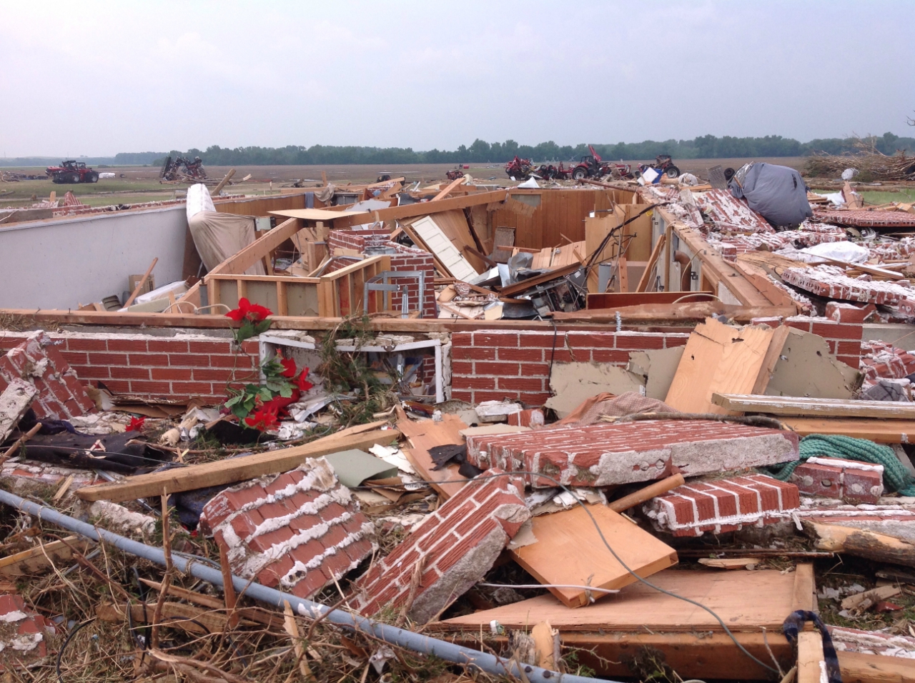

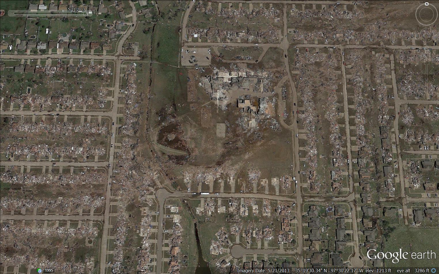