
Man, it’s hot out there! Summer is in full swing and many parts of the US are experiencing their first significant heat wave of the season. That begs the question: what causes a heat wave? Well, the short answer to that is generally a large, tropical high pressure system. A high pressure means air is converging high in the atmosphere and sinking down to the surface, where it spreads out, or diverges. This sinking air has a drying effect, clearing out clouds and leaving us to roast in the summer sun. High pressure systems can also bring in much warmer air from the south, further intensifying the heating. It also has a bad habit of killing off any cooling breezes. In the southeast, however, the drying effect of the sinking air is limited by the tropical influence of the Gulf of Mexico and Atlantic Ocean, with moist air coming off the water. This limits how high temperatures will climb and allows some cloud formation, but it also greatly increases dewpoints and relative humidity. This causes much higher heat indices, or apparent temperatures. In the desert southwest, this tropical moisture is absent, which keeps the relative humidity down but allows temperatures to soar well into the hundreds.
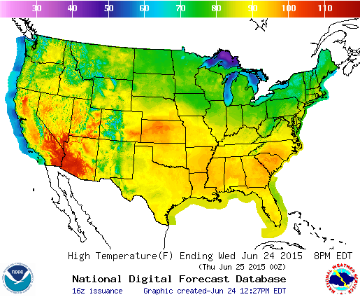
Today’s high temperatures, showing the heat spread across the southeast and southwest, as well as the plains of Kansas.
Source: NOAA
The traditional setup for a heat wave is much like the reverse of a cold wave. In the winter, big Arctic high pressures sweep down from Canada, bringing frigid Arctic air with it. The lack of cloud cover allows the Earth’s surface to lose a lot of heat at night through radiative effects and causes temperatures to plummet. In a heat wave, strong tropical high pressures build in from the south (in the southeast, they can also come from the west or southwest, or the Atlantic to the east), bringing in warmer air from the deserts of northern Mexico, or the tropical Atlantic or Gulf of Mexico. As I mentioned earlier, the clearing of clouds during the peak of the day allows for vastly increased solar radiation. In the Deep South, temperatures closest to the coast are moderated by the presence of the ocean. However, once you move farther inland, there is a stronger continental influence with just enough tropical air to strongly impact heat indices. What you end up with over the interior Deep South is hot and sticky weather with the ever-present chance of thunderstorms.
So what’s happening now? The heat wave in the southeast is cresting today and into tomorrow and is expected to break by the weekend as the high pressure begins to break down. Heat index values as high as 110 can be expected over portions of the South. This intense heating plus the presence of tropical moisture brings with it the possibility of thunderstorms, particularly in the peak of the afternoon. These thunderstorms can develop quickly and are very difficult to predict.

The west is about to really heat up as a high pressure moves north and sets up an intense heat wave.
Source: The Weather Channel
While the South may be cooling off this weekend, the west will be getting even hotter. This one may set records. A high pressure is moving north-northwest from Mexico and bringing intense heat with it. The high temperature in Boise, Idaho is expected to be 107 deg F both Sunday and Monday. Parts of eastern Washington, Oregon, and Idaho could approach 110 deg F. Missoula’s June record of 100 deg F, which has stood for 97 years (it was matched in 1937), is expect to fall, with 102 deg F forecast for Sunday. Nearby Kalispell has never seen triple digit temperatures in June. They’re expected to reach 101 on Sunday. Spokane, Washington’s all time record is 108 deg F. It’s expected to reach 105 on Sunday. Portland, Oregon’s June record is 102 deg F, set in 2006. They’re forecast to reach 101 on Saturday. That record could be in jeopardy. Reno, Nevada’s June record is 104 deg F and they could hit 102 both Friday and Saturday. Salt Lake City’s June record is 105 deg F and they are expected to see 102 on Monday and Tuesday, the final two days of June. Many areas could see one hundred degree temperatures for several consecutive days, threatening further records. Triple digit heat is expected to reach as far north as southern Canada.
So how do you beat the heat? Stay inside as much as possible, but if you must be outside, drink lots of water and take plenty of breaks. Limit time outside as much as possible. Also remember to wear plenty of sunscreen. And watch out for thunderstorms. Remember, when thunder roars, go indoors!
