In A Blink, Their World Vanished
by: Eric Brown
Langleyville, Illinois – April 24, 1880
This tornado ripped through farmland west and northwest of Taylorville, Illinois. It formed west of Palmer and moved northeast. Arguably the greatest destruction occurred near the village of Langley (now Langleyville) just three miles west of Taylorville. Entire farms disappeared. Numerous homes were destroyed and some completely vanished, making it impossible to tell where they once stood. The Willow Ford Bridge across the south fork of the Sangamon River was destroyed and some of its timbers were carried a full mile away. A rail was driven four feet into the ground, the corpse of a 300 pound hog sticking off the end. Members of the Langley family, who bequeathed their name to the town, were killed when their house was destroyed. Bodies of people and farm animals were carried up to half a mile. The destruction continued as the tornado passed to the northwest of Taylorville. Several homes were leveled at the southeast edge of Sharpsburg before the tornado lifted just a few miles to the northeast. In all, six people were killed and many more were injured. A massive F4 tornado had wiped out the town of Marshfield, Missouri just six days earlier, killing 99 people.
Hopkins, Missouri – June 12, 1881
This tornado passed through open country a few miles south and west of Hopkins, obliterating several farmhouses and killing two people. It formed three miles west of Burlington Junction and moved northeast, passing near Dawsonville and two miles southeast of Clearmont. The tornado intensified after passing Clearmont, wiping out two farms six miles west of Hopkins. Two horses were reportedly carried a quarter of a mile. One James Young and his wife were killed when their house was destroyed. They and the remains of their house were blown 50 yards away. The tornado lifted near the Iowa border.
New Ulm, Minnesota – July 15, 1881
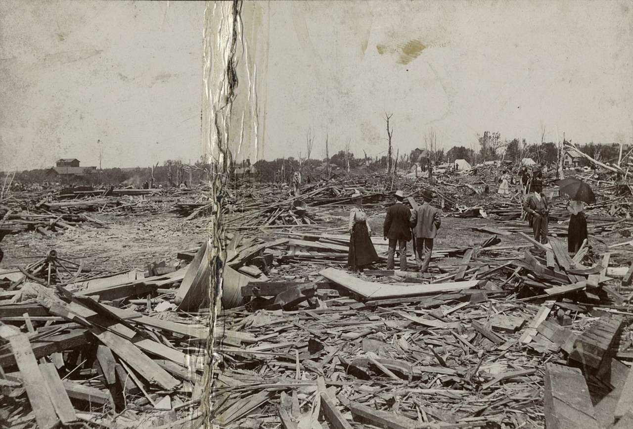
The city of New Ulm, Minnesota was founded by German immigrants shortly before the Civil War at the confluence of the Minnesota and Cottonwood Rivers. It was a popular frontier trading post and was at the forefront of the Indian Wars around that time. The heritage of its founders attracted many European immigrants to the town. By 1881, it was a bustling city of several thousand. The tornado that hit here that Friday in July remains one of the state’s most memorable disasters.

A view of the devastation in New Ulm.
Credit: Minnesota Historical Society
It was oppressively hot that day with temperatures soaring into the 90s with stifling humidity. A slight southerly breeze offered little relief. By 3pm, thunder could be heard in the distance and the citizens of New Ulm hoped a summer downpour would cool things off. What they got instead was horrible devastation. A tornado touched down just west of Bird Island, some 40 miles northwest of New Ulm, and moved southeast. It gradually grew into a monster.
The devastation that was to come in New Ulm got all the attention, but this tornado’s most extreme violence happened over farmland northeast of Fairfax. Five entire farms, including substantial farmhouses, across rural Wellington Township simply vanished. Hardly any debris was left behind. Somewhat miraculously, only two people were killed. The devastation continued into neighboring Cairo Township, where a family of five was wiped out when their farmhouse was annihilated. Farther south, the village of West Newton along the river upstream of New Ulm was devastated. Nine homes were leveled and the town faded out of existence within 30 years. Five more people died there.
Survivors in West Newton reported seeing multiple funnels snaking across the plains and then reforming into a single huge funnel and turning sharply east-southeast toward New Ulm. It ripped through the west side of New Ulm as a monstrous F4 at 4:45pm, causing incredible devastation. Much of that part of town was leveled, including large brick buildings. The major boulevards of Broadway and Minnesota Street in the heart of the city were filled with debris and impassible for days. 47 buildings in New Ulm were wiped out and over two hundred were damaged. Miraculously, just six people were killed in New Ulm. The tornado’s overall toll of twenty is also remarkable, considering the devastation. And shortly after leaving New Ulm, the tornado retreated back into the clouds.
As incredible and devastating as the New Ulm tornado was, it was overshadowed by the even more devastating tornadoes that ravaged Minnesota over the next few years. Just two years later, the city of Rochester was ravaged by its own F5, and in 1886, an F4 devastated the cities of Sauk Rapids, St. Cloud, and Rice, killing 72. It was the worst tornado in Minnesota’s history. The New Ulm tornado that started it all faded into obscurity.
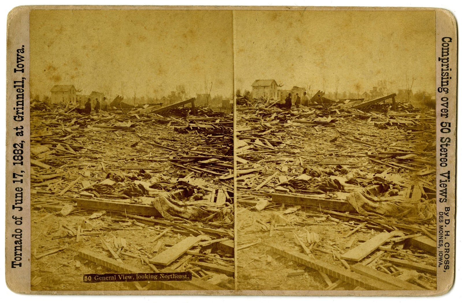
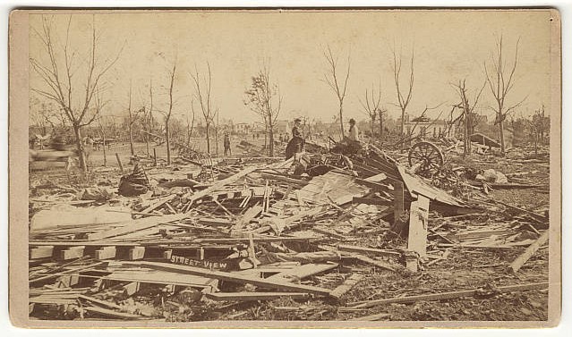
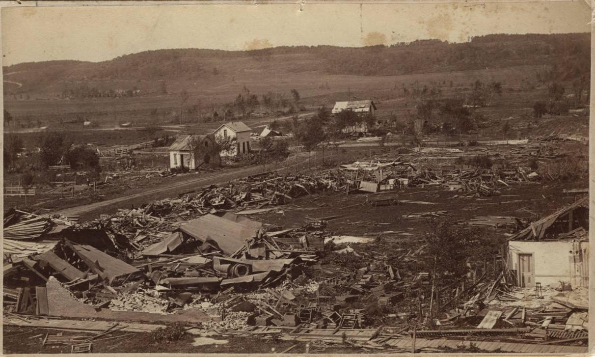
Grinnell, Iowa – June 17, 1882
Half of Grinnell was reduced to splinters.
Credit: New York Public Library
This massive, powerful family of tornadoes devastated a huge swath of central Iowa. It first touched the earth over rural farm country southeast of Jefferson and moved east-southeast. Ten people died as entire farms were wiped out north of Rippey and Berkley. People in Ogden saw the tornado as it snaked through the countryside to the south at about 8pm. The devastation continued unabated as the tornado passed south of Luther and into Story County, where more farms were obliterated near Kelley. In all, 16 farms across rural Boone and Story Counties were annihilated. The storm began to curve more to the southeast and became more intermittent. It crossed southwestern Marshall County south of Rhodes and moved into Jasper County. The tornado intensified as it passed north of Baxter and Rushville, ravaging farmland in Rock Creek Township as it bore down on the Poweshiek County line. The worst, however, was yet to come.
Grinnell was a modest town of a few thousand along the Chicago, Rock Island & Pacific Railroad. It was famous as a stop on the Underground Railroad. The town’s founder, JB Grinnell, helped many slaves escape to freedom in the north. It also is home to Grinnell College, a prestigious institution which predates the town’s foundation. June 17, 1882 would change the town forever.

The ruins of Grinnell College after the tornado. This building once had three floors and a bell tower.
Credit: New York Public Library
It was a typical Saturday evening in Grinnell. Most people had turned in for the night. By about 8pm, a terrific storm of heavy rain and brilliant lightning descended on the town. It drowned out the roar of the monster coming in from the northwest. At 8:30, the tornado tore right through the heart of Grinnell with devastating effect. Half the city was destroyed and dozens of people were killed. Grinnell College was left in ruins. All that was left of the sprawling main building, made of brick, was its outer walls. Its main tower collapsed and took out a giant center section. Its bell was thrown into an adjacent field. Three students died in the wrecked dormitories. Just east of town, a train engine and 14 freight cars were thrown from the tracks, killing two people. In all, 39 people died in Grinnell alone and 73 homes were destroyed. Flooding rains inundated the town before, during, and after the tornado, leaving the ruins awash in up to a foot of water, hampering rescue efforts.
Continuing southeast, the tornado tore through the north side of Malcolm leveling that half of town. Rows of homes were wiped out and ten people died, a remarkably low number considering the tornado hit completely without warning when many people were asleep. The tornado finally lifted near the town of Parnell in Iowa County. In all, 68 people were killed and hundreds were injured. Debris from Grinnell was reportedly found over 100 miles to the northeast in Wisconsin. Another devastating tornado apparently tracked parallel to and to the north of the main tornado in Boone and Story Counties, ravaging farms near Ogden and Luther. The Grinnell tornado was Iowa’s worst tornado in 22 years. Sadly, it would be surpassed just 11 years later by the Pomeroy tornado, also an F5, which killed 71.
Rochester, Minnesota – August 21, 1883
A destroyed home in Rochester.
Credit: Olmsted County Historical Society
It was a hot, humid day in Rochester, Minnesota. Contemporary writers described the air as “smoky and oppressive.” According to Joseph Leonard in his History of Olmstead County, Minnesota, “The heavens were overcast with clouds of a dull, leaden line, and there were, apparently, three strata, all moving in different directions.” This indicates the presence of strong vertical shear conducive to the formation of tornadoes. At around 3pm, dark clouds brought gusty winds and light rains but was gone as soon as it came. It was around this time that, unbeknownst to the people of Rochester, an F3 tornado struck the Pleasant Grove area ten miles south of the city. At around 5pm, more dark clouds began to gather to the southwest…
This brick commercial building was completely flattened by the tornado.
Credit: Rochester Post Bulletin
The Rochester tornado formed a few miles northwest of Hayfield and curved northeast, steadily intensifying. Ten farms northeast of Hayfield were leveled before the tornado moved into Olmsted County. In Rochester, the clouds grew darker and began to swirl, backlit by an eerie green glow. The tornado was preceded by a loud roaring sound that sent many people running for basements and storm shelters. This undoubtedly saved many lives. The tornado raked by Salem Corners and slammed into the north side of Rochester as a mile-wide F5. Rows of homes and businesses in the heart of the city were annihilated. Hardest hit was working class housing on the north side of the railroad tracks where the devastation was virtually complete. The business district along what is now Civic Center Drive was also ravaged. A passenger train traveling at high speed through Rochester was thrown from the tracks, killing several passengers, and an iron railroad trestle was destroyed. A wooden board was found speared through a tree.
After leaving Rochester, the devastation to farmland continued. Several farms were wiped out and multiple farmhouses vanished. One home was lifted from its foundation and carried into a nearby field, where it was dashed to pieces. Grain stalks were pulled from the ground as fields were scoured. The tornado finally weakened as it passed near Viola, lifting a few miles east of that town.
In all, 37 people were killed and 135 homes were destroyed. Rochester did not have a hospital at the time, so the Rommel Hall dance hall was turned into a makeshift emergency room. Dr William Mayo and his two sons, William Jr. and Charles, took charge of caring for patients. Realizing the need for a hospital in Rochester, the Mayos banded together with the Sisters of St. Francis to form St. Mary’s Hospital. This ultimately led to the creation of the Mayo Clinic.
Oakville, Indiana – April 1, 1884
The small community of Oakville, Indiana was virtually wiped out of existence by this large and powerful tornado. It formed about three miles northeast of Mechanicsburg, moving erratically northeastward, eventually curving more to the east. It ripped through Oakville at around 5pm as a half mile wide F5 and the town was obliterated. Out of 45 houses, just five remained standing. Entire sections of town simply vanished. Debris from Oakville was scattered for miles over open farmland to the east. The remains of one disintegrated home were found two and a half miles away. Heavy oak sills were carried half a mile and pieces of homes as far as three miles. The town’s large saw mill and an adjacent warehouse were destroyed. Just five people were killed in Oakville. Two of the victims were carried half a mile into a wooded area. However, given the totality of the devastation, it’s somewhat miraculous the death toll was that low. Survivors reported that the tornado was spectacularly visible, backlit by an eerie green glow, and most of the townspeople were able to seek shelter. It continued to cause heavy damage over rural areas east of Oakville, passing north of Luray and through the Mount Pleasant area before probably lifting a short distance east of what is now Prairie Creek Reservoir. This was one of the first major tornadoes where the famous green glow was reported.
Easton, Minnesota – June 15, 1892
This tornado touched down just east of Delavan and moved east northeast, steadily intensifying across rural Faribault County. It devastated several farms northeast of Easton, hurling timber up to three miles away, leaving large boards embedded in the ground. Large farmhouses vanished and seven people were killed in this area. The tornado then turned more eastward, leveling homes south and east of Minnesota Lake. Slightly weaker, the tornado tracked north of Freeborn and northwest of Hartland, where two more people were killed. It passed between Ellendale and Geneva before finally lifting four miles west of Blooming Prairie. The tornado had traveled over 40 miles across the southern Minnesota countryside. Four people were injured when a farmhouse was destroyed near the end of the track. In all, nine people were killed and dozens of buildings were destroyed.
Willow Springs, Wisconsin – May 22, 1893
This tornado devastated farmland across rural Willow Springs township north of Darlington. It formed two miles northwest of that town and moved northeast, ravaging open country east of Calamine. Entire farms roughly four miles north-northeast of Darlington simply vanished. Two people were killed when farmhouses were wiped out. Passing northwest of Fayette, the tornado destroyed more homes in Moscow Township, where another person was killed, before lifting.
Pomeroy, Iowa – July 6, 1893
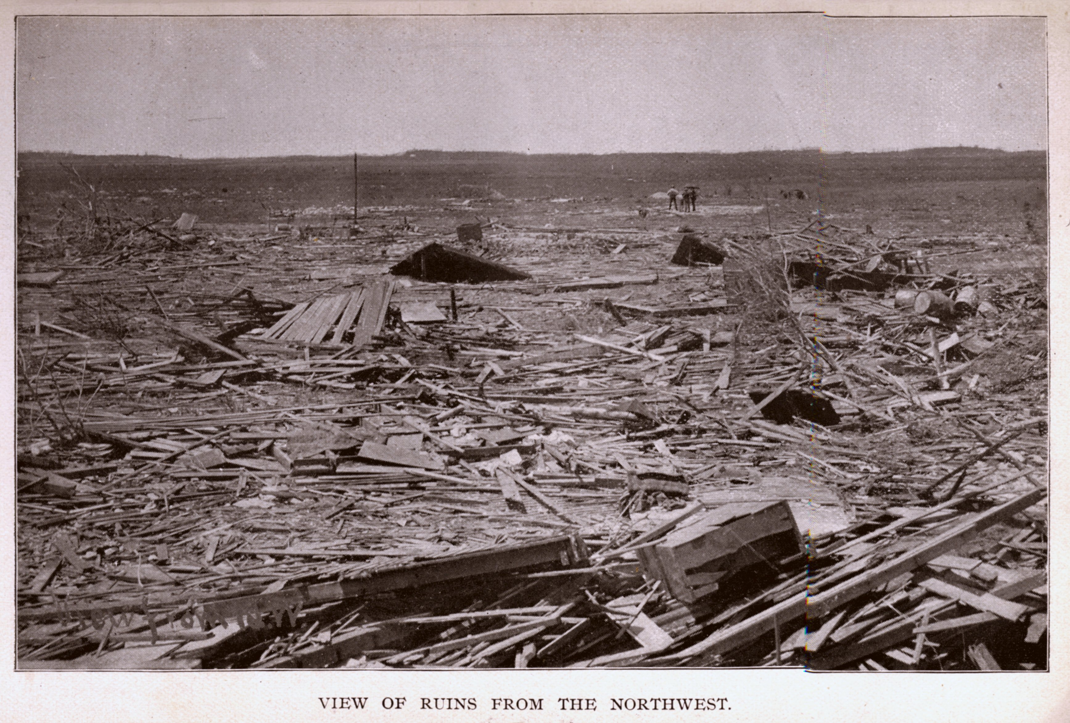
Debris from Pomeroy strewn across a neighboring field
Credit: NOAA
This large, multi-vortex tornado devastated a huge swath of north-central Iowa. It formed just north of Quimby in Cherokee County and moved just south of due east. Homes were swept away in every county it passed through. Six people from one family died in Cherokee County when their house was destroyed. A schoolhouse northeast of Quimby was wiped out and a nearby well pump, along with 4o feet of pipe were pulled out of the ground. The Pilot Rock bridge, built of heavy iron trusses and girders, was torn from its anchors and dropped into the Little Sioux River. The devastation continued as the tornado passed south of Aurelia and Alta. Numerous rural homes were obliterated. The ruins of one home were reportedly carried 100 yards into a nearby field. It roared over Storm Lake as a large and powerful tornado, sucking water high into its funnel and dropping it onto the shoreline. Shifting more to the southeast, it passed south of Newell and Fonda, flattening homes along the way. Fields in the path of the tornado were completely stripped of vegetation and several inches of topsoil was churned up. The worst, however, was yet to come.
This was all that was left of the brand new Lutheran Church at Seneca and Third. Amazingly, the church was rebuilt and still stands today at the very same intersection.
The railway town of Pomeroy was inundated by rain in the half hour that preceded the tornado. In the darkness and deluge, few had any idea of the horror that was coming. A lucky few were able to catch a glimpse of the funnel in flashes of lightning, sending them running for storm shelters. At 6:45 pm, the tornado slammed into Pomeroy. The town was decimated. Eighty percent of homes were heavily damaged or destroyed. Rows of homes along Seneca Street vanished. At the corner of Seneca and Third Street, a large, well-built Lutheran church was obliterated. Only the bell remained intact. The tornado chewed through the heart of the town, wiping out homes and businesses along Second and Third Streets. A brick drug store on Second with walls a foot thick was flattened and the ruins dumped in the street. Large boulders were reportedly thrown hundreds of yards and swaths of trees were shredded and debarked. 44 people died in Pomeroy alone. 27 others died elsewhere in the tornado’s track. However, many people survived by taking shelter in caves and bunkers. The tornado lifted just three miles southeast of the town it had just destroyed.
Plum Creek, Iowa – September 21, 1894
Part of a small, but powerful and destructive late September outbreak across Iowa and Minnesota, this large, long-track tornado devastated rural Kossuth County. Forming about three miles north of Whittemore, the tornado moved east-northeast, devastating farmsteads across the East Fork Des Moines River Valley. It tore across Lotts Creek, Union, and Plum Creek townships north of Algona before turning more northeastward. The tornado clipped Hancock County northwest of Woden before moving into Winnebago County. Turning more to the north, it flattened homes between Buffalo Center and Thompson. The tornado crossed the border into Minnesota and lifted near the town of Kiester. At least 13 people died in Kossuth County and at least ten farms were virtually obliterated. Five had “little left to show that a farm once existed on the site.” One other person was killed near Buffalo Center after a home was “wiped out of existence.” This event was likely a tornado family, or a series of tornadoes produced by the same storm cell.
Halstead, Kansas – May 1, 1895
The first few days of May, 1895 saw some really powerful tornadoes hit the central part of the country. It started with an epic tornado in south-central Kansas. This part of Kansas surrounding Wichita has seen some of the most powerful tornadoes in history. F5 tornadoes struck this same area in 1917, 1955, 1958, 1990, and 1991. The massive 1927 tornado struck not far to the west. This region and its history are discussed further in the section on the remarkable 1990 event.
This tornado formed in Sedgwick County on the south bank of the Arkansas River near Mount Hope and moved northeast. Jumping the river into Harvey County, the tornado proceeded to devastate the farm country across the western portion of the county. At least 25 farms were destroyed and some were simply wiped from the face of the earth. Numerous large, well-built homes were completely obliterated, at least one of which was newly constructed. A rural school was leveled moments after a teacher hurried students into a storm cellar.
The storm passed three miles west of Halstead, scattering the ruins of homes and cattle carcasses across the landscape. Debris was carried miles downstream. The tornado was nearly a mile wide in this area and looked like a low cloud rolling across the horizon. It moved very slowly as it passed Halstead, enough to allow a passenger train moving west out of town to stop and allow it to pass. At least eight people were killed and many more injured. The eight deaths were from just two families and it’s been speculated that because the tornado was so large, people in its path didn’t recognize what it was until it was too late. This phenomena has been reported by survivors of many similarly large tornadoes. The tornado continued northeast, lifting near the McPherson County line between Moundridge and Hesston.
Carmel, Iowa – May 3, 1895
Just two days after the Halstead tornado, another F5 struck rural Sioux County, Iowa. May 3 saw a much more substantial outbreak, with at least seven significant tornadoes (F2 or greater) reported across Iowa and South Dakota. The tornado touched down three miles north of Ireton and moved northeastward across open country west of Sioux Center. Four schoolhouses were hit, two of which were obliterated, killing several teachers and students. School children were reportedly carried up to half a mile. Nearby farms were decimated, with several people dying in homes that all but vanished. The tornado passed about four miles north and west of Sioux Center, just southeast of the tiny farm village of Carmel and very near where the Sioux Center Municipal Airport sits today. The most extreme devastation was over open country south of Carmel and west of Sioux Center. It would lift about two miles southwest of Hull. The tornado killed 15 people and completely destroyed dozens of buildings.
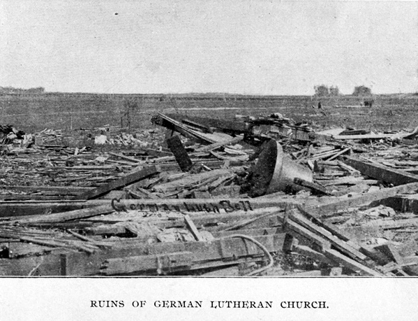
Sherman, Texas – May 15, 1896
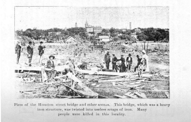
The remnants of the Houston Street bridge. Solid iron beams were mangled and twisted.
Credit: gendisasters.com
May of 1896 was the third worst month of tornadoes in history, behind only April, 1936 and the Tri State Tornado in March, 1925. 484 people died in a devastating series of outbreaks that ravaged the central United States over a ten day period. It began on May 15, when several destructive tornadoes ripped through Texas, Oklahoma, and Kansas. At the time, there was a strong ridge of high pressure over the eastern US and a deep low pressure system swept down from Canada into the Great Plains, causing very strong temperature and pressure differences across the southern Plains and Mississippi Valley. There was very deep moisture and strong wind shear across the Red River Valley of Texas and Oklahoma, creating ripe conditions for strong tornadoes. There were likely many more tornadoes that day that weren’t recorded.
A narrow but powerful tornado, this one devastated the city of Sherman. It touched down about three miles east of Pilot Point, where several farmhouses were knocked from their foundations. Moving northeast, the tornado grew into a monster. Entire farms west of Howe were annihilated. The tornado narrowed considerably to a mere 60 yards as it passed near Dorchester and turned due north. It remained incredibly powerful, however, and tore through the west side of Sherman shortly before 5pm, causing incredible devastation. The tornado was preceded by a torrential downpour of rain, which hid the tornado from view until it was too late.

Dozens of homes on the west side of Sherman were obliterated.
Credit: Sherman Herald Democrat
Fifty homes were destroyed and twenty all but vanished. Some reported seeing houses lifted in the air and dashed to pieces. An iron bridge on Houston Street, weighing hundreds of thousands of pounds, was torn to pieces and carried away. An iron beam from the bridge weighing 200 pounds was thrown 225 feet north and buried several feet into the ground. A nearby cemetery was wiped out. A 500 pound stone from a mausoleum was flung 250 yards. Bodies of people and farm animals were scattered hundreds of yards from where they originated. A trunk lid was reportedly carried 35 miles north. Grassy fields and the yards of homes were stripped bare and trees were taken down to their stumps or completely debarked. The black portion of town was particularly decimated. 73 people died, nearly half of those in the negro district. It was Texas’s deadliest tornado for all of six years, until 1902 when the town of Goliad was wiped out by an F4, killing 114. The tornado lifted near Knollwood just north of town.
Seneca, Kansas – May 17, 1896
Tornado damage near Seneca.
Credit: gendisasters.com
Just two days after the devastation in Sherman, more powerful tornadoes touched down in Kansas. This monstrous family of tornadoes tore a path of destruction over 100 miles long and a mile wide across northeastern Kansas. Exactly where the tornado first touched down is unclear, but its origins have been traced to as far away as Clay County. It was first definitively observed three miles northeast of Clifton in Washington County, moving ENE. The tornado remained of relatively mild intensity as it moved over open farm country near Kimeo and Chepstow. Moving into Marshall County, it passed south of Waterville and Blue Rapids and began turn gradually more northeast. It passed just a mile south of Frankfort, where residents watched the funnel move across the open prairie.
From Marshall, it crossed into Nemaha County, moving northeast, now steadily gaining intensity. It slammed into Seneca as a mile-wide F5. The city was devastated. The entire central portion of town was virtually demolished. The Grand Opera House was reportedly “swept away.” The Nemaha County Courthouse and a large, brand new schoolhouse were also leveled. Six people were killed in Seneca, a miraculously low number given the extent of the damage. But the tornado wasn’t done. It continued east-northeast, striking the town of Oneida, where it was almost as devastating. Another six were killed there. Next it struck the north side of Sabetha, where twenty homes were destroyed and three people died. Moving into Brown County, it passed just northwest of Morrill before devastating the town of Reserve. Five people died there and all but three buildings were damaged or destroyed. Weakening, the tornado curled more to the north and crossed the border into Nebraska, where it lifted along the banks of the Big Nemaha River near the town of Preston.
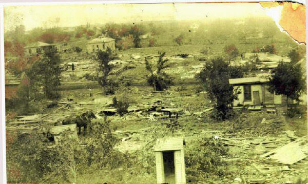
Ortonville, Michigan – May 25, 1896
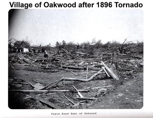
Damage along Coats Road near Oakwood.
Credit: Dearborn Press and Guide
After the tornadoes of the 17th, the activity cooled off somewhat. The low pressure system that spurred the original activity shifted off to the east. However, another wave was coming. The first of a new series of fast-moving shortwaves came down from Canada on May 24 and ignited new activity over the upper Midwest. A shortwave is just a low pressure trough that isn’t as deep north to south. An F4 caused major damage to the towns of Bondurant and Valeria, Iowa, north of Des Moines. 21 people were killed. The following day, the outbreak really kicked back into gear as the shortwave moved into the Great Lakes region.
Until the Flint tornado of 1953, this was the most devastating tornado in Michigan’s history. It touched down north of Holly in Oakland County and moved east-northeast steadily intensifying. By the time it reached Ortonville, it was a monstrous and powerful tornado. The northern section of town was decimated. The tornado obliterated an entire row of houses along Oakwood Road. Trees were shredded and stripped. Pieces of homes fell from the sky up to twelve miles away. 22 people were killed in and around Ortonville.
The devastation continued as the tornado moved east-northeastward. Down the road from Ortonville, the tiny village of Oakwood was wiped from the face of the earth. Not a single building remained standing. At least ten people died there and the town was never rebuilt. Today, the former town site is not deserted. It houses a tiny cluster of homes and businesses, all built within the last 60 years, but its past weighs heavily. Its cemetery is arguably bigger than the town itself. Just two miles northeast of Oakwood along Lapeer Road was the village of Thomas. It too was largely destroyed. The destruction was not quite as complete as at Oakwood, but Thomas never recovered. Today, all that remains of the town are a few homes and some decaying industrial buildings. Three died in Thomas and four others died in the North Oxford area just to the south.
Continuing northeastward into Lapeer County, the tornado struck the village of Whigville along the shore of Whigville Lake. What happened to Whigville is not clear. It is known that at least three people died in the area and that there is no town there anymore, just a horse farm and the old Whigville Cemetery. In fact, this place is often confused with the Whigville suburb of the nearby town of Grand Blanc. The tornado finally lifted three miles northeast of Whigville. It had killed 47 people and reduced three towns to nothing but a memory.
Sadly, the outbreak was far from over. Yet another shortwave pushed into the Mississippi Valley on May 27, two days later. An F4 tore through the heart of St. Louis. The devastation was incredible. Hundreds of buildings were leveled and 255 people were killed across St. Louis and neighboring East St. Louis, Illinois. Some of the worst devastation was along the river. It was the third deadliest tornado in US history.
Rietbrock, Wisconsin – May 18, 1898
Rietbrock is a small rural township in Marathon County, Wisconsin. It is home to the unincorporated farm village of Poniatowski, whose claim to fame is that it is near the exact geographic center of the northern half of the Western Hemisphere (45N, 90W). It is exactly halfway between the Equator and the North Pole and between the Prime Meridian and the International Date Line. It is also a place that was ravaged by a powerful tornado near the turn of the last century.
This tornado touched ten miles east of Abbotsford near the village of Wuertsburg and moved northeast, carving a path of destruction across northern Marathon County. It ravaged farmland across Rietbrock and Rib Falls townships, passing south of Poniatowski and north of Rib Falls. Five members of one family were killed when a farmhouse was destroyed four miles northeast of Rib Falls. Twelve farms were simply wiped out, some of which all but vanished. The destruction continued as the tornado passed south of Little Chicago and Taegesville before it finally began to weaken. It crossed the Wisconsin River at Granite Heights, lifting just a short distance to the northeast. The same storm cell produced another destructive tornado that struck the town of Antigo in Langlade County, killing three. At least twelve people were killed and dozens were injured. Vast swaths of timber were wiped out, estimated at a staggering 100 million board feet.
New Richmond, Wisconsin – June 12, 1899
It was a hot, humid day in New Richmond, Wisconsin, a quiet town of 1,800 along the banks of the Willow River. The Gollmer Brothers Circus was in town and hundreds of tourists and travelers poured into New Richmond to enjoy the festivities. By late afternoon, the sky began to grow dark and ominous. As the circus ended for the day at around 4:30pm, a line of heavy rain and thunderstorms moved in. The rain, however, didn’t last long and by 5pm the weather had cleared out and everybody began to head home. By 6pm, the streets were jammed with people, residents and tourists alike. They had no idea of the horror that was soon to come.
The devastation in the central business district. That bell was from the obliterated Methodist Church over 200 feet away.
Credit: Wisconsin Historical Society
The tornado reportedly began as a waterspout on Lake St. Croix about 15 miles southwest of New Richmond at around 5:30pm. Moving northeast, it demolished several farm buildings near Burkhardt before ripping through Boardman, where three people were killed and heavy damage was done. Now, it was a powerful F5 bearing down on New Richmond. It ripped through the city shortly after 6 pm. The devastation was absolute. When the tornado appeared on the horizon, the dozens caught in the streets flew into a panic, running for any shelter they could find. Many of them didn’t make it. Dozens of people caught in the streets were killed by flying debris. Others, trapped in collapsed buildings, were burned alive when fire swept the ruins in the wake of the tornado. The worst of the devastation was in the heart of the business district. Numerous substantial, brick buildings along Main Street (now Knowles Avenue) between 1st and 4th Streets were wiped out. Dozens of people took shelter in these buildings, thinking they were safe. Sadly, they were not. Scores died.
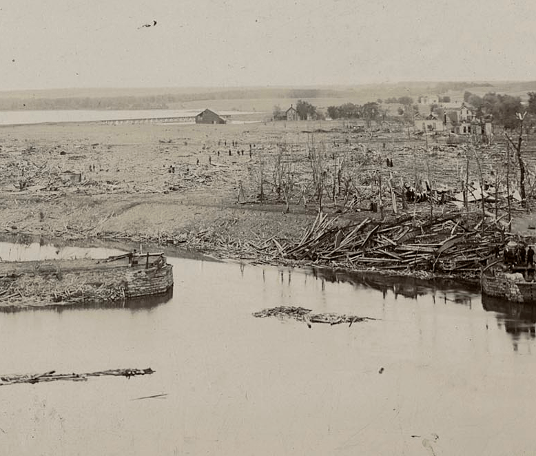
This was the site of the iron bridge across the Willow River that was destroyed. All that’s left of it is the pile of crumpled metal on the opposite riverbank on the right side of the photo.
Credit: University of Wisconsin
The brand new Nicollet Hotel, a three story brick building, was obliterated, reportedly even swept away. Five people died there. A nearby Methodist Church was also wiped out, its foundation swept clean. All that remained was the church bell that weighed about a ton and was thrown 200 feet. City Hall and the city’s bank were among the buildings destroyed and a 1.5 ton safe was thrown a full block. Parts of 1st Street were inundated when the town’s water tower collapsed. The iron bridge across the Willow River north of 1st Street was ripped from its moorings and dumped on the riverbank in a twisted heap as the tornado moved into the east side of town. The east side of New Richmond was primarily lower income housing. Roughly forty homes on either side of E 1st Street were annihilated.
It took the tornado just seven minutes to wipe New Richmond from the face of the earth. Out of the roughly 500 buildings in the town, only two dozen or so remained standing. Wisconsin’s beautiful “Garden City” was gone. 117 people died, 114 in New Richmond alone. It was one of the worst tornado disasters in US history and a day Wisconsin would never forget.
The devastation didn’t end with New Richmond. The tornado ravaged farmland for miles northeast of the city. It passed near Stanton and just north of Deer Park before leveling a farm near Clear Lake. Several rural homesteads near Richardson and Clayton were also destroyed, leaving some families homeless. The storm curved more east-northeast, apparently wiping out the village of Arland, where remarkably nobody was seriously hurt. It finally lifted southwest of Barron.
New Richmond stands as the eighth deadliest tornado in US history and is one of only 15 to cause more than 100 deaths. But today New Richmond is a thriving city of nearly 9,000 and growing, that terrible day in the last summer of the 19th Century mostly forgotten. It is commemorated only by a historical marker along Campus Drive nearly a mile south of the city center that it took Mother Nature just seven minutes to destroy.
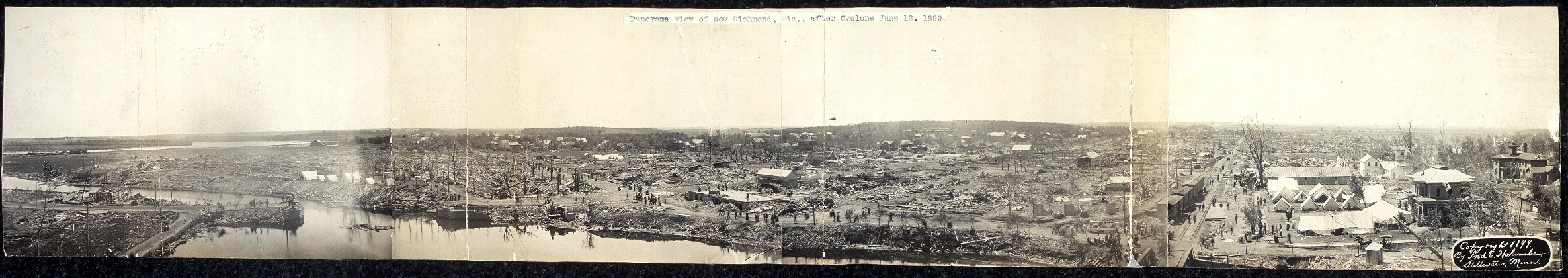
Panoramic view of New Richmond the day after the tornado.
Credit: Library of Congress
Snyder, Oklahoma – May 10, 1905
It had been a cloudy, blustery day in Snyder, Oklahoma, with the sky threatening rain most of the afternoon. By sunset, however, these threats had yet to come to fruition. Shortly before 8pm, residents reported hearing a terrible roaring sound coming from the southwest. Just a few minutes later, a severe thunderstorm moved over the town, bringing torrential rain and hail. The rain was brief but was followed by a spectacular electrical storm. One news reporter said that “electricity ran along the telephone wires with a hissing like a sky rocket starting on its upward flight.” This lasted another fifteen minutes or so before stopping as suddenly as it had started and an eerie quiet settled over Snyder. Few saw, or even heard, the half-mile wide F5 tornado that was about to devastate their town.
Two men survey the devastation in Snyder.
Credit: Oklahoman Archive
At 8:43 pm, the tornado slammed into Snyder. The town was virtually obliterated. Only a small cluster of homes on Snyder’s southeast side survived. The storm carved a path of devastation five to seven blocks wide from the western edge to the northeast corner. Survivors who managed to crawl out of the ruins wandered about in a daze as the screams of the injured filled the air. A heavy rain began to fall and in the pitch darkness, the survivors found themselves in an alien landscape. The entire west and north sides of town were wiped out. Some of the most extreme destruction was along the railroad tracks just north of 6th Street, where sturdy brick commercial buildings were leveled. A ten-stall brick roundhouse (basically a garage for train cars) was obliterated and two cotton gins weighing about as much as a small car were carried away.
Without any other means of communication, messengers were sent on foot to deliver news to the nearest town, Mountain Park just three miles to the north, and plead for assistance. Luckily, Mountain Park had a working telephone and, for 1905, help came quickly. Nearby towns hurriedly prepared relief trains and rushed to the aid of Snyder. They kept the trains coming all night, bringing doctors and strong hands with them. Daybreak revealed what had happened to Snyder. 97 people were dead and the town was gone. Where hundreds of buildings once stood, only ruins remained. It would be Oklahoma’s worst tornado disaster until the Woodward tornado of 1947.
Shabbona, Michigan – June 5, 1905
Less than a month after Snyder, this tornado reportedly devastated several farms across the thumb of Michigan. It touched down just south of the tiny farm village of Colling in Tuscola County and moved east-southeast. It passed very near the village of Elmwood, however the severity of the damage there is unclear. The tornado seems to have intensified after it moved into Sanilac County. Three farms were reportedly “wiped out of existence” just north and east of Shabbona. Large farmhouses disintegrated, the debris carried hundreds of yards downstream. Continuing southeastward, the tornado passed south of Deckerville and lifted northeast of McGregor. Five people died in the tornado and over forty were injured. This event remains somewhat mysterious. It was a lone cell with no other significant tornadoes being reported that day. Based on the position of the low pressure center, it seems likely that this tornado formed along or even ahead of a warm front, which is very unusual for a strong tornado. The same low pressure system spawned an F2 tornado near Binghampton, New York the following day. However these were the only two notable tornadoes from this system.
Pender, Nebraska – April 23, 1908
Overshadowed by the devastating Dixie Outbreak across the Deep South the following day, this tornado, produced by the same storm system, caused incredible damage to farms across western Thurston County, Nebraska. On April 23, a very deep low pressure system exploded over the Great Plains, igniting an outbreak of strong tornadoes. Earlier that afternoon, an F4 struck Deport, Texas, causing widespread destruction. This tornado was the only notable one to hit Nebraska that day. It touched down over extreme northern Cuming County and moved north-northeast over open farmland. Entire farms west of Pender were wiped out. Farmhouses were completely obliterated. The home of John Magnuson was reportedly lifted into the air and dashed to pieces. Magnuson’s mother and infant son were killed. The body of another child was found on a public road ten miles west of Bancroft, or about two miles south of where the tornado first touched down, without any clue as to where it might have come from. A “shower of shingles” as well as a photograph from the Pender farms rained down on Goodwin 35 miles to the north. The tornado continued northeastward, passing just a couple miles west of Thurston, lifting three miles north of the town.
The very next day, some of the worst tornadoes in US history ravaged the Deep South. A massive series of tornadoes from the same supercell devastated the towns of Amite, Louisiana and Purvis, Mississippi across an astonishing 155 mile path of destruction, killing 143 people. Earlier that day, another tornado family devastated vast swaths of rural Louisiana and Mississippi. 51 people were killed on plantations that were wiped out northeast of Natchez. Yet another violent tornado devastated Albertville, Alabama, killing 35. This outbreak is tied with the 2011 Super Outbreak as the fourth deadliest continuous outbreak in history.
Carleton, Nebraska – June 5, 1908

Damage to the Carleton school.
Credit: unknown
Just a month and a half after the Pender storm, an even worse tornado hit. This one devastated a large swath of south-central Nebraska. Hours earlier, a long track supercell thunderstorm had spawned a powerful tornado that caused severe damage to the town of Byron on the Kansas border. Three miles southeast of Deshler, that same supercell dropped another massive twister. This tornado caused widespread devastation all along its path as it moved due north. Several farms south of Carleton were wiped out. Some basically disappeared with so little remaining that it was difficult to tell a farm had ever existed there. The tornado wasn’t quite as strong when it hit Carleton itself, but five homes and two churches were completely destroyed while a new school building and some thirty homes were badly damaged. The tornado continued north-northeastward, ravaging farms along the way. Several homes were destroyed a few miles east of Shickley and four or five people were killed. The tornado devastated the Turner farm a mile west of Geneva. The home of John Shively vanished and the entire family of five was killed. The tornado lifted a few miles southwest of Fairmont. All told, at least eleven people were killed, dozens more were injured, and numerous homes were destroyed.
Creighton, Missouri – June 12, 1912
This tornado was one of a series of destructive tornadoes that struck Bates, Cass, Henry, and Johnson Counties in west-central Missouri, south of Kansas City, that day. The first tornado formed across the border in Kansas near the town of La Cygne and moved north-northeastward. It did major damage in the vicinity of Merwin, Missouri, flattening homes on either side of the state line. Passing a few miles east of Drexel, the tornado destroyed twelve homes in the Prairie View Church area (this community no longer seems to exist). One large brick home was entirely obliterated, the debris scattered across a two-acre area. Miraculously, none of the seven people inside were seriously hurt. This tornado did, however, kill at least eleven people (some estimates go as high as 22). The tornado lifted five miles northeast of Drexel.
Despite the wealth of information on the first tornado, the main F5 tornado remains somewhat mysterious. Sources differ, but it’s believed to have formed over rural areas southeast of Amsterdam and moved northeast. It caused devastating damage near the town of Adrian. The Bates County Record gave a vivid account of the destruction: “Where once homes, barns, haysheds and granaries stood, nothing was left but heaps of ruins. In one space not more than one-fourth of a mile wide, there were 150 dead animals… Hogs were found dead, with timbers driven through their bodies… A large draft stallion was picked up by the wind and carried 250 yards from the barn and on another farm, a horse was blown from the barn and later found dead one-fourth of a mile away. Wheat straws were driven into pine boards an inch in thickness. In several places along the track of the storm, corrugated iron roofing was wrapped completely around telephone poles, and on one farm a burr oak plank was planted upright in the ground so firmly that it was impossible for a strong man to loosen it.” Fortunately only three people were killed in the Adrian area.
Continuing northeast, the tornado reportedly caused even more impressive damage near the town of Creighton in Cass County, though damage was not as widespread. Several homes were destroyed, including two that were entirely obliterated. Four people were killed in the Creighton area. After that, the details are murky. Modern research has suggested that the second tornado lifted and a third one formed, going on to cause heavy damage near the town of Leeton in Johnson County, however this may have been a continuation of the second tornado.
Mullinville, Kansas – June 11, 1915

The tornado moving through farmland north of town. This is the earliest known photograph of an F5 tornado.
Credit: NOAA
This tornado struck near the town of Mullinville, just seven miles west of Greensburg. It formed over open country southwest of town and moved slowly northeastward. One farm on the edge of town was utterly obliterated and many homes were destroyed. Three mules were reportedly carried a full two miles. As the tornado moved northeast, as many as eight separate funnels were observed under the huge rotating cloud. It isn’t apparent from the photo, but at one point this tornado was a mile wide. Luckily for those in its path, the tornado struck in broad daylight and the funnel was visible for miles. No one was killed and few, if any, were injured. Damage totaled $75,000, equivalent to $1.7 million in 2011. A photograph of the tornado was published in the Monthly Weather Review in July, 1919. It is the oldest known photograph of an F5 tornado.
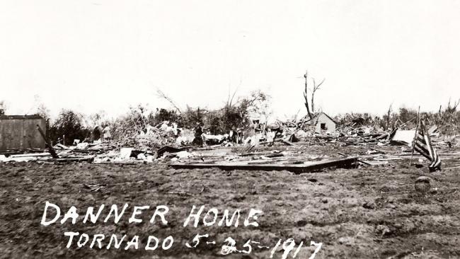
Sedgwick, Kansas – May 25, 1917
This monstrous tornado left a trail of devastation across rural Sedgwick and Harvey Counties. It touched down a few miles northwest of Cheney near the Kingman County line and tracked almost due northeast for 65 miles. Dozens of farms in Sedgwick County were completely swept away. At the time, this part of south-central Kansas was considered one of the richest and finest farming districts in the state. Numerous large farm buildings were completely wiped out. It was a monster three-quarters of a mile wide when it slammed into the town of Andale. Twelve people were killed and half the town was destroyed.
A home reduced to its slab near Sedgwick.
Credit: Harvey County Historical Society
Continuing northeast, it crossed the Arkansas River just south of Bentley, where it devastated the John Hohman farm. The tornado whipped across the prairie at up to 65 mph. Those in its path had little time to react. As it moved northeast, it continued to grow in size and was becoming wrapped in rain. Soon, it was a mile and a quarter wide F5 bearing down on Sedgwick. The tornado caused incredible devastation south and east of town. Several farms and a schoolhouse south of Sedgwick were obliterated. The devastation continued as the tornado moved into Harvey County. Numerous homes just east of Sedgwick were completely destroyed. The home of Will Norris was wiped from the face of the earth. According to the Evening Kansan-Republican, “There is not a wheel barrow load of lumber left. Even the foundation is level with the ground. The entire house was carried away so that not a vestige of it remains in sight even across the wheat field lying in the path of the storm.” Unfortunately, Norris was home at the time and did not survive. His crushed body was found in a nearby field. Eight people were killed in the Sedgwick area.
The Fife farm five miles south of Newton was decimated. Numerous large farm buildings were completely destroyed. The farmhouse, described as “one of the finest country homes in the county,” was obliterated. Mrs. Fife was blown into the front fence but miraculously survived. Mr. Fife, his son and a farmhand took shelter in a small shed away from the path of the tornado. When they emerged, they saw that most of their farm had been destroyed. A large water tank was nowhere to be found, carried away by the tornado. The tornado caused heavy damage near the tiny farm village of McLain. The Breitenstein farm was largely destroyed, but luckily no one was killed. However, two people were killed elsewhere in the McLain area. When the tornado passed through the northwest corner of Butler County, one person was killed near the town of Elbing. However, as it moved into Marion County, it finally began to weaken. It passed southeast of Peabody before lifting just north of Florence.
The tornado killed a total of 23 people and 118 farms, homes, and businesses were wiped out. This was just the beginning of a devastating series of outbreaks that ravaged the country over the next few days. The following day, a massive F4 tornado devastated the Illinois towns of Mattoon and Charleston, killing 101, making it one of only 14 tornadoes to kill more than 100 people in the United States. The day after that, another F4 ravaged rural communities in southwest Kentucky, killing 67. It was the deadliest tornado outbreak since 1896.
Carroll, Iowa – May 21, 1918
This tornado devastated numerous farms across parts of Crawford, Carroll and Greene Counties. It was part of a prolonged, widespread outbreak across the Great Plains that began on May 18. The tornado touched down about five miles east of Denison and moved east-northeast. Carroll County was hardest hit. Passing south of Arcadia, entire farms were obliterated. Large farmhouses were wiped out of existence, their foundations swept clean. The same scene played out just a few miles northwest of Carroll. Large farms in the Maple River area were completely wiped out. Mattresses and pieces of homes were found two miles away. Continuing east-northeastward north of Carroll, the tornado passed very near the town of Lidderdale. Moving into Greene County, the tornado began to weaken and lifted near the village of Adaza, northwest of Churdan. Near the end of the track, a couple were caught out in the open racing home in a buggy and killed when the buggy was thrown into an adjacent field. Amazingly, just four people died throughout the track and thirty were injured. The other two deaths were in a home that was leveled near Lidderdale.
At around the same time, another powerful tornado struck city of Boone fifty miles east of Carroll. The southeast section of the city was devastated and large, steel-frame industrial buildings were leveled. Several homes were swept away as well. This tornado was concurrent with the Carroll tornado for a portion of its track and may have also been an F5. Entire farms northeast of Boone reportedly vanished. The track of the Boone tornado was very near that of both the Grinnell tornado to the south and the 1976 Jordan tornado just a few miles to the east.
Fergus Falls, Minnesota – June 22, 1919
The wreckage of the Grand Hotel in Fergus Falls. 35 people died here.
Credit: gendisasters.com
It was the first day of summer in Fergus Falls, Minnesota, then a quiet North Country town of 12,000, and it sure felt like it. It was hot and humid, with a daytime high of 88F. The afternoon’s events would change the town forever. At around 3pm, thunder could be heard in the distance. In Fergus Falls, however, it was eerily still – not a breath of wind. “Even the dogs stopped barking,” said one survivor. The sky began to grow dark, the clouds churning ominously.
The tornado touched down at around 4:15pm a few miles northwest of Fergus Falls and moved southeast. At 4:30, a torrential downpour began to fall. A couple miles northwest of town, a passenger train headed for Fargo was approaching the Pelican River Bridge. The passengers saw a waterspout spin up on the river. Then, all of a sudden, it grew very dark inside the train and out of nowhere the main tornado slammed into the baggage car. Seven of the eleven coaches were thrown from the tracks. The baggage car was torn loose and carried thirty feet away and the section of track underneath the car was torn from the ground. Fortunately, nobody on the train was seriously injured.
Meanwhile in Fergus Falls, it was pitch dark, the rain still pouring down. Loud, continuous thunder roared overhead with numerous cloud flashes. Large hail up to the size of baseballs began to fall. At 4:46pm, the tornado slammed into the north side of the city. It tore down Union Avenue, decimating entire neighborhoods on the west side of Lake Alice. Swerving to the southeast, the tornado ripped through the downtown business district before weakening and moving out of the city, lifting just a couple of miles southeast of town. The northern half of Fergus Falls was “a vast acreage of kindling.” Forty-four city blocks, including the business district, were leveled. Lake Alice was choked with debris. Large houses were completely swept away. Trees were stripped of bark. Wreckage was carried a full ten miles. A blank check from Fergus Falls was found sixty miles away. The Grand Hotel, a three story, 100-room hotel, was completely destroyed, killing 35 people inside. The Otter Tail County Courthouse and the county jail were also wrecked. In all, 57 people were killed, over 200 more were injured, and 400 buildings were destroyed. It was Minnesota’s worst tornado disaster of the 20th century.

A view of the devastation at the intersection of Union Avenue and Vine Street.
Waco, Alabama – April 20, 1920
This massive tornado or family of tornadoes left a 130-mile trail of devastation across northern Mississippi and Alabama. It first touched down near the town of Bradley, Mississippi southwest of Starkville and moved northeast. The tornado caused widespread devastation throughout its path. Seven people died northwest of Starkville, where dozens of homes were leveled. The small town of Cedar Bluff eight miles west of West Point was hit particularly hard. Ten people were killed in that community alone. The worst was yet to come however. Moving into Monroe County, the tornado intensified. It ripped through the west side of Aberdeen as an F4 up to half a mile wide. 22 people died and a large portion of the town was destroyed. Five others died elsewhere in Monroe County.
Moving into rural areas, the tornado crossed the border into Alabama near the Itawamba County (MS) line. It would cause incredible devastation across Marion and Franklin Counties. Passing south of the town of Bexar, the tornado was over a mile wide. Rural areas north and west of Hamilton were laid to waste. Dozens of homes were completely destroyed. Shingles were driven into oak trees. At one farm, a Ford car was thrown a quarter of a mile over a field. Twenty people died in Marion County, nine south of Bexar and another eleven north of Hamilton.
The tornado passed between Hodges and Hackleburg and crossed into Franklin County. It struck the Spruce Pine area north of Phil Campbell and several homes were leveled. The tornado, however, intensified as it bore down on the Russellville area. Waco, Alabama was a tiny industrial village near a state-owned quarry about six miles east southeast of Russellville. The tornado of April 20, 1920 slammed into it as a mile-wide F5. Waco was wiped from the face of the earth. Not a vestige of the village remained. The ruins of Waco fell from the sky as much as twelve miles away. Parts of houses, half of the village’s garage and other debris were picked up off the streets of Russellville. “Half of an immense bowlder (sic)” as well as doors and window frames were found in the town of Littleville eight miles northwest of Waco in Colbert County. “A carload of stone was whipped about like a feather, and trees…were twisted from the roots as if they had been bits of wire.” People in Russellville and Littleville and even as far away as the Wilson Dam near Florence reported feeling tremors just prior to the storm. Nineteen people were killed in Franklin County, most of them in and around Waco. The tiny hamlet was rebuilt, but it never recovered. Today, all that remains of Waco is the Baptist church and a handful of homes.
Continuing northeast, the tornado passed along the Colbert County line and into Lawrence County, where it struck the Town Creek area as a weaker tornado before finally lifting a short time later. It is unknown if this was a single tornado or a family of tornadoes produced by the same supercell, but a total of 88 people were killed across Mississippi and Alabama and hundreds of homes were completely destroyed. It was one of the most devastating tornadoes in Alabama’s history. This was not the only powerful tornado to ravage Alabama that day. A high-end F4 devastated the town of Arley, completely destroying numerous homes, some of which were wiped from the face of the earth. 21 people were killed. Another F4 tore through Meridian, Mississippi, killing 36 and a third struck Lilly Flag southeast of Huntsville, killing 27. Two more violent tornadoes in Mississippi killed a combined 51. It was one of Dixie’s most devastating outbreaks.
Alameda, Saskatchewan – July 22, 1920
Canada’s first recorded F5 tornado, this one devastated farm country across southeastern Saskatchewan. The details of this event are somewhat murky, including its exact track. According to newspaper accounts, damage was first noted near the town of Yellow Grass sixty miles northwest of Alameda and continued to the southeast. Significant damage was reported near the town of Lampman, where three people were killed and twenty were injured. Passing north and east of Steelman, the tornado seems to have turned more to the east. It was at this point that the tornado was most destructive. Entire farms north of Frobisher and in the Alameda area were completely destroyed. “Splendid homes” were obliterated. The home of Guy Holmes was wiped from the face of the earth, the debris scattered for miles. Not a vestige of the house remained. Holmes, his wife, newborn child and a wet nurse were all killed. The home of one R. Long was also obliterated, the furniture nowhere to be found. Fortunately, no one was home at the time. The tornado lifted four miles east of Alameda.
Pinson, Tennessee – March 11, 1923
The powerful low pressure system (with a minimum pressure of 972 millibars, equivalent to a strong Category 2 hurricane) that moved through the country in the early part of March, 1923 is probably more notable for the blizzard that it brought than its tornadoes. A heavy, wet snow and whipping tropical storm force winds caused widespread power outages across Iowa and northern Illinois. Parts of northern Illinois were also hit with a crippling ice storm. In the town of Oregon, southwest of Rockford, ice on powerlines was reportedly 3-4 inches thick. This was along with up to a foot of snow and high winds. At the same time, a line of severe thunderstorms moved through southern Illinois that evening with at least one notable tornado. However the worst devastation would come farther south in western Tennessee.
Pinson, Tennessee was, at the time, a small community of 500 five miles northwest of Henderson in Madison County. The tornado that devastated it that day came virtually out of nowhere. It touched down in the middle of the night just southwest of Deanburg in Chester County and moved northeast, strengthening very rapidly. The narrow but powerful tornado caused heavy damage in Deanburg, where two people were killed, and it continued to intensify as it bore down on Pinson. It swept through the town without warning. The result was devastating. At least sixty homes (roughly half the town), along with a school and two churches, were obliterated. That entire section of town was reportedly wiped out of existence. A freight train idling on a side track in Pinson was thrown from the tracks. Fortunately none of the crew was seriously injured. The same could not be said for the people of Pinson. Most of them were asleep, and the area had been pounded by severe storms all night. The roar of the tornado was swallowed by the sound of the wind and rain. They never knew what hit them.
Newspaper accounts make special mention of a teenage boy who, after impassible roads forced him to abandon his horse just two miles out, trekked six miles on foot, in pitch darkness through mud and driving rain, to the nearby city of Jackson to deliver news of the disaster and plead for help. His heroism likely brought aide to the stricken town hours before it would’ve otherwise come. Eighteen people died in Pinson, and another seventy were injured. Human remains were found up to a mile away. It was Tennessee’s only F5 until 1998.
Colorado City, Texas – May 14, 1923
This massive tornado caused incredible devastation across rural Howard and Mitchell Counties. It touched down five miles southeast of Big Spring in the pre-dawn hours of May 14 and moved east-northeastward. The 1.5 mile wide monster swept through farm country south of present-day I-20. Entire farms simply vanished. Some fifty homes, including one of the largest ranch houses in the county, were wiped from the face of the earth. Heavy machinery were thrown about like toys. Bodies were carried up to half a mile. Explicit details of the devastation are somewhat sparse, but by all accounts, the damage was incredible. Passing a few miles south and east of Colorado City, where the large ranch home vanished, the tornado moved between there and Loraine, passing very near the latter. The tornado lifted four miles northeast of Loraine. Twenty three people were killed and another 250 were injured.
Thorp, Wisconsin – September 21, 1924

Damage to the Oberley residence near Reseburg. Note the chunk of the foundation that appears to be missing in the back of the picture.
Credit: Thorp Area Historical Society
Thirty years to the day after the Plum Creek F5, this tornado left a trail of devastation across Clark and Taylor Counties in Wisconsin. It touched down about two miles southeast of Augusta in Eau Claire County and moved northeast. It initially passed over very sparsely populated areas for some fifteen miles of Eau Claire and Clark Counties. When it finally reached populated areas, it was incredibly powerful and destructive. Several farms near Reseburg four miles south southeast of Thorp were almost entirely destroyed. The Oberley farm was decimated. The farmhouse was lifted into the air and dashed to pieces, the debris deposited in a creek some fifty yards away. The site was nearly swept clean. The family took shelter in the basement and was unhurt. In a photo of what was left of their home, it appears as though a piece of the basement’s concrete retaining wall is missing, an incredible display of force. Also, heavy machinery on the farm was thrown great distances. The entire wall of a farm house was reportedly carried 14 miles.
The Graikowski farm four miles east of Thorp was virtually obliterated. Nothing was left standing, not even a tree. The Graikowskis’ fifteen year old daughter was killed and everyone else was seriously injured. Across the street, the Tom Hedler home was also obliterated. Hedler, who was asleep, was thrown from the house into a large water tank nearby. Luckily, he suffered only a broken wrist. Passing north of Withee, the tornado crossed the Black River near the village of Clark, tearing a steel railroad bridge from its piers and dropping it into the river. The Schmitfranz family was driving down a nearby road when the husband stopped and got out to view the storm. Suddenly it changed direction and headed right for them. Before the husband could return to the car, the tornado picked it up and hurled it 100-200 yards over a field. Their three year old daughter was killed but the wife miraculously survived, though severely injured.
The tornado then crossed into Taylor County and moved into more rural areas. Reports of damage in Taylor County are conflicting, but the tornado seems to have been somewhat less powerful. Reports of twelve people killed near a village called “Redville” seem apocryphal. The tornado finally lifted two miles north of Chelsea. At least 18 people were killed, 14 in Clark County and four in Taylor County, and dozens of homes were destroyed.
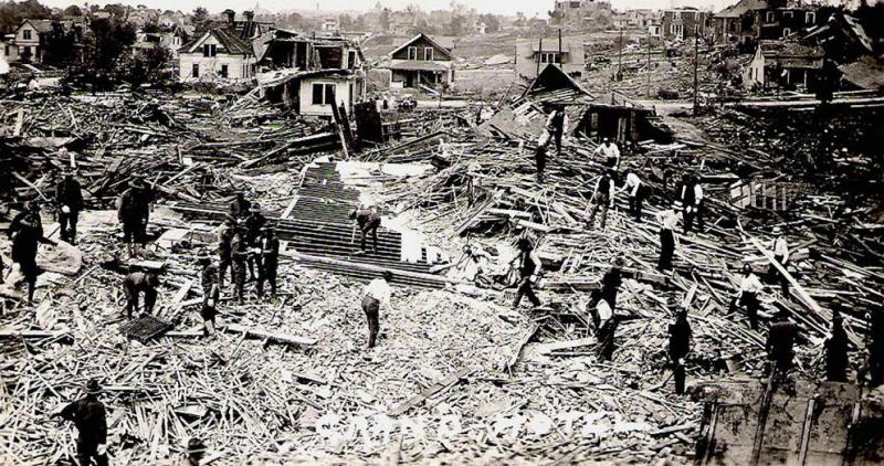
Murphysboro, Illinois – March 18, 1925
Meteorology in the early 20th century was a maverick science. It was often pursued by those who weren’t too concerned with their reputation. Tornadoes in particular were considered unpredictable and attempting to understand them was viewed as a fool’s errand. Even the word “tornado” was taboo in academia at the time. March 18, 1925 changed everything. Scientists and researchers have spent the nine decades since trying to understand exactly what happened that fateful Wednesday afternoon. Every aspect of the Tri State Tornado defies belief and flies in the face of modern tornado science. Yet after decades of intense scrutiny, the scale of history’s greatest tornado cataclysm has only grown, as has its legend.
It was a gloomy spring day in the Midwest, with temperatures in the mid to upper sixties but a steady, dreary rain. One of the many strange facets of this event was the fact that the tornado’s path was almost entirely coincident with the passage of the surface low pressure system that created it. This is highly unusual for a strong tornado because the most favorable conditions are typically in the warm sector well ahead of the cold front. The tornado touched down three miles northwest of Ellington, Missouri shortly after 1pm and moved rapidly northeast at roughly 60 mph. It slammed into the town of Annapolis without warning. The town was virtually obliterated. Amazingly, just four people were killed. A total of eleven people were killed in Missouri. The tornado continued to grow and intensify as it moved through rural Missouri. By the time it reached the Mississippi River, it was at least a mile wide.
The skies over Gorham, Illinois suddenly became pitch black and a roaring could be heard in the distance. Clouds of debris filled the air…then everything exploded. When the survivors emerged from the rubble, they saw nothing but ruins. 34 people were dead and Gorham had been annihilated. Not a single wall remained standing in the small town of 500 along the banks of the Mississippi. Watches and clocks pulled from the wreckage revealed a moment frozen in time. It was 2:35pm.
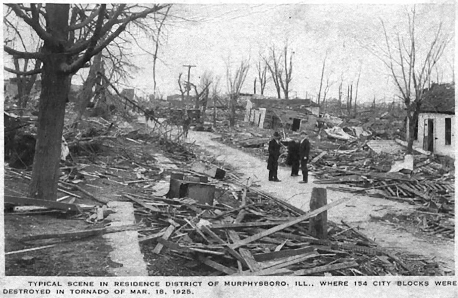
The devastation in the residential section of Murphysboro.
Credit: Jackson County Historical Society
The town of Murphysboro was a railroad hub built on industry, from farming to mining. At the time, it was home to nearly 12,000 people. The scale of the catastrophe that was about to befall them is simply unimaginable. Few in the town ever saw the tornado coming. It was so massive that it just looked like a low cloud rolling across the ground. Then the sky went black as the mile-wide monster slammed into the town. 154 city blocks were obliterated. Most of Murphysboro’s residential section was in ruins. Before rescuers could reach the injured, the ruins were swept by fire. Many who survived the tornado died in the flames with rescuers standing by powerless. The smoke from the fires billowed into the sky and could be seen for miles around. The Longfellow School, where over 100 students were in class, was hit and the roof collapsed down on top of the terrified occupants. Seventeen students were killed. 234 people died in Murphysboro and 623 were injured. It was one of the highest death tolls ever suffered by a single town from a tornado, second only to the 243 that died in Gainesville, Georgia in the 1936 tornado. Like Galveston after the 1900 hurricane, Murphysboro never really recovered. Major businesses moved elsewhere and then the Great Depression hit. The town wasn’t even fully rebuilt until World War II. For nearly twenty years, numerous vacant lots just sat there empty, a grim reminder of that terrible day. Before the tornado, Murphysboro was home to nearly 12,000 people. At the 2010 census, the population was less than 8,000.
Severe ground scouring near Desoto. There were once homes here.
After leaving Murphysboro, the tornado ripped through the nearby town of Desoto. An entire section of town simply vanished. Rows of houses were swept so clean that it was impossible to tell that any man-made structures had ever existed there. It was just a field with a dirt path down the middle. 69 people died here, 33 of those were students and teachers at the local school. It was one of the worst school disasters in US history. Passing by the towns of Hurst and Bush, the tornado moved into Franklin County, where it wiped out a mining village on the northwest side of West Frankfort. After the power to the lift was cut, the miners were forced to climb the 500 feet to the surface. When they got there, they saw utter devastation. 500 of the miners’ homes were completely destroyed. Many of them lost their entire families and all their worldly possessions. At least 127 people were killed, many of them women and children.
Continuing northeast, the tornado began to move over more rural areas. The village of Parrish, two miles southeast of Logan-Hanaford, was wiped from the face of the earth. Just two homes remained standing. 22 people were killed there and reportedly only three residents escaped injury. The tornado’s passage over rural areas did not bring an end to the slaughter. 65 people are believed to have died in the open country between Parrish and the Wabash River, 25 of those in rural schools.
The destruction in Griffin, Indiana after the tornado.
Crossing the river into Indiana, the tornado turned more north-northeastward and reintensified. By now, the tornado was reportedly whipping across the landscape at 73 mph, the fastest forward speed ever recorded for a tornado. The residents of Griffin never saw it coming. At shortly after 5pm eastern time (4pm in Murphysboro), the tornado slammed into Griffin as a three-quarter mile wide F5. The town was all but obliterated. 26 people were killed, a possibly merciful total. The tornado continued north-northeastward unabated toward the larger town of Princeton. It tore through Princeton’s northwest side at around 5:30pm. A quarter of the town was destroyed and 45 people were killed. By the time the tornado reached the village of Wheeling, it was at last beginning to weaken. Then, at roughly 5:40pm a few miles southwest of Petersburg, it finally, mercifully, retreated back into the clouds.
The tornado had traveled an unbelievable 219 miles across three states, leaving incredible devastation in its wake. It killed 695 people, more than twice as many as any other tornado in US history, injured at least 2,027, destroyed over 15,000 homes, and wiped four towns from the face of the earth. It’s believed to have been on the ground for roughly three and a half hours. In the ensuing decades, researchers have picked apart this event trying to find breaks in the track. Surely one tornado can’t be continuous for 219 miles. Most long-track tornadoes, especially pre-1980, were actually what are called a “tornado family,” that is a series of tornadoes produced by one storm cell in quick succession. A study in 2013 found possible breaks near the beginning of the track after the destruction of Annapolis. However the tornado was found to have likely been continuous for at least 174 miles from Madison County, Missouri (when the tornado was south of Cherokee Pass) to Pike County, Indiana (the tornado’s end point). The 151 mile section from north of Sedgewickville, Missouri to SW of Petersburg, Indiana was almost certainly one tornado. The longest continuous tornado track verified by modern science was the 149.25 miles traveled by the Yazoo City, Mississippi tornado on April 24, 2010.
The Tri State Tornado changed the way Americans looked at tornadoes. It inspired private citizens to create the first storm spotter networks, and the Weather Bureau finally began to make a concerted effort to try and understand tornadoes. Real progress, however, wasn’t realized until the advent of radar during World War II.
Yorkshire, Iowa – June 3, 1925
This tornado is shrouded in mystery. It’s believed to have touched down two miles north of Neola in Pottawattamie County and moved due north to a point two miles west of Persia in Harrison County, crossing mostly rural farmland. A couple of farms near the tiny farm village of Yorkshire were flattened and a couple of farm houses were completely swept away. Fortunately, just one person was killed. Another 30 were injured. A number of questions have swirled around this event. It has been suggested that there were actually two tornadoes that hit roughly the same area in quick succession. Therefore, the damage may have been so extreme because the same buildings were hit by both tornadoes. Several lists have shown two F4 tornadoes following virtually the same path rather than a single F5 tornado. Personally, I think this is unlikely. Apocryphal claims of multiple storms hitting the same spot in quick succession are not uncommon in the press of the period, especially for major events. It’s also possible that this was a double tornado in which a tornado splits into two funnels. This is simply a type of multi-vortex tornado and is still technically a single tornado.
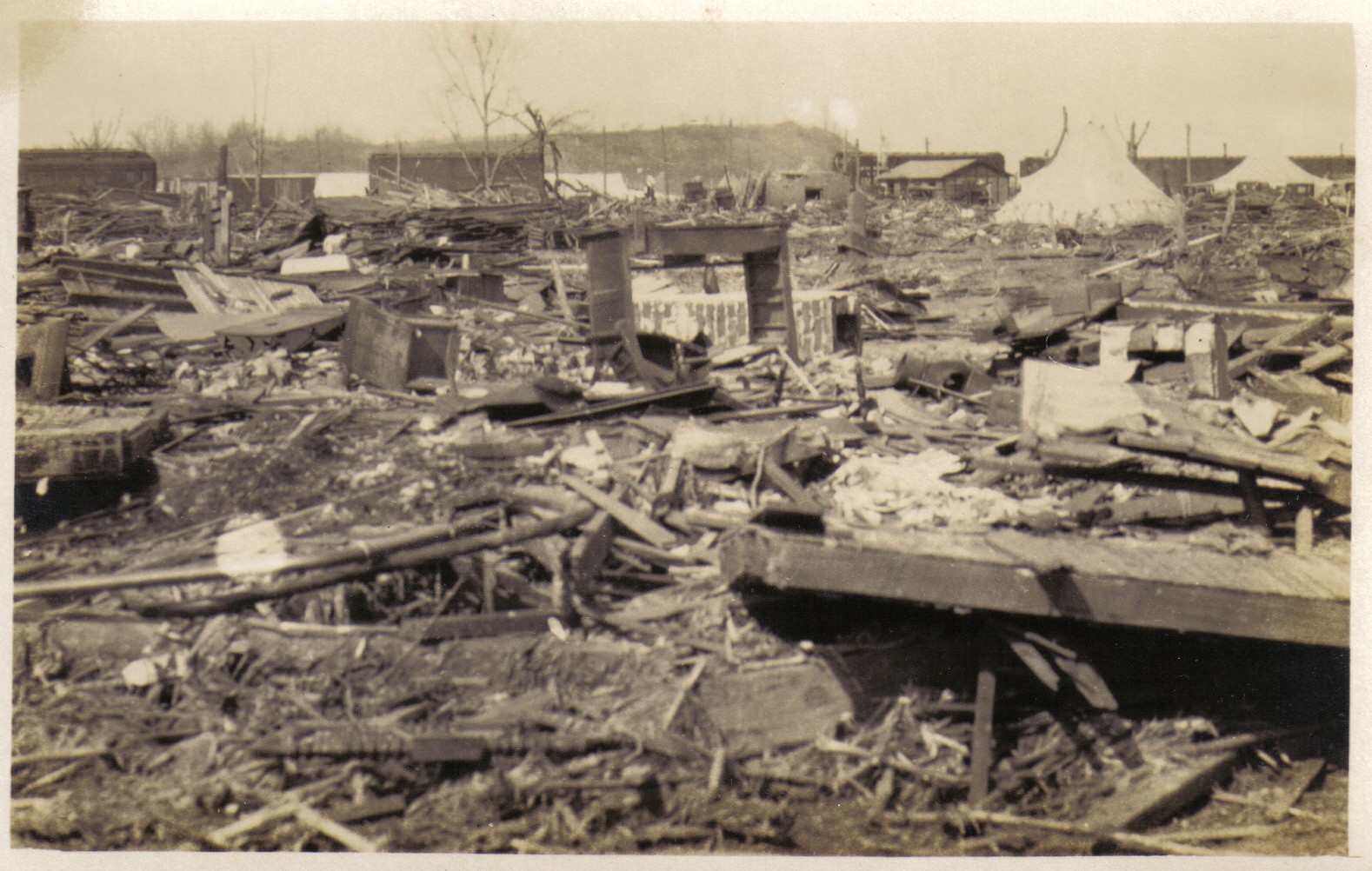
Rocksprings, Texas – April 12, 1927
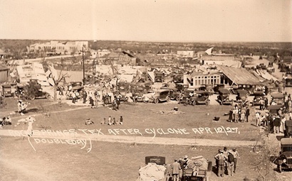
Rocksprings after the tornado.
Credit: Texas Escapes/Barrows family
The town of Rocksprings lies in the middle of nowhere in southwest Texas about 100 miles west southwest of Austin. It sits on a high, rolling plateau at 2,450 feet of elevation surrounded by rocky hills. This part of Texas rarely sees tornadoes. No tornado stronger than F1 has touched down anywhere near this area in the past sixty years. That makes the events of April 12, 1927 all the more remarkable. It had been unusually hot that day. Thunder could be heard throughout the afternoon. Residents were hopeful that a spring shower would come and cool them off, but by sundown no rain had fallen. However, as the sun went down at about 7:30pm, a steady southeast breeze suddenly dropped to a dead calm and an ominous cloud with an eerie red glow appeared on the horizon. Hail the size of baseballs followed.
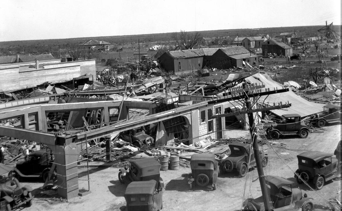
Large commercial buildings in Rocksprings were leveled.
Credit: Kerrville Daily Times
The tornado came from the northwest. It was a monster F5 a mile wide. Witnesses as much as 60 miles away reported seeing a massive dark cloud, glowing red, dip to the earth near Rocksprings followed by an audible roar. The tornado swept over the town at 7:50pm. Rocksprings was obliterated. Large sections of town simply vanished. Out of the town’s 247 homes and businesses, just 12 remained standing, six of them habitable. Some homes simply disappeared, their foundations swept bare, the ruins nowhere to be found. Large commercial buildings made of concrete and stone were leveled. The town was so remote that it was five hours before relief workers arrived. A local telephone operator who was injured in the tornado took a portable phone unit to a section of undamaged wire on the outskirts of town to phone for help.
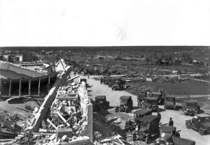
The ruins of the large hotel, built of stone and mortar. Notice the surrounding area is empty. There were once buildings there but they were destroyed in the tornado. The rubble had been removed by the time this picture was taken. Note the shredded and debarked trees in the background.
Credit: Kerrville Daily Times
An eyewitness (possibly the same telephone operator) saw a house hurled through the air across W Main Street into a two-story brick school building. He raced back inside his home moments before it too was leveled. Luckily neither he nor any of his family members were seriously injured. When he emerged from the ruins, he saw that every building along Main Street had been wiped out. He and numerous other survivors grabbed crowbars, axes…any tools they could find…and frantically dug through the rubble looking for people trapped, clutching candles or lighting oil-soaked rags to see through the darkness. The first people they found were the bodies of two little girls with their arms wrapped around each other. The bodies of the parents were found nearby. There were so many cries for help and not enough uninjured men to help them. As the hours passed, the cries gradually faded. These are the terrible human stories that are often lost to history. Fire swept the ruins in the wake of the tornado and hampered rescue efforts. Undoubtedly many survivors trapped in the ruins waiting for rescue died in the flames.
This was one of the first tornadoes where aircraft were used to study the damage path from the air. This marked a considerable advancement in tornado science as meteorologists were able to make detailed observations about the character of the debris field. From the air, the extreme power of the tornado was obvious. Large sections of town were not just obliterated, they were almost completely free of debris. Some of the larger buildings still standing had debris piled around them. As of the 90th anniversary in 2017, debris from the tornado can still be found on the surrounding prairie. The tornado was found to have lifted five miles southeast of town. The same cell dropped at least two more tornadoes farther to the southeast near Leakey and Utopia.
74 people were killed in the tornado, all but two of them in Rocksprings, and 200 more were injured, roughly a third of the town’s population. It was one of the worst tornadoes in Texas history. The tornado was gone in just a few minutes, followed by a heavy electrical storm, and finally, as if in mockery, a soft rain fell on the ruins of Rocksprings.
Medicine Lodge, Kansas – May 7, 1927
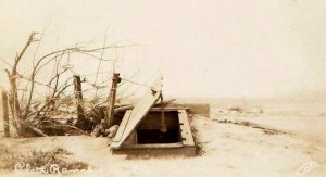
This is the storm cellar that sheltered the Platt family. It appears to be partially caved in on the left. The remnants of the vanished farm is behind it. A galvanized iron ventilator was apparently sucked out of the cellar and carried away.
Credit: Teresa Chapman
This massive tornado left a trail of destruction nearly 100 miles long across four counties in south central Kansas. It touched down over open country in extreme southeastern Comanche County about five miles southwest of Aetna and moved northeast. Near the county line northwest of Aetna, members of the Platt family watched as the large, stovepipe tornado snaked its way across the plains towards them. The took shelter in a storm cellar right before the tornado swept right over them.
When they emerged from the cellar, their entire farm, consisting of a huge barn, two large houses, and numerous sheds, had vanished, leaving empty foundations. The tornado was so powerful that a galvanized iron ventilator was sucked out of the storm cellar as it passed. Some 300 lb cement slabs used to anchor the porch of one of the homes were carried fifty feet and strips of iron and steel were found wrapped around what was left of the trees. All around the property were groves of tall cottonwood trees, “great forests of them.” They too were gone, ripped out of the ground and thrown or shredded down to the stump. A car was thrown a great distance across the property and obliterated. Debris was scattered for miles across the surrounding prairie. Other pieces of heavy machinery, including a tractor, were also ripped to pieces and blown hundreds of yards. The large wheel of a combine harvester from the Platt farm was found several miles away. Another was thrown about 40 yards and embedded in a tree. So little was left that they found themselves disoriented, unable to tell where they were. Nearby, the Wells family home was also obliterated. And this was just the beginning.

Amidst the broken tree branches is the obliterated remnants of a car on Platt Ranch near the beginning of the track, likely thrown a considerable distance.
Credit: Teresa Chapman
The tornado moved northeast into Barber County. It was here that arguably the most incredible damage occurred. Several farms across rural Barber County were utterly obliterated. At the farm of one U.L Thompson about fifteen miles southwest of Medicine Lodge, all the ranch buildings were annihilated, the debris scattered across the surrounding fields. The tornado was so powerful that it tore large chunks of topsoil out of the ground, leaving holes up to a foot in depth. To the northeast, a church called Union Chapel was wiped from the face of the earth. Not a single plank remained. A piece of the foundation was even torn loose. Union Chapel was rebuilt and still stands, in the middle of nowhere eight miles west of Gerlane. Jogging briefly to the north, three more farms were wiped out and a rural school vanished.
At another farm, also obliterated, a five ton tractor was rolled some 500 feet. At the Lytle farm nearby, the front wheels of a tractor were ripped from the chassis and carried away. A large threshing machine, weighing about as much as a small car, was nowhere to be found. Numerous other pieces of farm machinery were carried long distances across the damage path. A brand new Pontiac landau was ripped to pieces, the wreckage scattered across nearby fields. Pieces of the car were reportedly found miles away. The bodies of livestock were carried up to two miles. All along the way, farmhouse after farmhouse was wiped out of existence, swept clean to the foundation. The entire section south and west of Medicine Lodge was simply annihilated. Not even the vegetation survived. The grass along the damage path in southwestern Barber County was said to have had the appearance of being burnt. Wheat was pulled from fields, and debris was scattered for miles. Large timbers and pieces of iron were found embedded in the ground so deep that they couldn’t be removed by hand.
People in Medicine Lodge watched in horror as the massive funnel churned through farmland to the south. Many of them took shelter, fearing it would hit the town. Luckily, it did not. However, just south and east of town, the devastation continued. Three miles south of Medicine Lodge, a big steel bridge across the Medicine River was torn loose and carried 100 yards down river. Several nearby homes and a rural school were obliterated and three people were killed. 175 idling boxcars along the railroad 2.5 miles southeast of town awaiting the harvest were thrown from the tracks. 75 were obliterated and several were rolled a quarter of a mile. About two miles east of Medicine Lodge, yet another home was wiped out and a teenage girl and infant child were thrown a quarter of a mile but miraculously survived. At a nearby farm a large, concrete silo was leveled and smashed to pieces and the rung of a chair was driven through a refrigerator. After destroying several more homes northeast of Medicine Lodge, the tornado moved into Kingman County.
Despite the wealth of information on the damage in Barber County, not much is written about what happened after that. The tornado moved over more sparsely populated areas in Kingman County, but continued to cause major damage. The tornado, however, was notably weaker in Kingman County than it was in Barber County. One person was killed near Nashville and another was killed two miles west of Kingman as the tornado moved northeast. It reintensified after it moved into Reno County. Now the mile-wide monster was headed straight for the city of Hutchinson. The tornado tore through the east side of town, demolishing numerous homes and a few large industrial buildings. The boiler room at the Carey Salt Plant collapsed, killing one worker and injuring numerous others. However, as with the rest of the tornado track, the death toll was miraculously low. Hutchinson suffered $750,000 worth of damage, equivalent to nearly $10 million in 2011.
The devastation continued to the north and east of the city. Several farms near Medora were devastated. The body of a six-month old baby was found a full mile from its obliterated home. A farmer was also killed before the tornado moved into McPherson County. Two more people were killed on a farm just across the county line before the tornado finally began to weaken. It lifted near the town of Inman. The tornado had left a trail of devastation 95 miles long and at least a mile wide in most places. Miraculously, only ten people were killed throughout the tornado track. The tornado was visible for miles and most people, some by sheer luck, were able to get to safety. Damage came to over $1.3 million, nearly $17 million in 2011.
This tornado marked the beginning of a major outbreak that caused widespread devastation across the Great Plains and Mississippi River Valley. May 9 was by far the worst day. A massive F4 devastated the city of Poplar Bluff, Missouri, killing 98 people. Another leveled the town of Strong, Arkansas, killing 24. Still others caused major damage in the Dallas suburb of Garland and the village of Nevada less than twenty miles to the northeast.
Sneed, Arkansas – April 10, 1929
The site of Pleasant Valley today.
Credit: NWS
Walk along Jackson County Road 630 three miles north of Swifton, Arkansas today and you’re likely to find yourself alone, surrounded by nothing but barren farmland. But if you look close, you’ll find things that look out of place. A low stone platform partially obscured by dust and time, a weathered post clearly shaped by the hands of man, and a small bunker walled with concrete, partially filled with debris. This is all that remains of the tiny village of Sneed, the site of Arkansas’s only F5 tornado. About two miles southwest of Sneed along Ollie Smith Road, was the community of Pleasant Valley or Possum Trot. Today, there is but a narrow dirt road flanked by grassy fields. All vestiges of these quiet farming communities disappeared in one horrifying instant.
The tornado is believed to have touched down south of Batesville near the banks of the White River shortly after 4pm and moved east northeastward. Initially described as having two funnels, one reportedly broke off near Moorefield and headed eastward while the main tornado continued moving northeast. The tornado was slow to intensify as it moved through Independence County, passing south of Charlotte and north of Cord without any major damage being reported. However, as the tornado approached the Black River, it began to grow in size and intensity. By the time it crossed the river into Jackson County near Lockheart, it was an F5 half a mile wide.
The remnants of the Pleasant Valley school, and the beautiful woods that once surrounded it.
Credit: Arkansas Gazette
The tornado swept over Pleasant Valley and Sneed without warning at around 6:30pm. Both communities simply vanished. Homes were wiped out of existence, the wreckage scattered across nearby fields. At one home, only the foundation pillars remained. The house was lifted into the air and dashed to pieces, the debris and the bodies of those inside deposited in a ditch 75 yards away. The tornado would weaken soon after passing Sneed, lifting southeast of Alicia near the Lawrence County line. 23 people died and another 59 were injured. Heavy rains followed the tornado, which turned the ruins into a mud pit, hampering rescue efforts. A makeshift morgue was set up in Swifton.
Sneed and Pleasant Valley were never rebuilt. The Pleasant Valley School and Sneed Church were among the buildings destroyed. As of 2011, Google Earth still had both sites marked as places on their maps, digital icons sitting over empty fields, eerie reminders of the tornado. Some of the vacant lots where homes and other buildings once stood can still be seen. A few farm buildings have since been built there. In a field a quarter of a mile north of where Sneed used to be is an old storm shelter partially filled with debris – a silent monument to the terrible tragedy that happened here all those years ago. To this day, the Sneed tornado remains the only F5 in Arkansas history.
Tryon, Nebraska – May 22, 1933
Some parts of Nebraska are so empty and barren that it’s possible to drive for over a hundred miles and not see another soul. The nearest town could be fifty miles away. The town of Tryon is the county seat of McPherson County in west central Nebraska, lying virtually in the middle of nowhere about 25 miles north-northwest of North Platte. Its population at the 2000 census was a whopping 90. However, in 1933, an extremely powerful tornado passed over farm country not far from here. 1933 was not a good year for McPherson County. On March 13, a severe blizzard ravaged farms across the region. The county’s farms lost over 5,000 head of cattle that day.
Then, on May 22, they got hit by a devastating tornado. Not much is written about this tornado. It’s said that it traversed the length of the county from south to north, moving in a very odd, winding path. It touched down ten miles south of Tryon and moved erratically north, passing just a mile east of town. This massive tornado was at least a mile wide and reportedly had several satellite tornadoes with it. Two farms all but vanished. On one a mile northeast of Tryon, six members of one family were killed. Two more died on a farm twelve miles north of Tryon along what is now State Highway 97. At least eight people were killed, possibly as many as twelve, and roughly a dozen more were injured. The tornado lifted just a couple of miles north of the last farm near Shimmins Lake.
Tupelo, Mississippi – April 5, 1936

The corner of Church and Walnut Streets in Tupelo after the tornado.
Credit: gendisasters.com
Two of most devastating tornadoes in American history struck just twelve hours apart in April, 1936. A few days earlier, on April 1 and 2, destructive tornadoes had struck Georgia and the Carolinas but the two days since that time had been relatively quiet. It had been a hot and humid day in Tupelo, Mississippi, unusually so. It was so stifling outside that some said it was difficult to breathe. In late afternoon, ominous storm clouds began to gather around the city, but everything was eerily calm. Survivors said it was so quiet, you could’ve heard a pin drop. However, sunset came and went and nothing happened. The tornado came from rural country west-southwest of the city, a three-block wide F5. The people of Tupelo, tucked quietly into their homes for the night, never saw it coming.
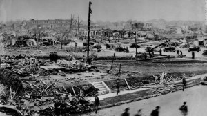
A view of the devastation in the Crosstown section west of downtown. The large building in the foreground has simply vanished.
Credit: The Commercial Appeal Collection
At 8:55pm, the tornado ripped through residential neighborhoods west and north of downtown. The effect was catastrophic. 48 city blocks were virtually obliterated. Entire subdivisions, including large brick homes, simply disintegrated. The Willis Heights neighborhood suffered the worst. Over 100 people died in that section alone. Whole families were wiped out. Fire swept the ruins following the tornado and the city’s water system was crippled, leaving firefighters helpless to stop the flames. Many survivors trapped in the ruins died in the blaze. In a miracle of mercy, however, a torrential rain fell not long after the tornado and eventually extinguished the flames. The city’s hospital was destroyed, so victims had to be taken to nearby towns. Many of them didn’t make it. In all, 1100 homes, ten churches and four schools were destroyed. Papers and other lightweight debris from Tupelo was found 140 miles away near Flintville, Tennessee.
The negro district was decimated. In those days, blacks were often kept out of official death tolls, so the true toll may never be known. The official death toll was 216. Modern research has since raised this to 233, but even that is probably conservative. Roughly 700 more were injured. A young Elvis Presley and his mother were among the survivors.
At 8:30am the next day, the height of morning rush hour, a monster F4 tore through the heart of Gainesville, Georgia. At least 243 people were killed. 70 died at the Copper Pants Factory alone. In just twelve hours, two tornadoes had killed at least 476 people and devastated two major cities. In the span of less than a week, 556 people died in tornadoes across the southeast. Outside of the incredible Tri-State Tornado in 1925, this was the worst week of tornadoes in US history. The only other event that even comes close was the final two weeks of May, 1896, when 484 people died. April, 1936’s monthly toll of 564 trails only the 748 from March, 1925.
Oshkosh, Nebraska – April 26, 1938
This tornado swept through open farm country across southern Garden County, Nebraska. It touched down about twelve miles southwest of Oshkosh and moved north-northeastward, steadily intensifying. It the “Lone Star” area about six miles northwest of Oshkosh, two farms were wiped out. At a nearby schoolhouse, a teacher and students were outside watching the ominous skies. Sadly, they never saw the mile-wide monster until it was too late. The teacher’s car and house as well as the schoolhouse were lifted into the air and dashed to pieces. Three students were killed, their bodies found a quarter of a mile away. They were the only casualties of the tornado, all of them under the age of 10. The tornado lifted about 15 miles to the north of Oshkosh near Crescent Lake National Wildlife Refuge.
Clyde, Texas – June 10, 1938
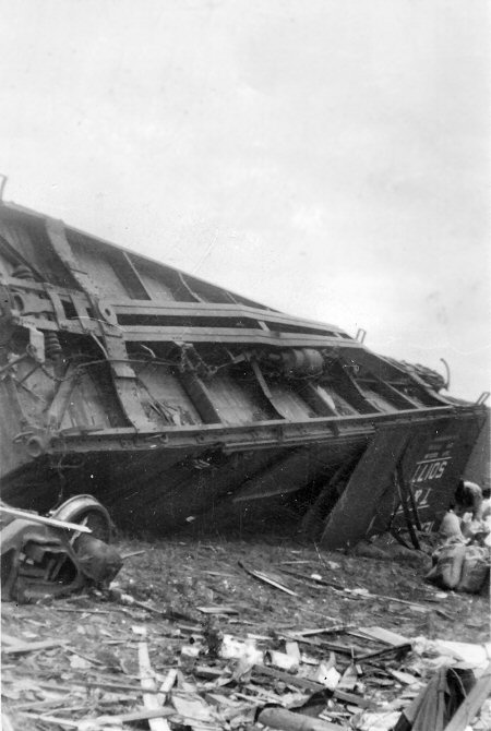
Large boxcars were thrown like toys.
Credit: Charles C. Chaney
This was a very slow moving tornado that ravaged the town of Clyde, Texas, twelve miles east-southeast of Abilene. Just 300 yards wide, the tornado swept down from the north, carving a ‘U’ shaped path through the west side of town, destroying at least 40 homes, some of which were entirely obliterated. All nine homes of a small subdivision vanished and bodies were thrown up to half a mile. A car trying to flee the tornado was caught when it suddenly changed direction and flung half a mile into a neighboring field. Miraculously, two children in the car survived. Four others died. The car itself was ripped to pieces. Only the engine and scattered debris was found. The tornado hit a freight train standing on the Texas and Western Railway. Nineteen cars were thrown from the tracks; at least two of which were hurled several yards, entirely clear of the right-of-way. One person on the train was killed. Fortunately, it was a very slow-moving storm and was visible for miles, giving those in its path time to seek shelter. As it was, 14 people were killed and another 40 were injured.
Capron, Oklahoma – April 14, 1939
This tornado devastated a large swath of rural northwest Oklahoma. It formed near Vici in extreme northwest Dewey County and moved northeast. Fifty homes on the southeast side of town were hit. Moving into Woodward County, the tornado passed very near the town of Mutual, steadily intensifying. By the time it crossed into Woods County south of Waynoka, it was roughly a mile wile. Entire farms between Waynoka and Alva were decimated. On farms near Hopeton, cars and other heavy farm machinery were hurled as much as half a mile through the air and large farmhouses were wiped from the face of the earth.

A view of the devastation along Broadway Street on the east side of Capron.
Credit: Wisconsin Rapids Daily Tribune
Curving more to the north-northeast, the tornado passed just east of Alva and then slammed into Capron. Half the town was destroyed, including the business district and a brick schoolhouse. A freight train pulled into Capron right as the tornado struck the town. Eight cars were thrown from the tracks and destroyed. Miraculously, despite the devastation and the fact that the tornado struck just after midnight without warning, no one in Capron seems to have died. This may have been due in part to the fact that the hardest hit section was mostly non-residential. A total of seven people did die in the tornado, most of them on farms south of Alva, and 33 were injured. The tornado would lift shortly after crossing the border into Kansas near the town of Kiowa.
Anoka, Minnesota – June 18, 1939
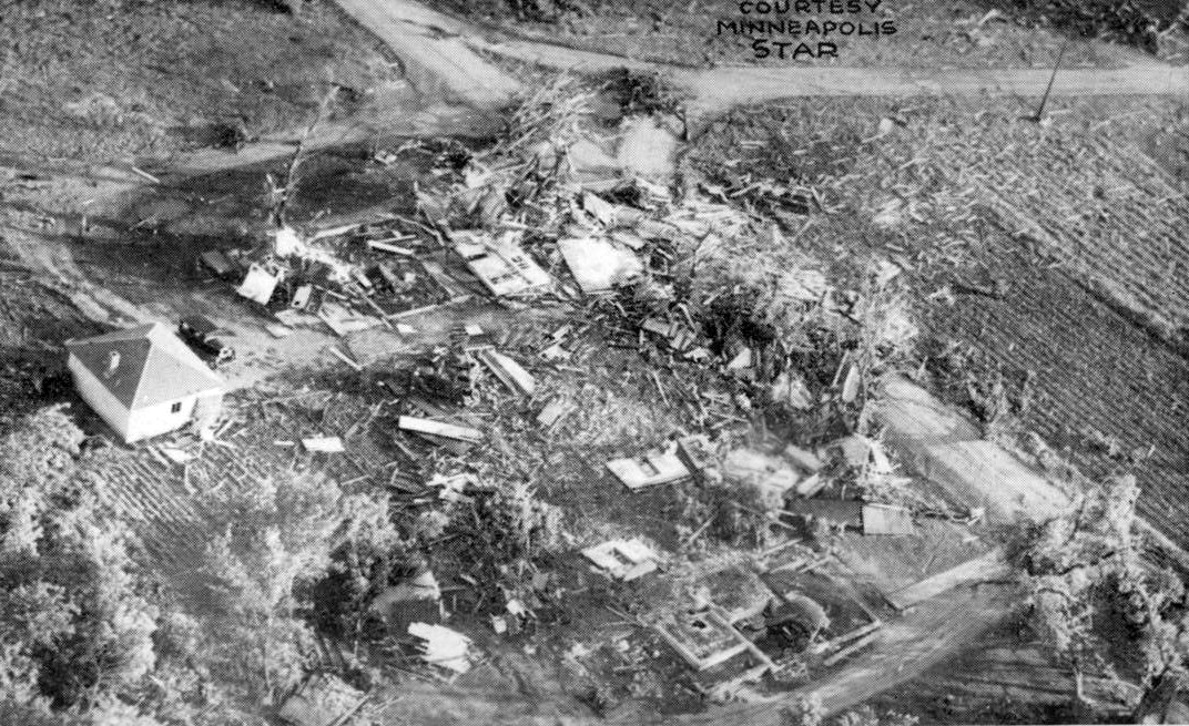
Obliterated homes in Anoka.
Credit: Minneapolis Star
This tornado ravaged the Anoka-Champlin area about 17 miles north of Minneapolis along the banks of the Mississippi River. It first touched down a few miles southwest of Corcoran and moved northeast, intensifying rapidly. Four homes near Corcoran were demolished and a car was thrown 300 yards through the air and smashed to pieces, killing the four people inside. The tornado then moved through the northern part of Maple Grove, somewhat weaker, before reintensifying as it neared Champlin. Tearing through Champlin as a large tornado, three blocks wide, one person was killed and numerous homes were destroyed.
As it crossed the river into Anoka, the tornado was so powerful that it actually sucked the river dry and stopped it from flowing until the tornado reached the other bank. Witnesses saw a half-mile wide column of water get drawn up into the funnel like a giant steam cloud. The tornado then devastated the residential section of Anoka, destroying some 250 homes. The armory, two churches, a Masonic temple and several business buildings were also destroyed. The tornado would go on to cause heavy damage in the town of Cedar before lifting well east of Bethel. At least nine people were killed and 222 were injured. Some researchers have questioned whether this tornado was truly an F5.
Lacon, Illinois – March 16, 1942
Taken near Spring Bay, looking northwest.
Credit: Donald Cox
Just three months after Pearl Harbor, this tornado devastated the quiet Illinois River town of Lacon, the seat of Marshall County. Part of a major early-season outbreak that saw devastating tornadoes also hit the towns of Water Valley, Mississippi; Bethel Springs, Tennessee; and Goshen, Indiana; the Lacon tornado touched down northwest of Peoria near Kickapoo and moved north-northeast, following the Illinois River. It first struck the northwest side of Chillicothe on the west bank, apparently with relatively minor damage. The tornado traveled along the west bank of the river for about two miles, passing just east of Hopewell. Two people were killed nearby. However, the tornado really intensified as it moved over the river northeast of Hopewell, churning up mud and water as it went.
The tornado roared through the residential section of Lacon as at least a strong F4 at about 4:30pm. That entire section of town was virtually obliterated. 60 homes, amounting to a quarter of the town, were completely destroyed, many of them all but vanished. A large, 14-room house was lifted into the air and dashed to pieces, the debris dropped into a neighboring yard. The fourteen people inside for a party were miraculously unhurt as they took shelter in the basement. A brand new $75,000 addition to the Lacon School was trashed. The upper floor was almost completely taken out. A nearby home was completely obliterated. Students finished the semester in makeshift classrooms in churches, the courthouse, and even a Ford garage. Several nearby farms were also devastated. One northeast of Lacon simply vanished, damage classified by researchers as F5. The tornado killed seven people and roughly 75 were injured.
Crowell, Texas – April 28, 1942
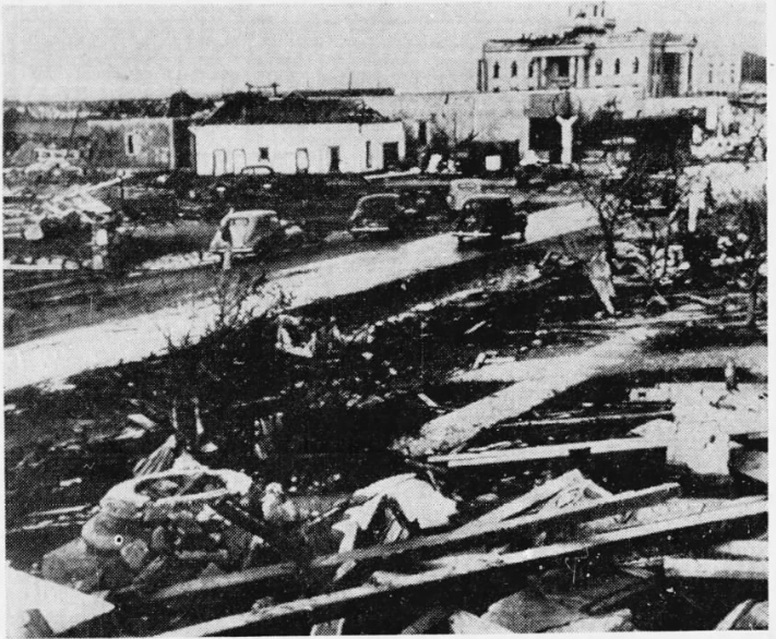
In the foreground is all that remained of the First Baptist Church, obliterated by the tornado. In the background is the wrecked courthouse. Its beautiful Greco-Roman architecture was never restored.
Credit: The Tampa Tribune
This monstrous tornado tore a path of destruction through the heart of Crowell, Texas; at the time a small city of about 2,000 people. It touched down not far to the northwest of the city and moved southeast, strengthening rapidly. The tornado slammed into the city at 9:30pm as a mile-wide F5. Crowell was devastated. Entire neighborhoods were wiped out. Survivors reported seeing cars and pieces of houses flying through the air.
The tornado struck the Foard County Courthouse, doing major damage to the masonry structure. The courthouse, built in 1910, had beautiful classical-style architecture. It had a cupola with clock faces on each side and a statue of Lady Justice atop its dome, as well as big, columned porticoes on each side. The tornado effectively destroyed the cupola, ripping out the clock mechanism, leaving only the east face intact, and knocked out most of the columns. The damage was so severe that when the courthouse was repaired, most of its distinctive classical features, including the cupola, were removed.
75% of Crowell, including the central business district, was leveled. Some homes simply vanished. A Baptist church was leveled and a large storage tank was thrown more than a block. Massive grapefruit sized hail followed the tornado, injuring several survivors who now had no shelter. Less than five months into World War II, building materials were scarce and the people of Crowell struggled to rebuild their town. The population never recovered. By the 2010 census, the population had dwindled to just 948. Eleven people were killed and some 250 were injured. All but 300 of the town’s 1900 residents were left homeless.
This tornado was part of another devastating outbreak that ravaged much of the Great Plains from April 27-May 2. It included a devastating F4 that wiped out a third of the town of Pryor, Oklahoma, killing 52, just the day before. It is the fifth deadliest tornado in Oklahoma history. The very next day, another powerful tornado ripped through Kansas.
Oberlin, Kansas – April 29, 1942
Just a day after the Crowell tornado, this narrow but powerful tornado ravaged Decatur County, Kansas. Touching down eight miles south of Oberlin, Kansas, the tornado devastated farms across southern Decatur County. The quarter-mile wide tornado headed due north along Route 83, directly toward Oberlin. The damage to farms south of town was appalling. The storm hit close to midnight, so most people were asleep. Three entire families were wiped out and entire farms were wiped from the face of the earth. Many buildings simply vanished. Not a vestige of them remained. The ruins of two farmhouses were reduced to bits no larger than matchsticks. It was impossible to tell that they had once been part of a house. In some places, several inches of topsoil was ripped out of the ground. Some of the victims were thrown a quarter of a mile. One of the bodies had their head and shoulders buried in the ground. The tornado passed just half a mile east of Oberlin, swerving just around the town and was accompanied by heavy rain and very large hail that caused widespread damage throughout Oberlin, however the town itself escaped major damage. The tornado lifted just east of the village of Cedar Bluffs near the Nebraska border.
There were so many victims that the small hospital in Oberlin was overwhelmed and some of the injured were taken to a nearby Methodist church. The fact that the tornado missed Oberlin, a fairly large country town of 1600 people, was somewhat miraculous. It traveled due north directly toward downtown but then swerved to the east and then back to the northwest. A straight line from the starting and ending points would go right through town. This fortunate twist of fate allowed relief to come quickly. As it was, 15 people died and 25 more were injured.
The outbreak continued, with a large F4 tornado hitting eastern Colorado of all places on April 30, demolishing four ranch homes over open country east of Eads. It was one of just two violent tornadoes that have struck Colorado since the 1920’s. The state hasn’t had a violent tornado since 1947. The outbreak ended with a series of violent, destructive tornadoes in Oklahoma on May 2, the worst of which killed twelve people when it obliterated the tiny farming village of Childsville, four miles north of Boley. Four others died on farms near Paden.

This farmhouse vanished south of Oberlin. Five people died here. Note the debarking of what were once large trees nearby.
Credit: The Decatur (IL) Herald
Wilmot, South Dakota – June 17, 1944
Overshadowed by the devastating outbreak that hit the mid-Atlantic states just a few days later, this powerful tornado touched down shortly after 5 pm on June 17, 1944 five miles south of Summit, South Dakota and moved northeast. The tornado intensified rapidly as it ripped through farmland south of Wilmot. Fifteen farms south and southwest of Wilmot were destroyed and some were completely swept away. A few farms vanished entirely, with the debris not even able to be located on the surrounding prairie. The tornado was up to a mile wide in this area. After passing east of Wilmot, it continued northeast at somewhat diminished intensity, crossing Big Stone Lake into Minnesota near Hiawatha Beach and lifting three miles east of Beardsley. Eight people were killed and many more were injured. The tornado was highly visible in Minnesota, though much narrower, with numerous rural residents watching the funnel snake across the countryside. Shortly after the funnel lifted, the parent thunderstorm collapsed, causing widespread severe wind damage in Big Stone County.
Just six days later, a series of devastating tornadoes ravaged the eastern US. The day before, on June 22, a violent F4 caused widespread major damage in Belmont, Wisconsin and surrounding farmland. Then on June 23, three more violent tornadoes struck Pennsylvania and West Virginia. One was a long-lived tornado family that killed 30 people across southwestern Pennsylvania, with the worst damage at the village of Chartiers, just south of Clarksville. Another ripped through the southern suburbs of Pittsburgh, leveling 88 homes in and around McKeesport. However the worst of them all was the mile-wide monster that obliterated the Appalachian hill country town of Shinnston, West Virginia, killing 100 people. It was the worst natural disaster in West Virginia history.
Antlers, Oklahoma – April 12, 1945
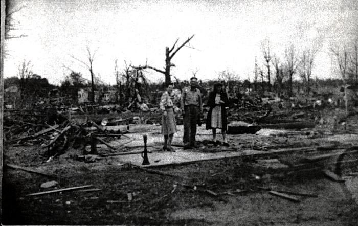
A home swept to its foundation in Antlers.
Credit: okgenweb
Normally a tornado as devastating as the one that struck Antlers, Oklahoma that day would be front page news. However at 3:35 pm that afternoon, as storm clouds were building over the Great Plains, President Franklin D. Roosevelt collapsed and died at his retreat in Warm Springs, Georgia. He had suffered a massive stroke. As the news exploded over radio stations across the country, the weather continued to go downhill in the Red River Valley of Oklahoma and Texas. Multiple violent tornadoes had already touched down in Oklahoma. One of them ripped through the southeastern suburbs of Oklahoma City, ravaging sections of Valley Brook and Del City. Hardest hit, however, was base housing at Tinker Air Force Base, where several family members of military personnel were killed. Another devastated the east side of Muskogee, where 13 people were killed at as school for the blind, most of them disabled children.
At about 5:30 pm, another tornado touched down several miles southwest of Antlers and moved northeast, intensifying rapidly. Ten minutes later, it plowed into the city of 3,200 without warning as a half-mile wide F5. The effect was devastating. At least a third of the town was destroyed. Nearly 400 homes and 200 other buildings were in ruins and some were completely swept away. The entire northeast section of town was gone. Only one home was left standing in a several block area. A three-story brick commercial building housing a bakery and several other businesses was leveled. At least four people died there. The injured and the dead were taken to nearby towns because local hospitals and morgues couldn’t handle them. The army set up a field kitchen in the ruined central business district. In all, 69 people were killed and 343 were injured.
Woodward, Oklahoma – April 9, 1947

The town of Glazier, Texas was completely wiped out by the tornado.
Credit: NOAA
Woodward, Oklahoma was a city of 5,426 people in 1947. The events of April 9 would make it legendary for all the wrong reasons. The storm, now believed to have been a series of tornadoes spawned by the same supercell, left a 220-mile path of destruction across three states. The first tornado struck near White Deer, Texas at 5:42 pm, causing widespread moderate damage. Another brief tornado hit farmland north of Pampa. The main tornado is believed to have touched down near Canadian a short time later and it quickly grew into a monster as it bore down on the tiny village of Glazier. It was a massive F5 as much as two miles wide, making it one of the largest tornadoes ever recorded. Glazier was wiped from the face of the earth. The entire town simply vanished. Just a single shell of a building remained standing. Most buildings were completely erased, their foundations swept clean. By some miracle, only 17 people died here in a town of 200. According to legend, two people who were together in Glazier were found three miles apart. Higgins, a town of roughly 750 just ten miles to the northeast down US 60, was next. It too was largely obliterated. An entire row of homes in downtown vanished. At one house, a four and a half ton steel lathe bolted to the floor was torn loose and broken in two. The ruins were swept by fire in the wake of the tornado, making rescue efforts difficult. 51 people died there.
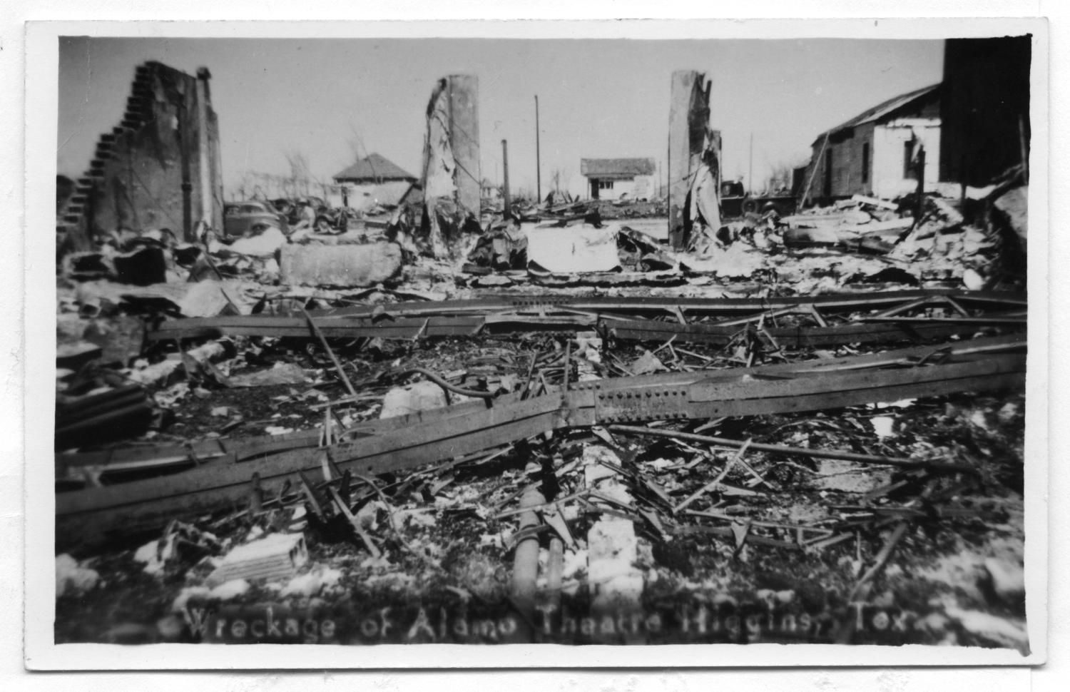
This was all that remained of the Alamo Theatre in Higgins, which was built of brick and reinforced with steel girders, which you see in the foreground.
Credit: University of North Texas
The tornado remained very powerful as it moved into the open farm country of western Oklahoma. Word of the devastation in Texas was slow to reach Oklahomans. Telephone wires were down across the affected region and the country was in the midst of a national telephone strike. In most places, only emergency operators were manning the switchboards. The tornado roared across open farmland, passing a few miles south of the towns of Shattuck and Gage, marching steadily northeastward. Numerous farms across Ellis County south of Highway 15 were wiped out, causing over $1 million in damage. Citizens in Gage reported hearing a roaring sound coming from the south. The telephone operator in Shattuck was the first to alert Woodward of the massive “black cloud” headed their way, but those in Woodward never really knew the true gravity of the situation until it was too late.
The still-massive tornado passed just a couple of miles from the town of Fargo, flattening farms and killing three people. Through all the destruction, few in Woodward had any idea of the horror that would soon visit them. For them, it was just a typical Wednesday night. Most residents had turned in for the evening. It was 8:42 pm when the tornado reached the outskirts of the city. It passed over Experimental Lake, sucking up a giant column of muddy water, giving the tornado an eerie red color. The water level in the lake dropped by a foot. The wind rose dramatically in Woodward as hail began to fall and a roaring could be heard in the sky, growing ever louder. Then…oblivion.
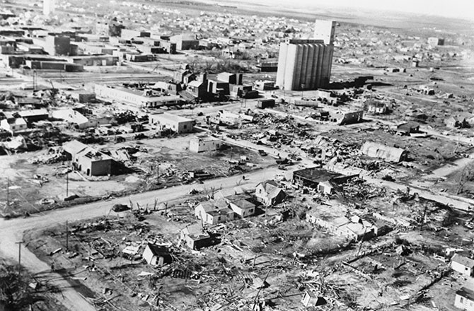
Downtown Woodward after the tornado.
Credit: Time Magazine
The two mile wide monster slammed into the northwest side of the city. Entire subdivisions were obliterated along with rows of businesses. One hundred city blocks were leveled, including large commercial buildings, some of them made of brick. The town’s industrial power plant took a direct hit and was largely destroyed. A 20-ton boiler was thrown a block and a half. Numerous cars and heavy machinery was thrown great distances. Not much effort was made to calculate these distances in the wake of the tornado but many were likely thrown hundreds of yards. The 8th Street Bridge across the North Canadian River was wiped out, the debris washed down river. The Woodward County Courthouse didn’t even take a direct hit from the tornado but still had some of its stone facade removed. Trees throughout the damage path in the city were shredded and debarked.
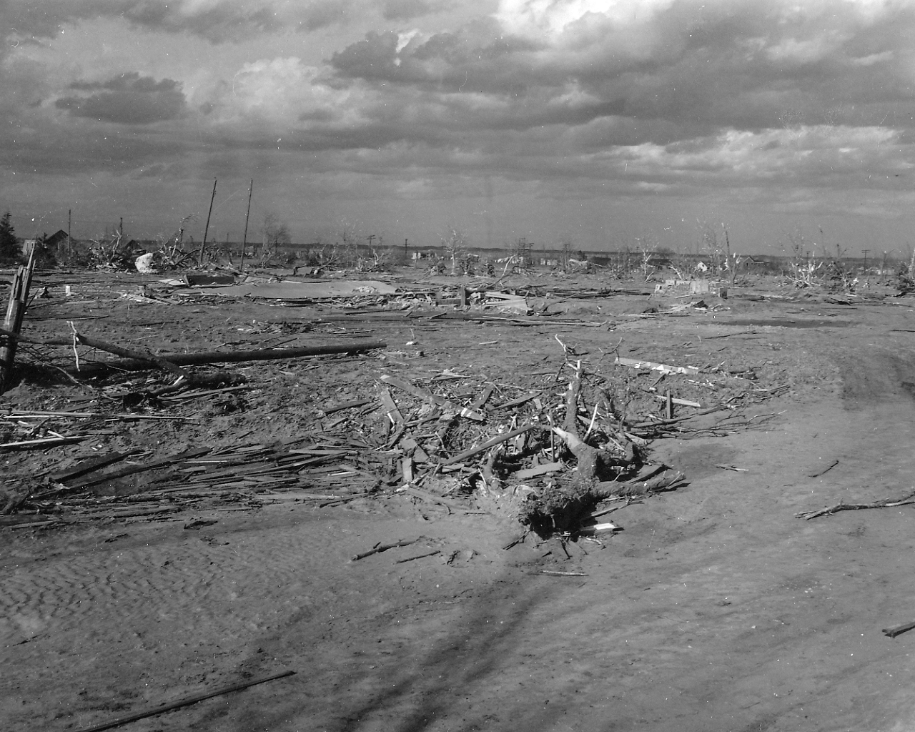
This large home in Woodward completely vanished, the debris carried well away from the site. The site of another vaporized home is visible on the far right of the picture. Several homes were swept away in this area.
Credit: NOAA
Downtown was in flames. Hundreds were trapped in collapsed buildings and hospitals were overwhelmed with the flood of wounded that came in. The streets were filled with rubble. The sky was lit up by vivid lightning. A torrential downpour followed the tornado and helped to put out the fires that had broken out across the ruined city. The temperature plummeted in the days following the tornado, with rescuers working through temperatures in the 30’s. On the 12th, a cold rain changed over to snow, and eventually a three inch blanket of snow covered the ruins. 107 people died in Woodward alone and half the city was destroyed.
Moving into Woods County, the tornado began to curve more to the NNE. It passed ten miles west of Alva, striking the now-extinct village of White Horse, destroying numerous homes. Thirty-six homes were destroyed across rural Woods County, mainly west of Alva, and thirty people were injured. The main tornado finally lifted shortly thereafter, however the supercell continued producing tornadoes. Crossing into Kansas, the cell dropped another tornado near the state line and moved NNE, passing west of Hardtner and into rural Barber County. The cell sporadically produced tornadoes as it passed west of Medicine Lodge and Nashville before finally petering out near the village of St. Leo.
In all, 181 people were killed, 970 were injured and nearly 2,000 buildings were destroyed. Total damage was conservatively estimated at nearly $9 million, $95.3 million in 2014, making it the costliest tornado event in history at the time. It was the worst natural disaster in the history of Oklahoma and the most devastating tornado ever recorded on the Great Plains. At least five distinct tornadoes are believed to have made up the Woodward tornado family, the longest of which being the most devastating section from Canadian, Texas to Woods County, Oklahoma, traveling over 100 miles across the Great Plains. It was one of the longest-track tornado events in history.
Leedey, Oklahoma – May 31, 1947
Less than two months after Woodward, western Oklahoma was hit again. This tornado formed over open farm country about five miles southeast of Crawford in Roger Mills County and moved east northeast, gradually strengthening. Leedey, Oklahoma was a small town of about 600 thirty miles south of Woodward. Naturally, their northern neighbors and the relief efforts going on there were still major news. Many Woodward residents were living in tents. Some had moved to relief shelters set up by the army, National Guard and relief organizations. It was also a time of heightened awareness and fear of tornadoes.
The day had a very ominous feel to it and news began coming in of a tornado that had hit some of the same areas hit by the Woodward tornado back in April, namely Higgins, Texas and Gage, Oklahoma. Arnett, Oklahoma was also hit. However the tragedy that hit Woodward earlier that spring was not repeated. It was a remarkably clear day and the half-mile wide tornado could be seen for miles across the open plains. A siren was sounded in Leedey and local police got on loudspeakers, urging people to seek shelter. Fortunately, most heeded the warning. The tornado slammed into the town just after dark on May 31, 1947. Half the town, including most of the business district, was completely destroyed. Many homes and businesses simply vanished, with very little debris left at the site. In some places, several inches of topsoil was pulled out of the ground. Some of the homes that vanished had their lawns scoured from the ground as well. Seven people were killed and fifteen people were injured. The advance warning is credited with saving many lives. The tornado lifted just three miles beyond Leedey near the Canadian River.
The outbreak continued into the next day, when a half-mile wide F4 devastated parts of Pine Bluff, Arkansas, killing 35 people. A week later, the last violent tornado to strike the state of Colorado to date ravaged farms southeast of Sterling.

The tornado moving over open country in western Oklahoma.
Credit: okgenweb
